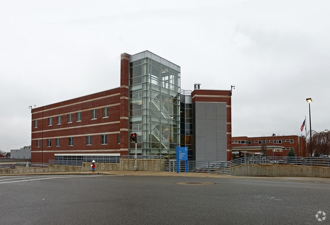
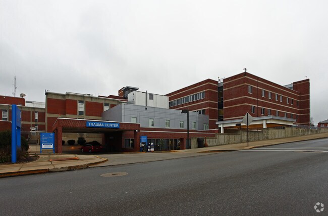
Property Record
325 Glessner Ave, Mansfield, OH 44903
Property Detail
325 Glessner Ave
027-01-500-06-000
OL 4 SD 1 + 20 FT VAC LIND AVE TO WEST
Hospitalprivate
RICHLAND
B and X Area of moderate flood hazard, usually the area between the limits of the 100-year and 500-year floods.
Ohio
0
6.83 AC
2025
Richland County
000500
Cleveland
492,672 SF
Mansfield, OH
NEARBY LISTINGS FOR SALE OR LEASE
-
-
View all Mansfield listings for sale on LoopNet.com
DEMOGRAPHICS near 325 Glessner Ave
1 mile
3 mile
5 mile
2025 Total Population
15,198
51,446
72,922
2030 Population
15,304
51,404
72,720
Pop Growth 2025-2030
+ 0.70%
(0.08%)
(0.28%)
Average Age
39
42
42
2025 Total Households
6,517
21,423
29,731
HH Growth 2025-2030
+ 0.63%
(0.16%)
(0.34%)
Median Household Inc
$40,282
$44,927
$50,221
Avg Household Size
2.20
2.10
2.20
2025 Avg HH Vehicles
1.00
2.00
2.00
Median Home Value
$104,796
$128,775
$149,917
Median Year Built
1948
1957
1961
Nearby Places
Map Layers
Map Styles
 Street
 Aerial
Layers
 Traffic
 Biking
Places
Listings with unknown addresses are not visible on the map
- Restaurants
- Banks
- Shops
- Fitness
- Groceries
Nearby Properties
Address
Land Use
TOTAL SIZE
Lot Size
Zoning
Address
Land Use
TOTAL SIZE
Lot Size
Zoning
456.50 AC
Address
Land Use
TOTAL SIZE
Lot Size
Zoning
354,710 SF
7.07 AC
Address
Land Use
TOTAL SIZE
Lot Size
Zoning
139,809 SF
0.99 AC
Address
Land Use
TOTAL SIZE
Lot Size
Zoning
0.06 AC
Address
Land Use
TOTAL SIZE
Lot Size
Zoning
148,135 SF
6.89 AC
Address
Land Use
TOTAL SIZE
Lot Size
Zoning
2.31 AC
Address
Land Use
TOTAL SIZE
Lot Size
Zoning
92,587 SF
48.78 AC
Address
Land Use
TOTAL SIZE
Lot Size
Zoning
52.67 AC
Address
Land Use
TOTAL SIZE
Lot Size
Zoning
15,490 SF
89.80 AC
Address
Land Use
TOTAL SIZE
Lot Size
Zoning
32,728 SF
56.23 AC
Address
Land Use
TOTAL SIZE
Lot Size
Zoning
48,602 SF
14.66 AC
Address
Land Use
TOTAL SIZE
Lot Size
Zoning
58,960 SF
2.30 AC
Address
Land Use
TOTAL SIZE
Lot Size
Zoning
66,940 SF
12.40 AC
Address
Land Use
TOTAL SIZE
Lot Size
Zoning
1.69 AC
Address
Land Use
TOTAL SIZE
Lot Size
Zoning
107,754 SF
3.38 AC
Address
Land Use
TOTAL SIZE
Lot Size
Zoning
76,069 SF
8 AC
Address
Land Use
TOTAL SIZE
Lot Size
Zoning
47.90 AC
Address
Land Use
TOTAL SIZE
Lot Size
Zoning
44,718 SF
0.47 AC
Address
Land Use
TOTAL SIZE
Lot Size
Zoning
63,442 SF
5.51 AC
Address
Land Use
TOTAL SIZE
Lot Size
Zoning
161,297 SF
8.12 AC
Address
Land Use
TOTAL SIZE
Lot Size
Zoning
106,361 SF
5.06 AC
Address
Land Use
TOTAL SIZE
Lot Size
Zoning
88,556 SF
12.32 AC
Address
Land Use
TOTAL SIZE
Lot Size
Zoning
2,948 SF
10.62 AC
Address
Land Use
TOTAL SIZE
Lot Size
Zoning
21,337 SF
11.30 AC
Address
Land Use
TOTAL SIZE
Lot Size
Zoning
82,695 SF
40.16 AC
Address
Land Use
TOTAL SIZE
Lot Size
Zoning
188,928 SF
18.94 AC
Address
Land Use
TOTAL SIZE
Lot Size
Zoning
16,578 SF
8.23 AC
Address
Land Use
TOTAL SIZE
Lot Size
Zoning
75,157 SF
0.41 AC
Address
Land Use
TOTAL SIZE
Lot Size
Zoning
31,064 SF
9 AC
The World's #1 Commercial Real Estate Marketplace
Connect with us
© 2026 CoStar Group
The information above has been obtained from sources believed reliable. While we do not doubt its accuracy we have not verified it and make no guarantee, warranty or representation about it. It is your responsibility to independently confirm its accuracy and completeness. Any projections, opinions, assumptions, or estimates used are for example only and do not represent the current or future performance of the property. The value of this transaction to you depends on tax and other factors which should be evaluated by your tax, financial, and legal advisors. You and your advisors should conduct a careful, independent investigation of the property to determine to your satisfaction the suitability of the property for your needs.