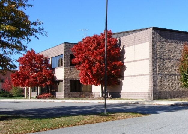
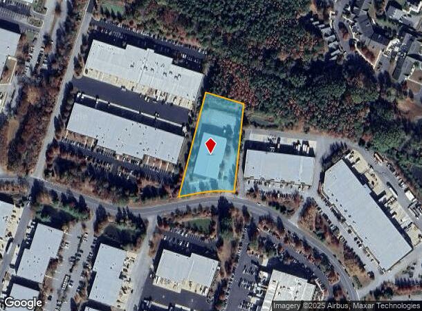
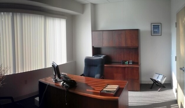
Property Record
325 Log Canoe Cir, Stevensville, MD 21666
NEARBY LISTINGS FOR SALE OR LEASE
Property Detail
325 Log Canoe Cir
04-095944
LOT 9-2.00 ACRES CHESAPEAKE BAY BUSINESS PARK - STEVENSVILLE
Warehouse
Queen Annes
X
Maryland
24035C0305D
9
2025
2 AC
2025
Queen Anne's County
810800
Baltimore
20,945 SF
Baltimore-Columbia-Towson, MD
DEMOGRAPHICS near 325 Log Canoe Cir
1 Mile
3 Mile
5 Mile
2024 Total Population
2,362
13,325
16,609
2029 Population
2,588
14,591
18,186
Pop Growth 2024-2029
+ 9.57%
+ 9.50%
+ 9.49%
Average Age
42
43
43
2024 Total Households
897
5,269
6,584
HH Growth 2024-2029
+ 9.59%
+ 9.38%
+ 9.36%
Median Household Inc
$112,356
$108,794
$108,099
Avg Household Size
2.60
2.50
2.50
2024 Avg HH Vehicles
2.00
2.00
2.00
Median Home Value
$406,203
$413,101
$421,235
Median Year Built
1994
1993
1992
Nearby Places
Map Layers
Map Styles
 Street
 Aerial
- Restaurants
- Banks
- Shops
- Fitness
- Groceries
PUBLIC TRANSPORTATION
AIRPORT
Baltimore/Washington International Thurgood Marshall
DRIVE
WALK
Distance
Baltimore/Washington International Thurgood Marshall
49 min
30.8 mi
Freight Ports
Port of Baltimore
DRIVE
WALK
Distance
Port of Baltimore
55 min
32.6 mi
Nearby Properties
Address
Land Use
TOTAL SIZE
Lot Size
Zoning
Address
Land Use
TOTAL SIZE
Lot Size
Zoning
2,736 SF
40.07 AC
NC-2
Address
Land Use
TOTAL SIZE
Lot Size
Zoning
189,500 SF
45.83 AC
SE
Address
Land Use
TOTAL SIZE
Lot Size
Zoning
47,432 SF
35.88 AC
SIBE
Address
Land Use
TOTAL SIZE
Lot Size
Zoning
706 SF
7.66 AC
APKIG
Address
Land Use
TOTAL SIZE
Lot Size
Zoning
74,465 SF
15.34 AC
SE
Address
Land Use
TOTAL SIZE
Lot Size
Zoning
53,028 SF
3.99 AC
Address
Land Use
TOTAL SIZE
Lot Size
Zoning
93,468 SF
9.53 AC
VC
Address
Land Use
TOTAL SIZE
Lot Size
Zoning
5,990 SF
269.80 AC
NC-8
Address
Land Use
TOTAL SIZE
Lot Size
Zoning
69,300 SF
13.95 AC
SIBE
Address
Land Use
TOTAL SIZE
Lot Size
Zoning
6,597 SF
19.53 AC
SE
Address
Land Use
TOTAL SIZE
Lot Size
Zoning
64,556 SF
3.10 AC
UC
Address
Land Use
TOTAL SIZE
Lot Size
Zoning
45,151 SF
5.97 AC
TC
Address
Land Use
TOTAL SIZE
Lot Size
Zoning
145,524 SF
17 AC
SIBE
Address
Land Use
TOTAL SIZE
Lot Size
Zoning
95,510 SF
18.77 AC
UC
Address
Land Use
TOTAL SIZE
Lot Size
Zoning
1,484 SF
3.08 AC
TC
Address
Land Use
TOTAL SIZE
Lot Size
Zoning
33,214 SF
16 AC
SE
Address
Land Use
TOTAL SIZE
Lot Size
Zoning
1,024 SF
67.55 AC
APKIG
Address
Land Use
TOTAL SIZE
Lot Size
Zoning
5,678 SF
2.20 AC
UC
Address
Land Use
TOTAL SIZE
Lot Size
Zoning
113,414 SF
8.40 AC
SIBE
Address
Land Use
TOTAL SIZE
Lot Size
Zoning
16,200 SF
0.62 AC
SIBE
Address
Land Use
TOTAL SIZE
Lot Size
Zoning
16,130 SF
4.78 AC
UC
Address
Land Use
TOTAL SIZE
Lot Size
Zoning
8,976 SF
225.79 AC
CS
Address
Land Use
TOTAL SIZE
Lot Size
Zoning
6,000 SF
7.37 AC
CMPD
Address
Land Use
TOTAL SIZE
Lot Size
Zoning
8,268 SF
4.01 AC
UC
Address
Land Use
TOTAL SIZE
Lot Size
Zoning
9,470 SF
15.93 AC
SE
Address
Land Use
TOTAL SIZE
Lot Size
Zoning
8,268 SF
20.64 AC
UC
Address
Land Use
TOTAL SIZE
Lot Size
Zoning
12,036 SF
1.54 AC
TC
Address
Land Use
TOTAL SIZE
Lot Size
Zoning
14,473 SF
1.73 AC
TC
Address
Land Use
TOTAL SIZE
Lot Size
Zoning
37,202 SF
3.23 AC
TC
Address
Land Use
TOTAL SIZE
Lot Size
Zoning
8,040 SF
33.35 AC
SE
The World's #1 Commercial Real Estate Marketplace
Connect with us
© 2025 CoStar Group
The information above has been obtained from sources believed reliable. While we do not doubt its accuracy we have not verified it and make no guarantee, warranty or representation about it. It is your responsibility to independently confirm its accuracy and completeness. Any projections, opinions, assumptions, or estimates used are for example only and do not represent the current or future performance of the property. The value of this transaction to you depends on tax and other factors which should be evaluated by your tax, financial, and legal advisors. You and your advisors should conduct a careful, independent investigation of the property to determine to your satisfaction the suitability of the property for your needs.