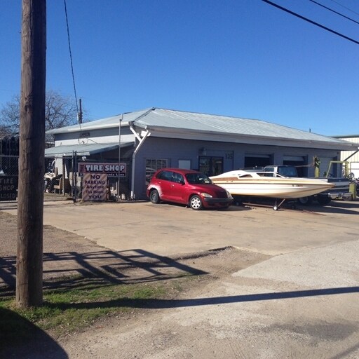
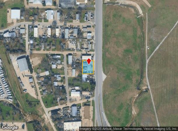
Property Record
325 N Grants Ln, Fort Worth, TX 76108
NEARBY LISTINGS FOR SALE OR LEASE
Property Detail
325 N Grants Ln
Dallas-Fort Worth-Arlington, TX
Brookdale Addition
00300306
BROOKDALE ADDITION BLOCK 3 LOT 6 THRU 8
Commercialnec
Tarrant
AE
Texas
48439C0165K
6-8
2024
0.43 AC
2025
West Fort Worth
110706
Dallas/Ft Worth
3,304 SF
DEMOGRAPHICS near 325 N Grants Ln
1 Mile
3 Mile
5 Mile
2024 Total Population
4,877
74,178
196,582
2029 Population
5,255
78,596
208,374
Pop Growth 2024-2029
+ 7.75%
+ 5.96%
+ 6.00%
Average Age
37
37
37
2024 Total Households
1,709
29,695
78,788
HH Growth 2024-2029
+ 8.02%
+ 6.17%
+ 6.20%
Median Household Inc
$49,448
$48,536
$58,804
Avg Household Size
2.70
2.40
2.40
2024 Avg HH Vehicles
3.00
2.00
2.00
Median Home Value
$166,884
$231,292
$246,087
Median Year Built
1964
1977
1978
Nearby Places
Map Layers
Map Styles
 Street
 Aerial
- Restaurants
- Banks
- Shops
- Fitness
- Groceries
PUBLIC TRANSPORTATION
COMMUTER RAIL
Texas And Pacific (T&P) (Trinity Railway Express - Dallas Area Rapid Transit (DART))
DRIVE
WALK
Distance
Texas And Pacific (T&P) (Trinity Railway Express - Dallas Area Rapid Transit (DART))
16 min
9.2 mi
Fort Worth (Heartland Flyer - Amtrak, Texas Eagle - Amtrak)
DRIVE
WALK
Distance
Fort Worth (Heartland Flyer - Amtrak, Texas Eagle - Amtrak)
16 min
9.6 mi
AIRPORT
Dallas-Fort Worth International
DRIVE
WALK
Distance
Dallas-Fort Worth International
45 min
35.1 mi
Freight Ports
Port of Shreveport
DRIVE
WALK
Distance
Port of Shreveport
259 min
238.9 mi
SALE & LEASE HISTORY
LISTING DATE
SALE/LEASE

Jun 20, 2018
For Sale
Nearby Properties
Address
Land Use
TOTAL SIZE
Lot Size
Zoning
Address
Land Use
TOTAL SIZE
Lot Size
Zoning
469,191 SF
4.20 AC
Address
Land Use
TOTAL SIZE
Lot Size
Zoning
378,038 SF
7.01 AC
Address
Land Use
TOTAL SIZE
Lot Size
Zoning
401,487 SF
6.16 AC
Address
Land Use
TOTAL SIZE
Lot Size
Zoning
314,284 SF
26.29 AC
Address
Land Use
TOTAL SIZE
Lot Size
Zoning
242,244 SF
27.01 AC
Address
Land Use
TOTAL SIZE
Lot Size
Zoning
531,597 SF
31.71 AC
Address
Land Use
TOTAL SIZE
Lot Size
Zoning
424,333 SF
12.59 AC
Address
Land Use
TOTAL SIZE
Lot Size
Zoning
315,552 SF
14.84 AC
Address
Land Use
TOTAL SIZE
Lot Size
Zoning
352,999 SF
12.63 AC
Address
Land Use
TOTAL SIZE
Lot Size
Zoning
233,269 SF
8.81 AC
Address
Land Use
TOTAL SIZE
Lot Size
Zoning
357,676 SF
9.03 AC
Address
Land Use
TOTAL SIZE
Lot Size
Zoning
203,357 SF
11.13 AC
Address
Land Use
TOTAL SIZE
Lot Size
Zoning
293,358 SF
6.95 AC
Address
Land Use
TOTAL SIZE
Lot Size
Zoning
136,717 SF
12.07 AC
Address
Land Use
TOTAL SIZE
Lot Size
Zoning
284,418 SF
15.86 AC
Address
Land Use
TOTAL SIZE
Lot Size
Zoning
238,580 SF
11.56 AC
Address
Land Use
TOTAL SIZE
Lot Size
Zoning
245,043 SF
13.10 AC
Address
Land Use
TOTAL SIZE
Lot Size
Zoning
118,265 SF
6.63 AC
Address
Land Use
TOTAL SIZE
Lot Size
Zoning
321,124 SF
13.20 AC
Address
Land Use
TOTAL SIZE
Lot Size
Zoning
167,884 SF
10.90 AC
Address
Land Use
TOTAL SIZE
Lot Size
Zoning
203,179 SF
11.57 AC
Address
Land Use
TOTAL SIZE
Lot Size
Zoning
230,766 SF
9.24 AC
Address
Land Use
TOTAL SIZE
Lot Size
Zoning
177,726 SF
8.15 AC
Address
Land Use
TOTAL SIZE
Lot Size
Zoning
125,493 SF
16.55 AC
Address
Land Use
TOTAL SIZE
Lot Size
Zoning
104,831 SF
13.50 AC
Address
Land Use
TOTAL SIZE
Lot Size
Zoning
103,270 SF
13.01 AC
Address
Land Use
TOTAL SIZE
Lot Size
Zoning
264,125 SF
16.25 AC
Address
Land Use
TOTAL SIZE
Lot Size
Zoning
237,447 SF
12.95 AC
Address
Land Use
TOTAL SIZE
Lot Size
Zoning
161,746 SF
9.43 AC
Address
Land Use
TOTAL SIZE
Lot Size
Zoning
236,934 SF
51.75 AC
The World's #1 Commercial Real Estate Marketplace
Connect with us
© 2025 CoStar Group
The information above has been obtained from sources believed reliable. While we do not doubt its accuracy we have not verified it and make no guarantee, warranty or representation about it. It is your responsibility to independently confirm its accuracy and completeness. Any projections, opinions, assumptions, or estimates used are for example only and do not represent the current or future performance of the property. The value of this transaction to you depends on tax and other factors which should be evaluated by your tax, financial, and legal advisors. You and your advisors should conduct a careful, independent investigation of the property to determine to your satisfaction the suitability of the property for your needs.