Property Record
325 S Highway 62 Rd, Avoca, AR 72711
NEARBY LISTINGS FOR SALE OR LEASE
Property Detail
325 S Highway 62 Rd
04-00027-000
Avoca
Apartment
A PART OF THE SW1/4 OF THE SW1/4 OF SECTION 16, TOWNSHIP 20 NORTH, RANGE 29 WEST IN BENTON COUNTY, ARKANSAS, BEING MORE PARTICULARLY DESCRIBED AS FOLLOWS: TRACT 1 COMMENCING AT THE NW CORNER OF THE SW1/4 OF THE SW1/4 BEING A FOUND 5/8 IRON REBAR; THE
X
Benton
05007C0115K
Arkansas
2025
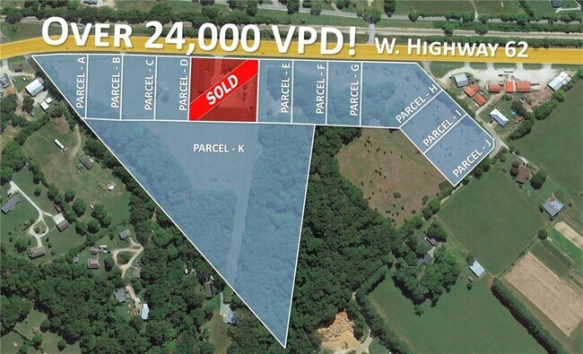
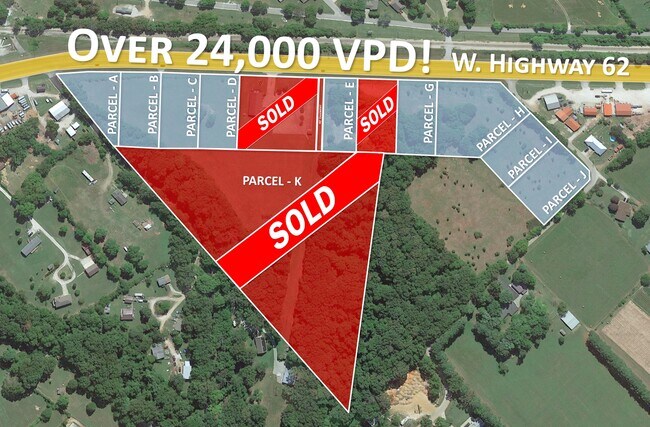
10.56 AC
2025
East Rogers
021404
Fayetteville/Springdale/Rogers
4,900 SF
Fayetteville-Springdale-Rogers, AR-MO
DEMOGRAPHICS near 325 S Highway 62 Rd
1 Mile
3 Mile
5 Mile
2024 Total Population
785
7,444
32,373
2029 Population
929
8,776
38,067
Pop Growth 2024-2029
+ 18.34%
+ 17.89%
+ 17.59%
Average Age
40
40
39
2024 Total Households
275
2,543
11,593
HH Growth 2024-2029
+ 18.18%
+ 18.01%
+ 17.61%
Median Household Inc
$83,881
$77,646
$72,149
Avg Household Size
2.80
2.80
2.70
2024 Avg HH Vehicles
2.00
2.00
2.00
Median Home Value
$259,740
$258,079
$244,666
Median Year Built
1994
1993
1992
Nearby Places
Map Layers
Map Styles
 Street
 Aerial
- Restaurants
- Banks
- Shops
- Fitness
- Groceries
PUBLIC TRANSPORTATION
AIRPORT
Northwest Arkansas Ntl
DRIVE
WALK
Distance
Northwest Arkansas Ntl
38 min
20.4 mi
Freight Ports
Tulsa Port of Inola
DRIVE
WALK
Distance
Tulsa Port of Inola
125 min
105.7 mi
SALE & LEASE HISTORY
LISTING DATE
SALE/LEASE

Apr 22, 2022
For Sale
Nearby Properties
Address
Land Use
TOTAL SIZE
Lot Size
Zoning
Address
Land Use
TOTAL SIZE
Lot Size
Zoning
109,683 SF
Address
Land Use
TOTAL SIZE
Lot Size
Zoning
67,745 SF
4.61 AC
Address
Land Use
TOTAL SIZE
Lot Size
Zoning
61,024 SF
4.19 AC
Address
Land Use
TOTAL SIZE
Lot Size
Zoning
58,990 SF
5.70 AC
Address
Land Use
TOTAL SIZE
Lot Size
Zoning
2,027 SF
1.07 AC
Address
Land Use
TOTAL SIZE
Lot Size
Zoning
9,541 SF
9.86 AC
Address
Land Use
TOTAL SIZE
Lot Size
Zoning
16,800 SF
6.10 AC
Address
Land Use
TOTAL SIZE
Lot Size
Zoning
23,814 SF
4.08 AC
Address
Land Use
TOTAL SIZE
Lot Size
Zoning
120.12 AC
Address
Land Use
TOTAL SIZE
Lot Size
Zoning
39,805 SF
6.77 AC
Address
Land Use
TOTAL SIZE
Lot Size
Zoning
39,905 SF
11.04 AC
Address
Land Use
TOTAL SIZE
Lot Size
Zoning
8,491 SF
19.82 AC
Address
Land Use
TOTAL SIZE
Lot Size
Zoning
100 AC
Address
Land Use
TOTAL SIZE
Lot Size
Zoning
40,000 SF
4.90 AC
Address
Land Use
TOTAL SIZE
Lot Size
Zoning
32,400 SF
7 AC
Address
Land Use
TOTAL SIZE
Lot Size
Zoning
7,520 SF
4.80 AC
Address
Land Use
TOTAL SIZE
Lot Size
Zoning
35,000 SF
1.91 AC
Address
Land Use
TOTAL SIZE
Lot Size
Zoning
16,224 SF
5.71 AC
Address
Land Use
TOTAL SIZE
Lot Size
Zoning
57.90 AC
Address
Land Use
TOTAL SIZE
Lot Size
Zoning
17,666 SF
3.08 AC
Address
Land Use
TOTAL SIZE
Lot Size
Zoning
9,301 SF
1.13 AC
Address
Land Use
TOTAL SIZE
Lot Size
Zoning
11,409 SF
4.09 AC
Address
Land Use
TOTAL SIZE
Lot Size
Zoning
13,724 SF
2.05 AC
Address
Land Use
TOTAL SIZE
Lot Size
Zoning
16,905 SF
Address
Land Use
TOTAL SIZE
Lot Size
Zoning
15,644 SF
2.34 AC
Address
Land Use
TOTAL SIZE
Lot Size
Zoning
2,490 SF
2.30 AC
Address
Land Use
TOTAL SIZE
Lot Size
Zoning
10,000 SF
Address
Land Use
TOTAL SIZE
Lot Size
Zoning
6,440 SF
3.15 AC
Address
Land Use
TOTAL SIZE
Lot Size
Zoning
8,820 SF
14.31 AC
The World's #1 Commercial Real Estate Marketplace
Connect with us
© 2026 CoStar Group
The information above has been obtained from sources believed reliable. While we do not doubt its accuracy we have not verified it and make no guarantee, warranty or representation about it. It is your responsibility to independently confirm its accuracy and completeness. Any projections, opinions, assumptions, or estimates used are for example only and do not represent the current or future performance of the property. The value of this transaction to you depends on tax and other factors which should be evaluated by your tax, financial, and legal advisors. You and your advisors should conduct a careful, independent investigation of the property to determine to your satisfaction the suitability of the property for your needs.