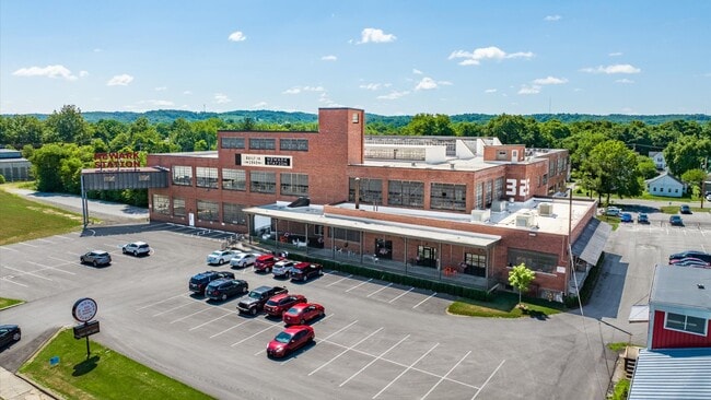
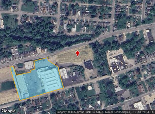
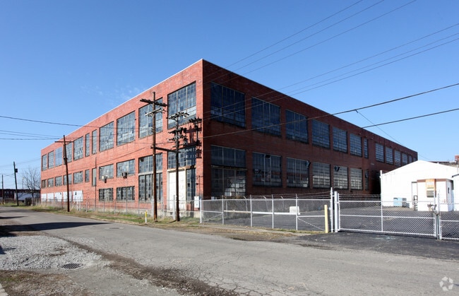
Property Record
325 W Main St, Newark, OH 43055
NEARBY LISTINGS FOR SALE OR LEASE
Property Detail
325 W Main St
054-217764-00.000
Jerome Buckingham
Retailwithmorethanonenonretailuse
4.233 AC R12 T2 Q4 TAX ABATE CRA 2024-2035
AE
Licking
39089C0341H
Ohio
2024
4.23 AC
2024
Licking County
750700
Columbus
104,064 SF
Columbus, OH
DEMOGRAPHICS near 325 W Main St
1 Mile
3 Mile
5 Mile
2024 Total Population
12,189
54,953
73,837
2029 Population
12,827
57,498
77,336
Pop Growth 2024-2029
+ 5.23%
+ 4.63%
+ 4.74%
Average Age
38
40
41
2024 Total Households
5,042
23,101
30,180
HH Growth 2024-2029
+ 5.18%
+ 4.64%
+ 4.76%
Median Household Inc
$42,824
$54,277
$59,124
Avg Household Size
2.30
2.30
2.30
2024 Avg HH Vehicles
2.00
2.00
2.00
Median Home Value
$88,989
$145,535
$160,749
Median Year Built
1948
1962
1968
Nearby Places
Map Layers
Map Styles
 Street
 Aerial
- Restaurants
- Banks
- Shops
- Fitness
- Groceries
PUBLIC TRANSPORTATION
AIRPORT
John Glenn Columbus International
DRIVE
WALK
Distance
John Glenn Columbus International
43 min
32.3 mi
Freight Ports
Port of Toledo
DRIVE
WALK
Distance
Port of Toledo
197 min
161.0 mi
SALE & LEASE HISTORY
LISTING DATE
SALE/LEASE

Sep 24, 2016
For Lease
Nearby Properties
Address
Land Use
TOTAL SIZE
Lot Size
Zoning
Address
Land Use
TOTAL SIZE
Lot Size
Zoning
8,024,080 SF
20 AC
Address
Land Use
TOTAL SIZE
Lot Size
Zoning
212,744 SF
19.16 AC
Address
Land Use
TOTAL SIZE
Lot Size
Zoning
54,600 SF
101.38 AC
Address
Land Use
TOTAL SIZE
Lot Size
Zoning
87,785 SF
37.26 AC
Address
Land Use
TOTAL SIZE
Lot Size
Zoning
68,326 SF
28.51 AC
Address
Land Use
TOTAL SIZE
Lot Size
Zoning
69,244 SF
38 AC
Address
Land Use
TOTAL SIZE
Lot Size
Zoning
1,537,139 SF
11.11 AC
Address
Land Use
TOTAL SIZE
Lot Size
Zoning
67,824 SF
16.26 AC
Address
Land Use
TOTAL SIZE
Lot Size
Zoning
143,636 SF
7.25 AC
Address
Land Use
TOTAL SIZE
Lot Size
Zoning
3,108 SF
19.22 AC
Address
Land Use
TOTAL SIZE
Lot Size
Zoning
69,782 SF
2.41 AC
Address
Land Use
TOTAL SIZE
Lot Size
Zoning
206,532 SF
21.65 AC
Address
Land Use
TOTAL SIZE
Lot Size
Zoning
223,436 SF
19.22 AC
Address
Land Use
TOTAL SIZE
Lot Size
Zoning
118,791 SF
16.01 AC
Address
Land Use
TOTAL SIZE
Lot Size
Zoning
4,018,110 SF
19.93 AC
Address
Land Use
TOTAL SIZE
Lot Size
Zoning
19,200 SF
14.56 AC
Address
Land Use
TOTAL SIZE
Lot Size
Zoning
73,269 SF
15.64 AC
Address
Land Use
TOTAL SIZE
Lot Size
Zoning
3,552 SF
5.23 AC
Address
Land Use
TOTAL SIZE
Lot Size
Zoning
31,271 SF
20.10 AC
Address
Land Use
TOTAL SIZE
Lot Size
Zoning
94,672 SF
13.37 AC
Address
Land Use
TOTAL SIZE
Lot Size
Zoning
4,080 SF
12.84 AC
Address
Land Use
TOTAL SIZE
Lot Size
Zoning
57,280 SF
4.04 AC
Address
Land Use
TOTAL SIZE
Lot Size
Zoning
50,482 SF
13.91 AC
Address
Land Use
TOTAL SIZE
Lot Size
Zoning
33,492 SF
1.07 AC
Address
Land Use
TOTAL SIZE
Lot Size
Zoning
22,974 SF
1.64 AC
Address
Land Use
TOTAL SIZE
Lot Size
Zoning
79,454 SF
19.13 AC
Address
Land Use
TOTAL SIZE
Lot Size
Zoning
78,000 SF
25 AC
Address
Land Use
TOTAL SIZE
Lot Size
Zoning
63,635 SF
7.91 AC
Address
Land Use
TOTAL SIZE
Lot Size
Zoning
135,148 SF
14.94 AC
Address
Land Use
TOTAL SIZE
Lot Size
Zoning
65,860 SF
3.35 AC
The World's #1 Commercial Real Estate Marketplace
Connect with us
© 2025 CoStar Group
The information above has been obtained from sources believed reliable. While we do not doubt its accuracy we have not verified it and make no guarantee, warranty or representation about it. It is your responsibility to independently confirm its accuracy and completeness. Any projections, opinions, assumptions, or estimates used are for example only and do not represent the current or future performance of the property. The value of this transaction to you depends on tax and other factors which should be evaluated by your tax, financial, and legal advisors. You and your advisors should conduct a careful, independent investigation of the property to determine to your satisfaction the suitability of the property for your needs.