Property Record
325 W Wegner Rd, Mchenry, IL 60051
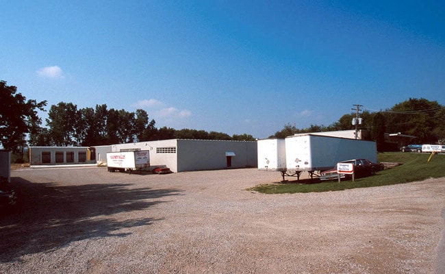

Property Detail
325 W Wegner Rd
15-05-400-007
W320 FT N396.12
Industrialgeneral
McHenry
A Areas with a 1% annual chance of flooding and a 26% chance of flooding over the life of a 30-year mortgage.
Illinois
2024
2.91 AC
2024
McHenry County
870811
Chicago
54,300 SF
Chicago-Naperville-Elgin, IL-IN
NEARBY LISTINGS FOR SALE OR LEASE
DEMOGRAPHICS near 325 W Wegner Rd
1 mile
3 mile
5 mile
2025 Total Population
2,870
22,214
80,709
2030 Population
2,915
22,597
82,043
Pop Growth 2025-2030
+ 1.57%
+ 1.72%
+ 1.65%
Average Age
41
40
41
2025 Total Households
1,094
8,511
31,006
HH Growth 2025-2030
+ 1.55%
+ 1.75%
+ 1.70%
Median Household Inc
$104,379
$105,632
$101,246
Avg Household Size
2.60
2.60
2.60
2025 Avg HH Vehicles
2.00
2.00
2.00
Median Home Value
$298,304
$278,888
$284,505
Median Year Built
1990
1992
1991
Nearby Places
Map Layers
Map Styles
 Street
 Aerial
Layers
 Traffic
 Biking
Places
Listings with unknown addresses are not visible on the map
- Restaurants
- Banks
- Shops
- Fitness
- Groceries
PUBLIC TRANSPORTATION
COMMUTER RAIL
McHenry Station (Union Pacific Northwest Line - Northeast Illinois Regional Commuter Railroad (Metra))
Drive
Walk
Distance
McHenry Station (Union Pacific Northwest Line - Northeast Illinois Regional Commuter Railroad (Metra))
11 min
5.2 mi
Round Lake Station (Milwaukee District North Line - Northeast Illinois Regional Commuter Railroad (Metra))
Drive
Walk
Distance
Round Lake Station (Milwaukee District North Line - Northeast Illinois Regional Commuter Railroad (Metra))
13 min
7.3 mi
AIRPORT
Chicago O'Hare International
Drive
Walk
Distance
Chicago O'Hare International
73 min
39.5 mi
Freight Ports
Port Milwaukee
Drive
Walk
Distance
Port Milwaukee
81 min
62.5 mi
Nearby Properties
Address
Land Use
TOTAL SIZE
Lot Size
Zoning
Address
Land Use
TOTAL SIZE
Lot Size
Zoning
12.28 AC
Address
Land Use
TOTAL SIZE
Lot Size
Zoning
4,529,441 SF
32.23 AC
Address
Land Use
TOTAL SIZE
Lot Size
Zoning
Address
Land Use
TOTAL SIZE
Lot Size
Zoning
163,715 SF
35.43 AC
Address
Land Use
TOTAL SIZE
Lot Size
Zoning
241,227 SF
15.79 AC
Address
Land Use
TOTAL SIZE
Lot Size
Zoning
19,224 SF
7 AC
Address
Land Use
TOTAL SIZE
Lot Size
Zoning
212,880 SF
20.06 AC
Address
Land Use
TOTAL SIZE
Lot Size
Zoning
12.56 AC
Address
Land Use
TOTAL SIZE
Lot Size
Zoning
18.82 AC
Address
Land Use
TOTAL SIZE
Lot Size
Zoning
20.47 AC
Address
Land Use
TOTAL SIZE
Lot Size
Zoning
448,000 SF
8.28 AC
Address
Land Use
TOTAL SIZE
Lot Size
Zoning
1,525,750 SF
7.55 AC
Address
Land Use
TOTAL SIZE
Lot Size
Zoning
302,400 SF
7.37 AC
Address
Land Use
TOTAL SIZE
Lot Size
Zoning
81,478 SF
9.25 AC
Address
Land Use
TOTAL SIZE
Lot Size
Zoning
Address
Land Use
TOTAL SIZE
Lot Size
Zoning
26,896 SF
4.03 AC
Address
Land Use
TOTAL SIZE
Lot Size
Zoning
20,403 SF
6.47 AC
Address
Land Use
TOTAL SIZE
Lot Size
Zoning
2.28 AC
Address
Land Use
TOTAL SIZE
Lot Size
Zoning
23,640 SF
1.26 AC
Address
Land Use
TOTAL SIZE
Lot Size
Zoning
19,500 SF
0.78 AC
Address
Land Use
TOTAL SIZE
Lot Size
Zoning
4.19 AC
Address
Land Use
TOTAL SIZE
Lot Size
Zoning
163,800 SF
5 AC
Address
Land Use
TOTAL SIZE
Lot Size
Zoning
5,398 SF
38 AC
Address
Land Use
TOTAL SIZE
Lot Size
Zoning
76,740 SF
12.03 AC
Address
Land Use
TOTAL SIZE
Lot Size
Zoning
87,600 SF
17.05 AC
Address
Land Use
TOTAL SIZE
Lot Size
Zoning
Address
Land Use
TOTAL SIZE
Lot Size
Zoning
17,939 SF
16.60 AC
Address
Land Use
TOTAL SIZE
Lot Size
Zoning
Address
Land Use
TOTAL SIZE
Lot Size
Zoning
21,802 SF
2 AC
Address
Land Use
TOTAL SIZE
Lot Size
Zoning
50,018 SF
0.25 AC
The World's #1 Commercial Real Estate Marketplace
Connect with us
© 2026 CoStar Group
The information above has been obtained from sources believed reliable. While we do not doubt its accuracy we have not verified it and make no guarantee, warranty or representation about it. It is your responsibility to independently confirm its accuracy and completeness. Any projections, opinions, assumptions, or estimates used are for example only and do not represent the current or future performance of the property. The value of this transaction to you depends on tax and other factors which should be evaluated by your tax, financial, and legal advisors. You and your advisors should conduct a careful, independent investigation of the property to determine to your satisfaction the suitability of the property for your needs.