Property Record
3250 Highway 81 S, Covington, GA 30016

Save to a Folder
{{folder.Name}}
{{folder.ListingIds.length}} Properties
{{folder.ListingIds.length}} Property
Create a New Folder
Property Detail
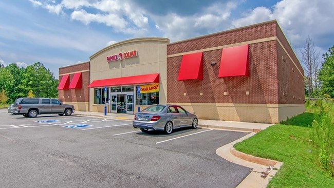
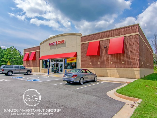
3250 Highway 81 S
0028000000100B00
2.57 AC HWY 81/OAK HILL RD
Wholesaleoutletdiscountstore
Newton
B and X Area of moderate flood hazard, usually the area between the limits of the 100-year and 500-year floods.
Georgia
2025
2.57 AC
2025
Lithonia/Conyers
100902
Atlanta
8,320 SF
Atlanta-Sandy Springs-Roswell, GA
NEARBY LISTINGS FOR SALE OR LEASE
-
-
View all Covington listings for lease on LoopNet.com
DEMOGRAPHICS near 3250 Highway 81 S
1 mile
3 mile
5 mile
2025 Total Population
4,156
31,635
76,058
2030 Population
4,492
34,376
82,108
Pop Growth 2025-2030
+ 8.08%
+ 8.66%
+ 7.95%
Average Age
37
37
38
2025 Total Households
1,400
10,590
26,332
HH Growth 2025-2030
+ 8.21%
+ 8.78%
+ 8.07%
Median Household Inc
$73,009
$76,107
$75,308
Avg Household Size
2.90
2.90
2.80
2025 Avg HH Vehicles
2.00
2.00
2.00
Median Home Value
$289,957
$248,978
$254,632
Median Year Built
1997
2001
1998
Nearby Places
Map Layers
Map Styles
 Street
 Aerial
Layers
 Traffic
 Biking
Places
Listings with unknown addresses are not visible on the map
- Restaurants
- Banks
- Shops
- Fitness
- Groceries
PUBLIC TRANSPORTATION
AIRPORT
Hartsfield - Jackson Atlanta International
Drive
Walk
Distance
Hartsfield - Jackson Atlanta International
55 min
39.3 mi
Freight Ports
Georgia Ports - Savannah
Drive
Walk
Distance
Georgia Ports - Savannah
269 min
237.5 mi
SALE & LEASE HISTORY
LISTING DATE
SALE/LEASE

Sep 27, 2018
For Sale
Mar 31, 2026
For Lease
Mar 31, 2026
For Sale
Nearby Properties
Address
Land Use
TOTAL SIZE
Lot Size
Zoning
Address
Land Use
TOTAL SIZE
Lot Size
Zoning
1,158,095 SF
161.26 AC
Address
Land Use
TOTAL SIZE
Lot Size
Zoning
1,158,095 SF
0.01 AC
Address
Land Use
TOTAL SIZE
Lot Size
Zoning
82,716 SF
21.04 AC
R2
Address
Land Use
TOTAL SIZE
Lot Size
Zoning
65,360 SF
75.51 AC
E6
Address
Land Use
TOTAL SIZE
Lot Size
Zoning
151,955 SF
26.17 AC
R1
Address
Land Use
TOTAL SIZE
Lot Size
Zoning
64,799 SF
19.10 AC
E6
Address
Land Use
TOTAL SIZE
Lot Size
Zoning
66,660 SF
12.80 AC
C1
Address
Land Use
TOTAL SIZE
Lot Size
Zoning
58,892 SF
17.52 AC
E6
Address
Land Use
TOTAL SIZE
Lot Size
Zoning
30,000 SF
11.06 AC
E2
Address
Land Use
TOTAL SIZE
Lot Size
Zoning
1,790 SF
79.74 AC
E2
Address
Land Use
TOTAL SIZE
Lot Size
Zoning
4,576 SF
1.46 AC
Address
Land Use
TOTAL SIZE
Lot Size
Zoning
11,862 SF
1.76 AC
C1
Address
Land Use
TOTAL SIZE
Lot Size
Zoning
14,328 SF
1.20 AC
C1
Address
Land Use
TOTAL SIZE
Lot Size
Zoning
2,858 SF
11 AC
R1
Address
Land Use
TOTAL SIZE
Lot Size
Zoning
383.52 AC
Address
Land Use
TOTAL SIZE
Lot Size
Zoning
30,456 SF
6.99 AC
R2
Address
Land Use
TOTAL SIZE
Lot Size
Zoning
8,000 SF
2.38 AC
C1
Address
Land Use
TOTAL SIZE
Lot Size
Zoning
2,065 SF
15 AC
E2
Address
Land Use
TOTAL SIZE
Lot Size
Zoning
394.98 AC
AR
Address
Land Use
TOTAL SIZE
Lot Size
Zoning
9,000 SF
1.70 AC
R1
Address
Land Use
TOTAL SIZE
Lot Size
Zoning
2,346 SF
1.63 AC
Address
Land Use
TOTAL SIZE
Lot Size
Zoning
7,610 SF
2.28 AC
CG
Address
Land Use
TOTAL SIZE
Lot Size
Zoning
29,450 SF
2.75 AC
C1
Address
Land Use
TOTAL SIZE
Lot Size
Zoning
7,960 SF
1.37 AC
E2
Address
Land Use
TOTAL SIZE
Lot Size
Zoning
3,206 SF
1.45 AC
Address
Land Use
TOTAL SIZE
Lot Size
Zoning
1,036 SF
347.75 AC
AR
Address
Land Use
TOTAL SIZE
Lot Size
Zoning
24,710 SF
19 AC
E2
Address
Land Use
TOTAL SIZE
Lot Size
Zoning
9,348 SF
3 AC
C1
Address
Land Use
TOTAL SIZE
Lot Size
Zoning
4,644 SF
1.73 AC
C1
Address
Land Use
TOTAL SIZE
Lot Size
Zoning
4,826 SF
1.49 AC
C1
The World's #1 Commercial Real Estate Marketplace
Connect with us
© 2026 CoStar Group
The information above has been obtained from sources believed reliable. While we do not doubt its accuracy we have not verified it and make no guarantee, warranty or representation about it. It is your responsibility to independently confirm its accuracy and completeness. Any projections, opinions, assumptions, or estimates used are for example only and do not represent the current or future performance of the property. The value of this transaction to you depends on tax and other factors which should be evaluated by your tax, financial, and legal advisors. You and your advisors should conduct a careful, independent investigation of the property to determine to your satisfaction the suitability of the property for your needs.