Property Record
3250 Rolling Oaks Blvd, Kissimmee, FL 34747


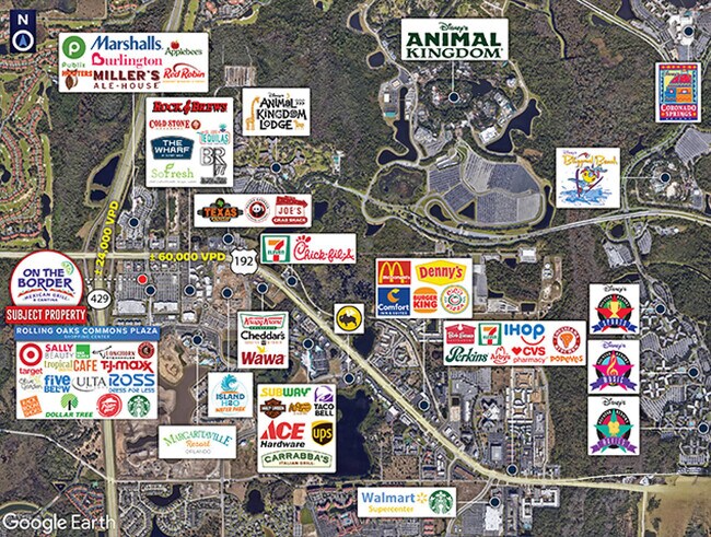
NEARBY LISTINGS FOR SALE OR LEASE
Property Detail
3250 Rolling Oaks Blvd
Orlando-Kissimmee-Sanford, FL
Rolling Oaks Commons Ii
04-25-27-4898-0001-0020
ROLLING OAKS COMMONS II PB 25 PGS 15-17 LOT 2
Restaurantbuilding
Osceola
X
Florida
12105C0125H
2
2024
1.93 AC
2025
Osceola Outlying
040805
Orlando
6,935 SF
DEMOGRAPHICS near 3250 Rolling Oaks Blvd
1 Mile
3 Mile
5 Mile
2024 Total Population
2,847
28,266
94,406
2029 Population
3,595
35,226
115,117
Pop Growth 2024-2029
+ 26.27%
+ 24.62%
+ 21.94%
Average Age
34
37
38
2024 Total Households
1,074
10,598
35,442
HH Growth 2024-2029
+ 26.16%
+ 24.75%
+ 21.82%
Median Household Inc
$56,201
$61,611
$66,805
Avg Household Size
2.60
2.60
2.60
2024 Avg HH Vehicles
2.00
2.00
2.00
Median Home Value
$312,829
$288,441
$295,738
Median Year Built
2002
2007
2005
Nearby Places
Map Layers
Map Styles
 Street
 Aerial
- Restaurants
- Banks
- Shops
- Fitness
- Groceries
PUBLIC TRANSPORTATION
AIRPORT
Orlando International
DRIVE
WALK
Distance
Orlando International
29 min
23.9 mi
SALE & LEASE HISTORY
LISTING DATE
SALE/LEASE

Nov 16, 2016
For Sale
Mar 13, 2025
For Lease
Dec 14, 2016
For Sale
Aug 28, 2023
For Sale
Apr 13, 2017
For Sale
Nearby Properties
Address
Land Use
TOTAL SIZE
Lot Size
Zoning
Address
Land Use
TOTAL SIZE
Lot Size
Zoning
386,104 SF
8.14 AC
Address
Land Use
TOTAL SIZE
Lot Size
Zoning
1,314,060 SF
32.08 AC
P-D
Address
Land Use
TOTAL SIZE
Lot Size
Zoning
1,956,707 SF
209.24 AC
RCID
Address
Land Use
TOTAL SIZE
Lot Size
Zoning
1,353,936 SF
523.88 AC
E
Address
Land Use
TOTAL SIZE
Lot Size
Zoning
1,980,310 SF
140.63 AC
H/R
Address
Land Use
TOTAL SIZE
Lot Size
Zoning
883,200 SF
75.26 AC
P-D
Address
Land Use
TOTAL SIZE
Lot Size
Zoning
1,981,135 SF
2.60 AC
P-D
Address
Land Use
TOTAL SIZE
Lot Size
Zoning
1,906,663 SF
29.75 AC
P-D
Address
Land Use
TOTAL SIZE
Lot Size
Zoning
874,488 SF
159.54 AC
H/R
Address
Land Use
TOTAL SIZE
Lot Size
Zoning
414,620 SF
16.64 AC
P-D
Address
Land Use
TOTAL SIZE
Lot Size
Zoning
283,974 SF
3.23 AC
P-D
Address
Land Use
TOTAL SIZE
Lot Size
Zoning
354,600 SF
12.03 AC
P-D
Address
Land Use
TOTAL SIZE
Lot Size
Zoning
280,327 SF
16.27 AC
OCG
Address
Land Use
TOTAL SIZE
Lot Size
Zoning
55,980 SF
57.91 AC
C
Address
Land Use
TOTAL SIZE
Lot Size
Zoning
457,911 SF
9.60 AC
P-D
Address
Land Use
TOTAL SIZE
Lot Size
Zoning
480,142 SF
29.57 AC
OPD
Address
Land Use
TOTAL SIZE
Lot Size
Zoning
363,694 SF
17.65 AC
Address
Land Use
TOTAL SIZE
Lot Size
Zoning
364,023 SF
18.77 AC
OPD
Address
Land Use
TOTAL SIZE
Lot Size
Zoning
418,368 SF
12.66 AC
Address
Land Use
TOTAL SIZE
Lot Size
Zoning
128,000 SF
19.60 AC
P-D
Address
Land Use
TOTAL SIZE
Lot Size
Zoning
342,019 SF
23 AC
OCG
Address
Land Use
TOTAL SIZE
Lot Size
Zoning
305,617 SF
0.93 AC
P-D
Address
Land Use
TOTAL SIZE
Lot Size
Zoning
306,139 SF
19.77 AC
P-D
Address
Land Use
TOTAL SIZE
Lot Size
Zoning
287,988 SF
P-D
Address
Land Use
TOTAL SIZE
Lot Size
Zoning
357,292 SF
1.34 AC
P-D
Address
Land Use
TOTAL SIZE
Lot Size
Zoning
273,164 SF
P-D
Address
Land Use
TOTAL SIZE
Lot Size
Zoning
59,868 SF
0.81 AC
P-D
Address
Land Use
TOTAL SIZE
Lot Size
Zoning
125,486 SF
30.26 AC
C
Address
Land Use
TOTAL SIZE
Lot Size
Zoning
112,268 SF
14.11 AC
OCG
Address
Land Use
TOTAL SIZE
Lot Size
Zoning
142,828 SF
429.01 AC
P-D
The World's #1 Commercial Real Estate Marketplace
Connect with us
© 2026 CoStar Group
The information above has been obtained from sources believed reliable. While we do not doubt its accuracy we have not verified it and make no guarantee, warranty or representation about it. It is your responsibility to independently confirm its accuracy and completeness. Any projections, opinions, assumptions, or estimates used are for example only and do not represent the current or future performance of the property. The value of this transaction to you depends on tax and other factors which should be evaluated by your tax, financial, and legal advisors. You and your advisors should conduct a careful, independent investigation of the property to determine to your satisfaction the suitability of the property for your needs.