Property Record
3250 Route 9D, Cold Spring, NY 10516
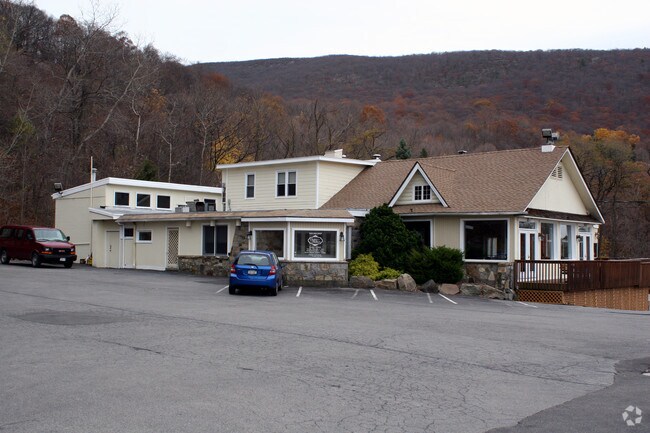

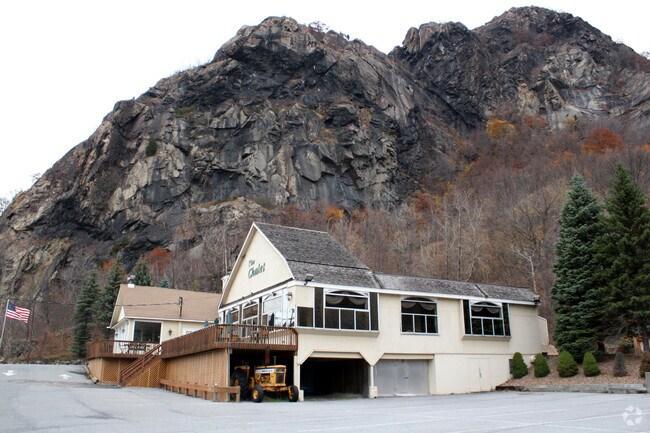

Property Detail
3250 Route 9D
372689-037-000-0002-014-000-0000
LAND & RESTAURANT
Stateproperty
Putnam
R80
New York
B and X Area of moderate flood hazard, usually the area between the limits of the 100-year and 500-year floods.
14.00
2024
2.04 AC
2024
Carmel
010600
Westchester/So Connecticut
15,650 SF
New York-Jersey City-White Plains, NY-NJ
NEARBY LISTINGS FOR SALE OR LEASE
DEMOGRAPHICS near 3250 Route 9D
1 mile
3 mile
5 mile
2025 Total Population
17
11,990
72,461
2030 Population
16
12,246
73,618
Pop Growth 2025-2030
(5.88%)
+ 2.14%
+ 1.60%
Average Age
40
40
39
2025 Total Households
7
4,171
26,416
HH Growth 2025-2030
0.00%
+ 2.28%
+ 1.66%
Median Household Inc
$93,749
$117,883
$88,864
Avg Household Size
2.10
2.50
2.50
2025 Avg HH Vehicles
2.00
2.00
2.00
Median Home Value
$399,999
$508,914
$412,679
Median Year Built
1947
1958
1959
Nearby Places
Map Layers
Map Styles
 Street
 Aerial
Transit
 Traffic
 Biking
Places
Listings with unknown addresses are not visible on the map
- Restaurants
- Banks
- Shops
- Fitness
- Groceries
PUBLIC TRANSPORTATION
COMMUTER RAIL
Breakneck Ridge Station (Hudson Line - Metro-North Commuter Railroad Company (Metro-North))
Drive
Walk
Distance
Breakneck Ridge Station (Hudson Line - Metro-North Commuter Railroad Company (Metro-North))
1 min
17 min
0.8 mi
Cold Spring Station (Hudson Line - Metro-North Commuter Railroad Company (Metro-North))
Drive
Walk
Distance
Cold Spring Station (Hudson Line - Metro-North Commuter Railroad Company (Metro-North))
5 min
2.2 mi
AIRPORT
New York Stewart International
Drive
Walk
Distance
New York Stewart International
31 min
16.4 mi
Westchester County
Drive
Walk
Distance
Westchester County
63 min
39.6 mi
Nearby Properties
Address
Land Use
TOTAL SIZE
Lot Size
Zoning
Address
Land Use
TOTAL SIZE
Lot Size
Zoning
364,010 SF
83 AC
R2
Address
Land Use
TOTAL SIZE
Lot Size
Zoning
Address
Land Use
TOTAL SIZE
Lot Size
Zoning
20,518 SF
1.70 AC
Address
Land Use
TOTAL SIZE
Lot Size
Zoning
100,369 SF
11.96 AC
R10
Address
Land Use
TOTAL SIZE
Lot Size
Zoning
Address
Land Use
TOTAL SIZE
Lot Size
Zoning
50,096 SF
4.80 AC
Address
Land Use
TOTAL SIZE
Lot Size
Zoning
73,224 SF
464.99 AC
R80
Address
Land Use
TOTAL SIZE
Lot Size
Zoning
25.30 AC
R4A
Address
Land Use
TOTAL SIZE
Lot Size
Zoning
42,411 SF
5.17 AC
R10
Address
Land Use
TOTAL SIZE
Lot Size
Zoning
37,616 SF
25.10 AC
Address
Land Use
TOTAL SIZE
Lot Size
Zoning
18,592 SF
26.50 AC
Address
Land Use
TOTAL SIZE
Lot Size
Zoning
40,796 SF
125.03 AC
R80
Address
Land Use
TOTAL SIZE
Lot Size
Zoning
60,076 SF
3.60 AC
02
Address
Land Use
TOTAL SIZE
Lot Size
Zoning
76.06 AC
PI
Address
Land Use
TOTAL SIZE
Lot Size
Zoning
Address
Land Use
TOTAL SIZE
Lot Size
Zoning
477.17 AC
R4A
Address
Land Use
TOTAL SIZE
Lot Size
Zoning
21,120 SF
43.91 AC
R80
Address
Land Use
TOTAL SIZE
Lot Size
Zoning
44.70 AC
02
Address
Land Use
TOTAL SIZE
Lot Size
Zoning
39,971 SF
10.39 AC
R10
Address
Land Use
TOTAL SIZE
Lot Size
Zoning
17,420 SF
21 AC
Address
Land Use
TOTAL SIZE
Lot Size
Zoning
21,276 SF
6.63 AC
RB
Address
Land Use
TOTAL SIZE
Lot Size
Zoning
15,949 SF
40.40 AC
02
Address
Land Use
TOTAL SIZE
Lot Size
Zoning
Address
Land Use
TOTAL SIZE
Lot Size
Zoning
11,480 SF
10.84 AC
R40
Address
Land Use
TOTAL SIZE
Lot Size
Zoning
128.99 AC
RMF5
Address
Land Use
TOTAL SIZE
Lot Size
Zoning
9,308 SF
0.76 AC
Address
Land Use
TOTAL SIZE
Lot Size
Zoning
7,815 SF
13 AC
Address
Land Use
TOTAL SIZE
Lot Size
Zoning
Address
Land Use
TOTAL SIZE
Lot Size
Zoning
62,680 SF
9.10 AC
02
Address
Land Use
TOTAL SIZE
Lot Size
Zoning
10,331 SF
2.20 AC
R3
The World's #1 Commercial Real Estate Marketplace
Connect with us
© 2026 CoStar Group
The information above has been obtained from sources believed reliable. While we do not doubt its accuracy we have not verified it and make no guarantee, warranty or representation about it. It is your responsibility to independently confirm its accuracy and completeness. Any projections, opinions, assumptions, or estimates used are for example only and do not represent the current or future performance of the property. The value of this transaction to you depends on tax and other factors which should be evaluated by your tax, financial, and legal advisors. You and your advisors should conduct a careful, independent investigation of the property to determine to your satisfaction the suitability of the property for your needs.