Property Record
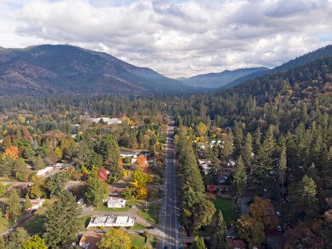
3251 Rogue River Hwy, Grants Pass, OR 97527
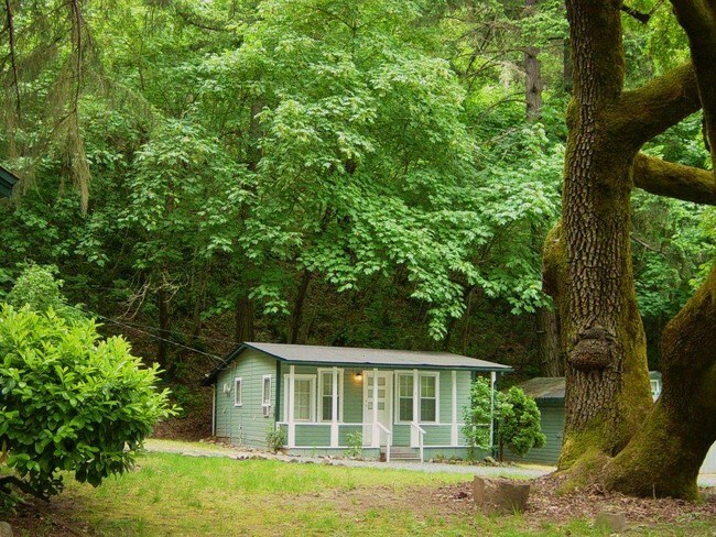

This Property Is For Sale
Property Detail
3251 Rogue River Hwy
R315483
ACRES 8.03
Multifamilydwelling
Josephine
RR5
Oregon
B and X Area of moderate flood hazard, usually the area between the limits of the 100-year and 500-year floods.
8.03 AC
2024
Medford/Grants Pass
2025
Other Market Areas
361302
Grants Pass, OR
6,508 SF
NEARBY LISTINGS FOR SALE OR LEASE
DEMOGRAPHICS near 3251 Rogue River Hwy
1 mile
3 mile
5 mile
2025 Total Population
1,162
21,375
45,313
2030 Population
1,161
21,293
45,006
Pop Growth 2025-2030
(0.09%)
(0.38%)
(0.68%)
Average Age
49
43
44
2025 Total Households
508
8,792
18,398
HH Growth 2025-2030
0.00%
(0.49%)
(0.82%)
Median Household Inc
$62,692
$60,748
$63,882
Avg Household Size
2.30
2.30
2.30
2025 Avg HH Vehicles
2.00
2.00
2.00
Median Home Value
$471,126
$391,327
$389,342
Median Year Built
1976
1976
1979
Nearby Places
Map Layers
Map Styles
 Street
 Aerial
Layers
 Traffic
 Biking
Places
Listings with unknown addresses are not visible on the map
- Restaurants
- Banks
- Shops
- Fitness
- Groceries
PUBLIC TRANSPORTATION
AIRPORT
Rogue Valley International - Medford
Drive
Walk
Distance
Rogue Valley International - Medford
33 min
24.1 mi
Freight Ports
Port of Coos Bay, OR
Drive
Walk
Distance
Port of Coos Bay, OR
190 min
140.9 mi
Nearby Properties
Address
Land Use
TOTAL SIZE
Lot Size
Zoning
Address
Land Use
TOTAL SIZE
Lot Size
Zoning
2,952 SF
2.75 AC
RR1
Address
Land Use
TOTAL SIZE
Lot Size
Zoning
49,752 SF
11.21 AC
R-2
Address
Land Use
TOTAL SIZE
Lot Size
Zoning
13,764 SF
3.32 AC
R-2
Address
Land Use
TOTAL SIZE
Lot Size
Zoning
11.54 AC
I
Address
Land Use
TOTAL SIZE
Lot Size
Zoning
360 SF
18.68 AC
I
Address
Land Use
TOTAL SIZE
Lot Size
Zoning
4,888 SF
2.58 AC
R-4,GC
Address
Land Use
TOTAL SIZE
Lot Size
Zoning
8,706 SF
13.73 AC
GC
Address
Land Use
TOTAL SIZE
Lot Size
Zoning
3.93 AC
R-3
Address
Land Use
TOTAL SIZE
Lot Size
Zoning
Address
Land Use
TOTAL SIZE
Lot Size
Zoning
9.70 AC
BP
Address
Land Use
TOTAL SIZE
Lot Size
Zoning
8.48 AC
BP
Address
Land Use
TOTAL SIZE
Lot Size
Zoning
4,568 SF
5.71 AC
R-2
Address
Land Use
TOTAL SIZE
Lot Size
Zoning
1,792 SF
6.15 AC
R-2
Address
Land Use
TOTAL SIZE
Lot Size
Zoning
66,148 SF
2.63 AC
I
Address
Land Use
TOTAL SIZE
Lot Size
Zoning
47,060 SF
10.65 AC
R-1-6
Address
Land Use
TOTAL SIZE
Lot Size
Zoning
111,774 SF
6.93 AC
R-3
Address
Land Use
TOTAL SIZE
Lot Size
Zoning
142,166 SF
12.41 AC
I
Address
Land Use
TOTAL SIZE
Lot Size
Zoning
9.70 AC
BP
Address
Land Use
TOTAL SIZE
Lot Size
Zoning
115,852 SF
8.79 AC
GC
Address
Land Use
TOTAL SIZE
Lot Size
Zoning
17,350 SF
6.63 AC
BP
Address
Land Use
TOTAL SIZE
Lot Size
Zoning
56,404 SF
2.82 AC
R-3
Address
Land Use
TOTAL SIZE
Lot Size
Zoning
48,520 SF
7.39 AC
R-1-8
Address
Land Use
TOTAL SIZE
Lot Size
Zoning
26,079 SF
6.32 AC
GC
Address
Land Use
TOTAL SIZE
Lot Size
Zoning
8.48 AC
BP
Address
Land Use
TOTAL SIZE
Lot Size
Zoning
61,881 SF
7.49 AC
GC
Address
Land Use
TOTAL SIZE
Lot Size
Zoning
74,976 SF
2.06 AC
R-4
Address
Land Use
TOTAL SIZE
Lot Size
Zoning
5,278 SF
2.72 AC
GC
Address
Land Use
TOTAL SIZE
Lot Size
Zoning
12,407 SF
3.71 AC
R-3
Address
Land Use
TOTAL SIZE
Lot Size
Zoning
126,000 SF
3.47 AC
GC
Address
Land Use
TOTAL SIZE
Lot Size
Zoning
4,680 SF
3.02 AC
R-3
The World's #1 Commercial Real Estate Marketplace
Connect with us
© 2026 CoStar Group
The information above has been obtained from sources believed reliable. While we do not doubt its accuracy we have not verified it and make no guarantee, warranty or representation about it. It is your responsibility to independently confirm its accuracy and completeness. Any projections, opinions, assumptions, or estimates used are for example only and do not represent the current or future performance of the property. The value of this transaction to you depends on tax and other factors which should be evaluated by your tax, financial, and legal advisors. You and your advisors should conduct a careful, independent investigation of the property to determine to your satisfaction the suitability of the property for your needs.