Property Record
3252 Cassopolis St, Elkhart, IN 46514
NEARBY LISTINGS FOR SALE OR LEASE
-
-
View all Elkhart listings for sale on LoopNet.com
Property Detail
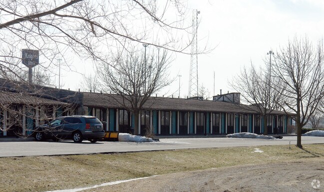
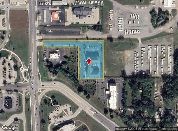
3252 Cassopolis St
Elkhart-Goshen, IN
World Wide Plaza P U D
20-02-20-202-032.000-027
WORLDWIDE PLAZA PUD AMENDMENT LOT 1 (TIF 118)
Hotel
Elkhart
X
Indiana
18039C0126D
1
2024
2.79 AC
2025
South Bend/Elkhart
001701
South Bend/Mishawaka
76,452 SF
DEMOGRAPHICS near 3252 Cassopolis St
1 Mile
3 Mile
5 Mile
2024 Total Population
3,711
24,638
77,325
2029 Population
3,702
24,615
77,488
Pop Growth 2024-2029
(0.24%)
(0.09%)
+ 0.21%
Average Age
40
40
38
2024 Total Households
1,571
10,043
29,565
HH Growth 2024-2029
(0.25%)
(0.12%)
+ 0.22%
Median Household Inc
$53,068
$54,087
$54,569
Avg Household Size
2.40
2.40
2.50
2024 Avg HH Vehicles
2.00
2.00
2.00
Median Home Value
$181,749
$157,105
$158,006
Median Year Built
1986
1978
1972
Nearby Places
Map Layers
Map Styles
 Street
 Aerial
- Restaurants
- Banks
- Shops
- Fitness
- Groceries
PUBLIC TRANSPORTATION
COMMUTER RAIL
DRIVE
WALK
Distance
8 min
4.3 mi
AIRPORT
South Bend International
DRIVE
WALK
Distance
South Bend International
39 min
25.3 mi
Nearby Properties
Address
Land Use
TOTAL SIZE
Lot Size
Zoning
Address
Land Use
TOTAL SIZE
Lot Size
Zoning
384,095 SF
64.77 AC
Address
Land Use
TOTAL SIZE
Lot Size
Zoning
59,994 SF
46.12 AC
ZO01
Address
Land Use
TOTAL SIZE
Lot Size
Zoning
347,814 SF
27.57 AC
ZO01
Address
Land Use
TOTAL SIZE
Lot Size
Zoning
334,473 SF
24.88 AC
ZO01
Address
Land Use
TOTAL SIZE
Lot Size
Zoning
158,688 SF
20.79 AC
ZO01
Address
Land Use
TOTAL SIZE
Lot Size
Zoning
68,943 SF
20.40 AC
ZO01
Address
Land Use
TOTAL SIZE
Lot Size
Zoning
128,225 SF
12.56 AC
ZO01
Address
Land Use
TOTAL SIZE
Lot Size
Zoning
203,685 SF
17.74 AC
ZO01
Address
Land Use
TOTAL SIZE
Lot Size
Zoning
78,006 SF
8.10 AC
ZO01
Address
Land Use
TOTAL SIZE
Lot Size
Zoning
204,010 SF
32.52 AC
ZO01
Address
Land Use
TOTAL SIZE
Lot Size
Zoning
198,093 SF
5.36 AC
ZO01
Address
Land Use
TOTAL SIZE
Lot Size
Zoning
196,080 SF
17.99 AC
ZO01
Address
Land Use
TOTAL SIZE
Lot Size
Zoning
279,045 SF
12.76 AC
ZO01
Address
Land Use
TOTAL SIZE
Lot Size
Zoning
246,553 SF
22.11 AC
ZO01
Address
Land Use
TOTAL SIZE
Lot Size
Zoning
81,452 SF
33.51 AC
ZO01
Address
Land Use
TOTAL SIZE
Lot Size
Zoning
65,387 SF
7.72 AC
ZO01
Address
Land Use
TOTAL SIZE
Lot Size
Zoning
142,932 SF
7.40 AC
ZO01
Address
Land Use
TOTAL SIZE
Lot Size
Zoning
164,420 SF
5.58 AC
ZO01
Address
Land Use
TOTAL SIZE
Lot Size
Zoning
147,726 SF
15.40 AC
ZO01
Address
Land Use
TOTAL SIZE
Lot Size
Zoning
43,839 SF
2.01 AC
ZO01
Address
Land Use
TOTAL SIZE
Lot Size
Zoning
139,274 SF
14.03 AC
ZO01
Address
Land Use
TOTAL SIZE
Lot Size
Zoning
144,000 SF
18.31 AC
ZO01
Address
Land Use
TOTAL SIZE
Lot Size
Zoning
153,910 SF
15.14 AC
Address
Land Use
TOTAL SIZE
Lot Size
Zoning
155,600 SF
10.53 AC
ZO01
Address
Land Use
TOTAL SIZE
Lot Size
Zoning
157,140 SF
19.35 AC
ZO01
Address
Land Use
TOTAL SIZE
Lot Size
Zoning
138,638 SF
3.67 AC
ZO01
Address
Land Use
TOTAL SIZE
Lot Size
Zoning
160,680 SF
21.31 AC
ZO01
Address
Land Use
TOTAL SIZE
Lot Size
Zoning
96,888 SF
3.26 AC
ZO01
Address
Land Use
TOTAL SIZE
Lot Size
Zoning
120,176 SF
10 AC
ZO01
Address
Land Use
TOTAL SIZE
Lot Size
Zoning
178,223 SF
9.83 AC
ZO01
The World's #1 Commercial Real Estate Marketplace
Connect with us
© 2026 CoStar Group
The information above has been obtained from sources believed reliable. While we do not doubt its accuracy we have not verified it and make no guarantee, warranty or representation about it. It is your responsibility to independently confirm its accuracy and completeness. Any projections, opinions, assumptions, or estimates used are for example only and do not represent the current or future performance of the property. The value of this transaction to you depends on tax and other factors which should be evaluated by your tax, financial, and legal advisors. You and your advisors should conduct a careful, independent investigation of the property to determine to your satisfaction the suitability of the property for your needs.