Property Record
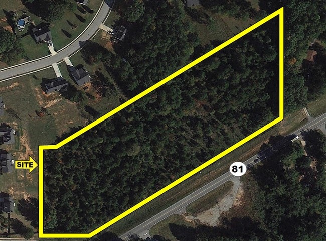
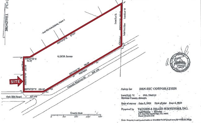
3252 Highway 81 S, Covington, GA 30016

NEARBY LISTINGS FOR SALE OR LEASE
Property Detail
3252 Highway 81 S
Atlanta-Sandy Springs-Roswell, GA
Hwy 81 / Hwy 162 Corridor
0028000000100000
3.568 AC HWY 81/OAK HILL RD
Commercialacreage
Newton
X
Georgia
13217C0115D
3.57 AC
2025
Newton County
2025
Atlanta
100902
DEMOGRAPHICS near 3252 Highway 81 S
1 Mile
3 Mile
5 Mile
2024 Total Population
4,074
30,070
72,753
2029 Population
4,509
33,338
79,921
Pop Growth 2024-2029
+ 10.68%
+ 10.87%
+ 9.85%
Average Age
37
37
37
2024 Total Households
1,377
10,087
25,204
HH Growth 2024-2029
+ 10.97%
+ 11.15%
+ 10.09%
Median Household Inc
$79,644
$73,373
$71,581
Avg Household Size
2.90
2.90
2.80
2024 Avg HH Vehicles
2.00
2.00
2.00
Median Home Value
$182,303
$170,530
$176,598
Median Year Built
1997
2000
1997
Nearby Places
Map Layers
Map Styles
 Street
 Aerial
- Restaurants
- Banks
- Shops
- Fitness
- Groceries
PUBLIC TRANSPORTATION
AIRPORT
Hartsfield - Jackson Atlanta International
DRIVE
WALK
Distance
Hartsfield - Jackson Atlanta International
55 min
39.3 mi
Nearby Properties
Address
Land Use
TOTAL SIZE
Lot Size
Zoning
Address
Land Use
TOTAL SIZE
Lot Size
Zoning
1,158,095 SF
161.26 AC
Address
Land Use
TOTAL SIZE
Lot Size
Zoning
1,158,095 SF
0.01 AC
Address
Land Use
TOTAL SIZE
Lot Size
Zoning
82,716 SF
21.04 AC
R2
Address
Land Use
TOTAL SIZE
Lot Size
Zoning
65,360 SF
75.51 AC
E6
Address
Land Use
TOTAL SIZE
Lot Size
Zoning
151,955 SF
26.17 AC
R1
Address
Land Use
TOTAL SIZE
Lot Size
Zoning
64,799 SF
19.10 AC
E6
Address
Land Use
TOTAL SIZE
Lot Size
Zoning
66,660 SF
12.80 AC
C1
Address
Land Use
TOTAL SIZE
Lot Size
Zoning
58,892 SF
17.52 AC
E6
Address
Land Use
TOTAL SIZE
Lot Size
Zoning
30,000 SF
11.06 AC
E2
Address
Land Use
TOTAL SIZE
Lot Size
Zoning
1,790 SF
79.74 AC
E2
Address
Land Use
TOTAL SIZE
Lot Size
Zoning
4,576 SF
1.46 AC
Address
Land Use
TOTAL SIZE
Lot Size
Zoning
11,862 SF
1.76 AC
C1
Address
Land Use
TOTAL SIZE
Lot Size
Zoning
14,328 SF
1.20 AC
C1
Address
Land Use
TOTAL SIZE
Lot Size
Zoning
383.52 AC
Address
Land Use
TOTAL SIZE
Lot Size
Zoning
30,456 SF
6.99 AC
R2
Address
Land Use
TOTAL SIZE
Lot Size
Zoning
8,000 SF
2.38 AC
C1
Address
Land Use
TOTAL SIZE
Lot Size
Zoning
2,065 SF
15 AC
E2
Address
Land Use
TOTAL SIZE
Lot Size
Zoning
394.98 AC
AR
Address
Land Use
TOTAL SIZE
Lot Size
Zoning
9,000 SF
1.70 AC
R1
Address
Land Use
TOTAL SIZE
Lot Size
Zoning
2,346 SF
1.63 AC
Address
Land Use
TOTAL SIZE
Lot Size
Zoning
29,450 SF
2.75 AC
C1
Address
Land Use
TOTAL SIZE
Lot Size
Zoning
7,960 SF
1.37 AC
E2
Address
Land Use
TOTAL SIZE
Lot Size
Zoning
3,206 SF
1.45 AC
Address
Land Use
TOTAL SIZE
Lot Size
Zoning
1,036 SF
347.75 AC
AR
Address
Land Use
TOTAL SIZE
Lot Size
Zoning
24,710 SF
19 AC
E2
Address
Land Use
TOTAL SIZE
Lot Size
Zoning
4,644 SF
1.73 AC
C1
Address
Land Use
TOTAL SIZE
Lot Size
Zoning
4,826 SF
1.49 AC
C1
Address
Land Use
TOTAL SIZE
Lot Size
Zoning
3,488 SF
1.42 AC
Address
Land Use
TOTAL SIZE
Lot Size
Zoning
25,000 SF
2.26 AC
C1
Address
Land Use
TOTAL SIZE
Lot Size
Zoning
9,100 SF
1.53 AC
R1
The World's #1 Commercial Real Estate Marketplace
Connect with us
© 2025 CoStar Group
The information above has been obtained from sources believed reliable. While we do not doubt its accuracy we have not verified it and make no guarantee, warranty or representation about it. It is your responsibility to independently confirm its accuracy and completeness. Any projections, opinions, assumptions, or estimates used are for example only and do not represent the current or future performance of the property. The value of this transaction to you depends on tax and other factors which should be evaluated by your tax, financial, and legal advisors. You and your advisors should conduct a careful, independent investigation of the property to determine to your satisfaction the suitability of the property for your needs.