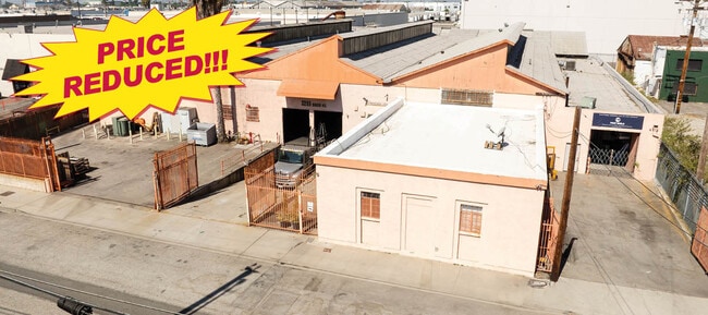
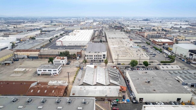
Property Record
3255 Saco St, Vernon, CA 90058


Save to a Folder
{{folder.Name}}
{{folder.ListingIds.length}} Properties
{{folder.ListingIds.length}} Property
Create a New Folder
Property Detail
3255 Saco St
6302-010-003
0.98 MORE OR LESS AC COM S 0 2930 E 340.58 FT AND S 89 3230 W 255.88 FT FROM NE COR OF LOT 2 A L ROSS TRACT TH S 0 2930 E 147.59 FT TH SW ON A CURVE CONCAVE TO SE RADIUS EQUALS 383.07 FT TRACT AND PART OF LOT A TRACT # 1281
Lightindustrial
Los Angeles
VEM*
California
B and X Area of moderate flood hazard, usually the area between the limits of the 100-year and 500-year floods.
2
2025
0.86 AC
2025
Vernon
980016
Los Angeles
44,331 SF
Los Angeles-Long Beach-Glendale, CA
NEARBY LISTINGS FOR SALE OR LEASE
DEMOGRAPHICS near 3255 Saco St
1 mile
3 mile
5 mile
2025 Total Population
12,060
356,600
1,166,659
2030 Population
11,870
350,927
1,150,401
Pop Growth 2025-2030
(1.58%)
(1.59%)
(1.39%)
Average Age
34
36
37
2025 Total Households
2,627
105,320
348,734
HH Growth 2025-2030
(1.83%)
(1.33%)
(1.26%)
Median Household Inc
$56,687
$56,893
$58,561
Avg Household Size
4.20
3.10
3.10
2025 Avg HH Vehicles
2.00
1.00
2.00
Median Home Value
$611,776
$692,814
$707,619
Median Year Built
1949
1956
1955
Nearby Places
Map Layers
Map Styles
 Street
 Aerial
Layers
 Traffic
 Biking
Places
Listings with unknown addresses are not visible on the map
- Restaurants
- Banks
- Shops
- Fitness
- Groceries
PUBLIC TRANSPORTATION
COMMUTER RAIL
Drive
Walk
Distance
9 min
3.7 mi
Union Station (91 Line - Southern California Regional Rail Authority (Metrolink), Antelope Valley Line - Southern California Regional Rail Authority (Metrolink), Orange County Line - Southern California Regional Rail Authority (Metrolink), Riverside Line - Southern California Regional Rail Authority (Metrolink), San Bernardino Line - Southern California Regional Rail Authority (Metrolink), Ventura County Line - Southern California Regional Rail Authority (Metrolink))
Drive
Walk
Distance
Union Station (91 Line - Southern California Regional Rail Authority (Metrolink), Antelope Valley Line - Southern California Regional Rail Authority (Metrolink), Orange County Line - Southern California Regional Rail Authority (Metrolink), Riverside Line - Southern California Regional Rail Authority (Metrolink), San Bernardino Line - Southern California Regional Rail Authority (Metrolink), Ventura County Line - Southern California Regional Rail Authority (Metrolink))
12 min
4.0 mi
AIRPORT
Los Angeles International
Drive
Walk
Distance
Los Angeles International
26 min
13.8 mi
Long Beach (Daugherty Field)
Drive
Walk
Distance
Long Beach (Daugherty Field)
30 min
18.7 mi
Bob Hope
Drive
Walk
Distance
Bob Hope
30 min
20.7 mi
SALE & LEASE HISTORY
LISTING DATE
SALE/LEASE

Oct 09, 2025
For Sale
Oct 08, 2025
For Lease
Nov 06, 2023
For Sale
Jul 10, 2024
For Sale
Nearby Properties
Address
Land Use
TOTAL SIZE
Lot Size
Zoning
Address
Land Use
TOTAL SIZE
Lot Size
Zoning
1,462,729 SF
1.39 AC
LAC2
Address
Land Use
TOTAL SIZE
Lot Size
Zoning
717,065 SF
0.99 AC
LAC2
Address
Land Use
TOTAL SIZE
Lot Size
Zoning
200,811 SF
4.59 AC
LALASED
Address
Land Use
TOTAL SIZE
Lot Size
Zoning
1,178,786 SF
3.89 AC
LAC2
Address
Land Use
TOTAL SIZE
Lot Size
Zoning
764,804 SF
1.48 AC
Address
Land Use
TOTAL SIZE
Lot Size
Zoning
634,863 SF
2.97 AC
LAC2-4D
Address
Land Use
TOTAL SIZE
Lot Size
Zoning
420,864 SF
63.07 AC
LAUSC-1A
Address
Land Use
TOTAL SIZE
Lot Size
Zoning
574,047 SF
1.70 AC
LAR5
Address
Land Use
TOTAL SIZE
Lot Size
Zoning
773,409 SF
1.39 AC
LAC4
Address
Land Use
TOTAL SIZE
Lot Size
Zoning
2,697,158 SF
20.18 AC
LAM2
Address
Land Use
TOTAL SIZE
Lot Size
Zoning
256,059 SF
Address
Land Use
TOTAL SIZE
Lot Size
Zoning
581,956 SF
0.89 AC
LAR5
Address
Land Use
TOTAL SIZE
Lot Size
Zoning
1,207,589 SF
1.01 AC
LAC2
Address
Land Use
TOTAL SIZE
Lot Size
Zoning
387,421 SF
1.08 AC
LAR5
Address
Land Use
TOTAL SIZE
Lot Size
Zoning
195,675 SF
LAC2
Address
Land Use
TOTAL SIZE
Lot Size
Zoning
635,233 SF
12.02 AC
LAR5
Address
Land Use
TOTAL SIZE
Lot Size
Zoning
377,377 SF
0.65 AC
LAC2
Address
Land Use
TOTAL SIZE
Lot Size
Zoning
364,997 SF
1.24 AC
LAR5
Address
Land Use
TOTAL SIZE
Lot Size
Zoning
50,048 SF
1.16 AC
LAR5
Address
Land Use
TOTAL SIZE
Lot Size
Zoning
298,630 SF
4.64 AC
LAUSC-1B
Address
Land Use
TOTAL SIZE
Lot Size
Zoning
461,090 SF
0.47 AC
LAC2
Address
Land Use
TOTAL SIZE
Lot Size
Zoning
329,487 SF
0.94 AC
LAC2
Address
Land Use
TOTAL SIZE
Lot Size
Zoning
466,058 SF
2.54 AC
Address
Land Use
TOTAL SIZE
Lot Size
Zoning
320,925 SF
0.88 AC
LAC2
Address
Land Use
TOTAL SIZE
Lot Size
Zoning
444,139 SF
3.63 AC
LAM3
Address
Land Use
TOTAL SIZE
Lot Size
Zoning
9.17 AC
LALASED
Address
Land Use
TOTAL SIZE
Lot Size
Zoning
448,914 SF
2.67 AC
LAC2
Address
Land Use
TOTAL SIZE
Lot Size
Zoning
311,717 SF
1.45 AC
LAR5
Address
Land Use
TOTAL SIZE
Lot Size
Zoning
274,675 SF
1.34 AC
LAR5
Address
Land Use
TOTAL SIZE
Lot Size
Zoning
479,272 SF
16.14 AC
LAM3
The World's #1 Commercial Real Estate Marketplace
Connect with us
© 2026 CoStar Group
The information above has been obtained from sources believed reliable. While we do not doubt its accuracy we have not verified it and make no guarantee, warranty or representation about it. It is your responsibility to independently confirm its accuracy and completeness. Any projections, opinions, assumptions, or estimates used are for example only and do not represent the current or future performance of the property. The value of this transaction to you depends on tax and other factors which should be evaluated by your tax, financial, and legal advisors. You and your advisors should conduct a careful, independent investigation of the property to determine to your satisfaction the suitability of the property for your needs.