Property Record
32600 N Us Highway 12, Ingleside, IL 60041

Current Lease Availabilities
NEARBY LISTINGS FOR SALE OR LEASE
-
-
View all Ingleside listings for lease on LoopNet.com
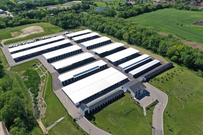
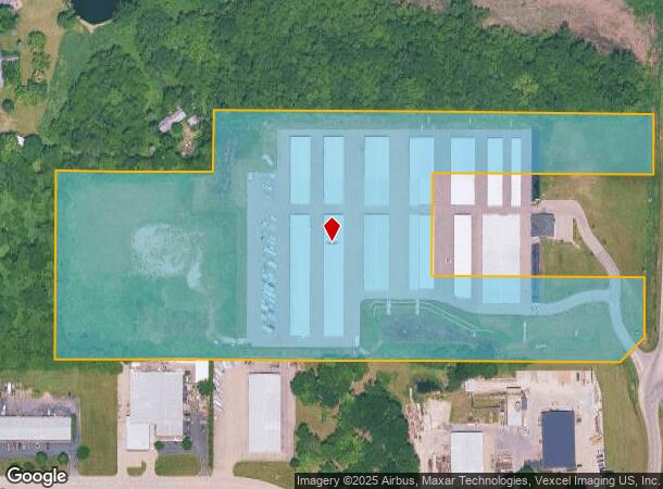
Property Detail
32600 N Us Highway 12
Chicago-Naperville-Elgin, IL-IN
Chain O Lakes Super Storage Subdivision
05-34-102-001
CHAIN-O-LAKES SUPER STORAGE SUBDIVISION; LOT 1 (EX N 273? OF S 500? (EX W 1005?))
Commercialbuilding
Lake
X
Illinois
17097C0108K
1
2023
18.82 AC
2024
Central Northwest
860905
Chicago
DEMOGRAPHICS near 32600 N Us Highway 12
1 mile
3 mile
5 mile
2024 Total Population
3,537
25,056
101,342
2029 Population
3,688
25,048
100,844
Pop Growth 2024-2029
+ 4.27%
(0.03%)
(0.49%)
Average Age
38
39
39
2024 Total Households
1,451
9,337
36,892
HH Growth 2024-2029
+ 4.20%
+ 0.09%
(0.43%)
Median Household Inc
$95,070
$101,062
$84,829
Avg Household Size
2.40
2.70
2.70
2024 Avg HH Vehicles
2.00
2.00
2.00
Median Home Value
$221,842
$239,072
$219,739
Median Year Built
1997
1999
1988
Nearby Places
Map Layers
Map Styles
 Street
 Aerial
Transit
 Traffic
 Biking
Places
Listings with unknown addresses are not visible on the map
- Restaurants
- Banks
- Shops
- Fitness
- Groceries
PUBLIC TRANSPORTATION
COMMUTER RAIL
Ingleside Station (Milwaukee District North Line - Northeast Illinois Regional Commuter Railroad (Metra))
Drive
Walk
Distance
Ingleside Station (Milwaukee District North Line - Northeast Illinois Regional Commuter Railroad (Metra))
11 min
4.7 mi
Long Lake Station (Milwaukee District North Line - Northeast Illinois Regional Commuter Railroad (Metra))
Drive
Walk
Distance
Long Lake Station (Milwaukee District North Line - Northeast Illinois Regional Commuter Railroad (Metra))
11 min
5.1 mi
AIRPORT
Chicago O'Hare International
Drive
Walk
Distance
Chicago O'Hare International
53 min
37.2 mi
Freight Ports
Port Milwaukee
Drive
Walk
Distance
Port Milwaukee
80 min
61.8 mi
Nearby Properties
Address
Land Use
TOTAL SIZE
Lot Size
Zoning
Address
Land Use
TOTAL SIZE
Lot Size
Zoning
12.28 AC
Address
Land Use
TOTAL SIZE
Lot Size
Zoning
30.60 AC
Address
Land Use
TOTAL SIZE
Lot Size
Zoning
6.18 AC
Address
Land Use
TOTAL SIZE
Lot Size
Zoning
10.91 AC
Address
Land Use
TOTAL SIZE
Lot Size
Zoning
83.45 AC
Address
Land Use
TOTAL SIZE
Lot Size
Zoning
Address
Land Use
TOTAL SIZE
Lot Size
Zoning
241,227 SF
15.79 AC
Address
Land Use
TOTAL SIZE
Lot Size
Zoning
163,715 SF
35.43 AC
Address
Land Use
TOTAL SIZE
Lot Size
Zoning
26.09 AC
Address
Land Use
TOTAL SIZE
Lot Size
Zoning
32.23 AC
Address
Land Use
TOTAL SIZE
Lot Size
Zoning
25.89 AC
Address
Land Use
TOTAL SIZE
Lot Size
Zoning
12.56 AC
Address
Land Use
TOTAL SIZE
Lot Size
Zoning
11.05 AC
Address
Land Use
TOTAL SIZE
Lot Size
Zoning
4.04 AC
Address
Land Use
TOTAL SIZE
Lot Size
Zoning
Address
Land Use
TOTAL SIZE
Lot Size
Zoning
20.47 AC
Address
Land Use
TOTAL SIZE
Lot Size
Zoning
448,000 SF
8.28 AC
Address
Land Use
TOTAL SIZE
Lot Size
Zoning
1,525,750 SF
7.55 AC
Address
Land Use
TOTAL SIZE
Lot Size
Zoning
302,400 SF
7.37 AC
Address
Land Use
TOTAL SIZE
Lot Size
Zoning
81,478 SF
9.25 AC
Address
Land Use
TOTAL SIZE
Lot Size
Zoning
Address
Land Use
TOTAL SIZE
Lot Size
Zoning
26,896 SF
4.03 AC
Address
Land Use
TOTAL SIZE
Lot Size
Zoning
20,403 SF
6.47 AC
Address
Land Use
TOTAL SIZE
Lot Size
Zoning
Address
Land Use
TOTAL SIZE
Lot Size
Zoning
Address
Land Use
TOTAL SIZE
Lot Size
Zoning
2.28 AC
Address
Land Use
TOTAL SIZE
Lot Size
Zoning
23,640 SF
1.26 AC
Address
Land Use
TOTAL SIZE
Lot Size
Zoning
24.25 AC
Address
Land Use
TOTAL SIZE
Lot Size
Zoning
5,398 SF
38 AC
The World's #1 Commercial Real Estate Marketplace
Connect with us
© 2026 CoStar Group
The information above has been obtained from sources believed reliable. While we do not doubt its accuracy we have not verified it and make no guarantee, warranty or representation about it. It is your responsibility to independently confirm its accuracy and completeness. Any projections, opinions, assumptions, or estimates used are for example only and do not represent the current or future performance of the property. The value of this transaction to you depends on tax and other factors which should be evaluated by your tax, financial, and legal advisors. You and your advisors should conduct a careful, independent investigation of the property to determine to your satisfaction the suitability of the property for your needs.