Property Record
3256 Main St, Barnstable, MA 02630
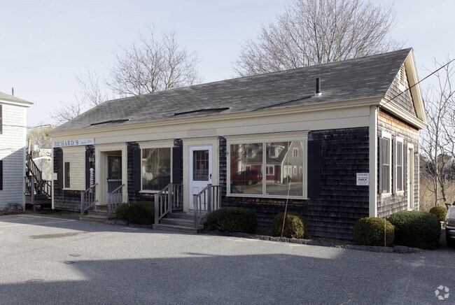

Property Detail
3256 Main St
BARN-000299-000000-000033
BARNSTABLE
Officebuilding
Massachusetts
VB
33
AE The base floodplain where base flood elevations are provided. AE Zones are now used on new format FIRMs instead of A1-A30 Zones.
0.13 AC
2025
Cape Cod
2025
Other Market Areas
012200
Barnstable Town, MA
1,005 SF
NEARBY LISTINGS FOR SALE OR LEASE
DEMOGRAPHICS near 3256 Main St
1 mile
3 mile
5 mile
2025 Total Population
1,345
10,312
43,906
2030 Population
1,243
10,004
43,179
Pop Growth 2025-2030
(7.58%)
(2.99%)
(1.66%)
Average Age
52
46
47
2025 Total Households
606
4,209
18,651
HH Growth 2025-2030
(8.25%)
(3.37%)
(1.86%)
Median Household Inc
$123,822
$87,329
$88,276
Avg Household Size
2.20
2.30
2.20
2025 Avg HH Vehicles
2.00
2.00
2.00
Median Home Value
$766,187
$645,324
$582,585
Median Year Built
1981
1979
1976
Nearby Places
Map Layers
Map Styles
 Street
 Aerial
Transit
 Traffic
 Biking
Places
Listings with unknown addresses are not visible on the map
- Restaurants
- Banks
- Shops
- Fitness
- Groceries
PUBLIC TRANSPORTATION
COMMUTER RAIL
Drive
Walk
Distance
9 min
4.2 mi
AIRPORT
Martha's Vineyard
Drive
Walk
Distance
Martha's Vineyard
106 min
39.8 mi
Freight Ports
Port of New Bedford Harbor
Drive
Walk
Distance
Port of New Bedford Harbor
68 min
48.2 mi
SALE & LEASE HISTORY
LISTING DATE
SALE/LEASE

Jan 21, 2022
For Sale
Nearby Properties
Address
Land Use
TOTAL SIZE
Lot Size
Zoning
Address
Land Use
TOTAL SIZE
Lot Size
Zoning
44 AC
RG;RF
Address
Land Use
TOTAL SIZE
Lot Size
Zoning
10.68 AC
Address
Land Use
TOTAL SIZE
Lot Size
Zoning
25.88 AC
HB;B
Address
Land Use
TOTAL SIZE
Lot Size
Zoning
298,272 SF
9.34 AC
IN
Address
Land Use
TOTAL SIZE
Lot Size
Zoning
17.95 AC
VB-A;R
Address
Land Use
TOTAL SIZE
Lot Size
Zoning
14.34 AC
B;IND
Address
Land Use
TOTAL SIZE
Lot Size
Zoning
30,000 SF
8.48 AC
HB;RF-
Address
Land Use
TOTAL SIZE
Lot Size
Zoning
82.38 AC
RC-1;R
Address
Land Use
TOTAL SIZE
Lot Size
Zoning
253,562 SF
12.54 AC
RC-1;H
Address
Land Use
TOTAL SIZE
Lot Size
Zoning
12.82 AC
B;HB
Address
Land Use
TOTAL SIZE
Lot Size
Zoning
43.50 AC
IN
Address
Land Use
TOTAL SIZE
Lot Size
Zoning
54,172 SF
17.97 AC
IND;B;
Address
Land Use
TOTAL SIZE
Lot Size
Zoning
67,000 SF
9.15 AC
HB;B
Address
Land Use
TOTAL SIZE
Lot Size
Zoning
117,584 SF
9.68 AC
IND;B
Address
Land Use
TOTAL SIZE
Lot Size
Zoning
32.95 AC
IN
Address
Land Use
TOTAL SIZE
Lot Size
Zoning
106,197 SF
8.13 AC
Address
Land Use
TOTAL SIZE
Lot Size
Zoning
37,169 SF
8.71 AC
RC-1;H
Address
Land Use
TOTAL SIZE
Lot Size
Zoning
167,800 SF
9.73 AC
IN
Address
Land Use
TOTAL SIZE
Lot Size
Zoning
90,837 SF
11.66 AC
IN
Address
Land Use
TOTAL SIZE
Lot Size
Zoning
13.46 AC
IN
Address
Land Use
TOTAL SIZE
Lot Size
Zoning
118,274 SF
7.42 AC
Address
Land Use
TOTAL SIZE
Lot Size
Zoning
99,248 SF
4.73 AC
HB;B
Address
Land Use
TOTAL SIZE
Lot Size
Zoning
54,688 SF
10.02 AC
B;RG;R
Address
Land Use
TOTAL SIZE
Lot Size
Zoning
36,536 SF
36.91 AC
RG;RF-
Address
Land Use
TOTAL SIZE
Lot Size
Zoning
8.09 AC
Address
Land Use
TOTAL SIZE
Lot Size
Zoning
16.63 AC
IN
Address
Land Use
TOTAL SIZE
Lot Size
Zoning
74,841 SF
6.45 AC
HB;B
Address
Land Use
TOTAL SIZE
Lot Size
Zoning
80,464 SF
3.50 AC
HB;B
Address
Land Use
TOTAL SIZE
Lot Size
Zoning
2,084 SF
20.03 AC
Address
Land Use
TOTAL SIZE
Lot Size
Zoning
110.62 AC
RF-1;R
The World's #1 Commercial Real Estate Marketplace
Connect with us
© 2026 CoStar Group
The information above has been obtained from sources believed reliable. While we do not doubt its accuracy we have not verified it and make no guarantee, warranty or representation about it. It is your responsibility to independently confirm its accuracy and completeness. Any projections, opinions, assumptions, or estimates used are for example only and do not represent the current or future performance of the property. The value of this transaction to you depends on tax and other factors which should be evaluated by your tax, financial, and legal advisors. You and your advisors should conduct a careful, independent investigation of the property to determine to your satisfaction the suitability of the property for your needs.