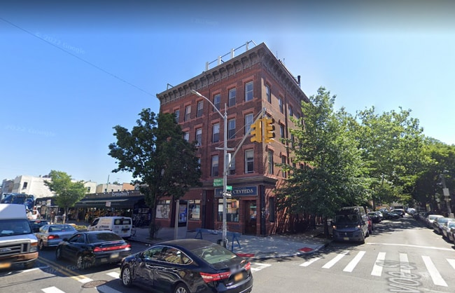
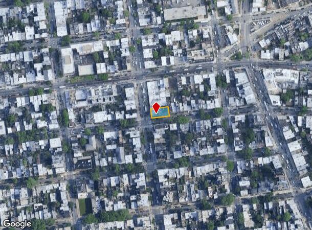
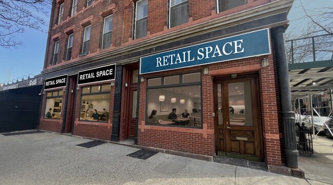
Property Record
326 Graham Ave, Brooklyn, NY 11211

NEARBY LISTINGS FOR SALE OR LEASE
Property Detail
326 Graham Ave
02765-0001
Kings
Apartment
New York
X
1
3604970204F
0.12 AC
2024
Williamsburg
2025
Long Island (New York)
049700
New York-Jersey City-White Plains, NY-NJ
12,000 SF
DEMOGRAPHICS near 326 Graham Ave
1 mile
3 mile
5 mile
2024 Total Population
141,618
1,256,968
3,219,015
2029 Population
135,902
1,186,300
3,020,925
Pop Growth 2024-2029
(4.04%)
(5.62%)
(6.15%)
Average Age
36
38
39
2024 Total Households
59,036
536,976
1,372,168
HH Growth 2024-2029
(4.61%)
(5.98%)
(6.44%)
Median Household Inc
$85,440
$84,722
$87,093
Avg Household Size
2.30
2.20
2.20
2024 Avg HH Vehicles
.00
.00
.00
Median Home Value
$1,009,272
$900,968
$875,934
Median Year Built
1957
1950
1951
Nearby Places
Map Layers
Map Styles
 Street
 Aerial
Transit
 Traffic
 Biking
Places
Listings with unknown addresses are not visible on the map
- Restaurants
- Banks
- Shops
- Fitness
- Groceries
PUBLIC TRANSPORTATION
TRANSIT/SUBWAY
Graham Avenue (L - New York MTA Subway (The Subway))
Drive
Walk
Distance
Graham Avenue (L - New York MTA Subway (The Subway))
0 min
1 min
0.1 mi
Grand Street (L Line) (L - New York MTA Subway (The Subway))
Drive
Walk
Distance
Grand Street (L Line) (L - New York MTA Subway (The Subway))
1 min
5 min
0.3 mi
Lorimer Street (L Line) (L - New York MTA Subway (The Subway))
Drive
Walk
Distance
Lorimer Street (L Line) (L - New York MTA Subway (The Subway))
1 min
6 min
0.3 mi
Metropolitan Avenue (G - New York MTA Subway (The Subway))
Drive
Walk
Distance
Metropolitan Avenue (G - New York MTA Subway (The Subway))
1 min
8 min
0.4 mi
Montrose Avenue (L - New York MTA Subway (The Subway))
Drive
Walk
Distance
Montrose Avenue (L - New York MTA Subway (The Subway))
2 min
11 min
0.6 mi
COMMUTER RAIL
Hunterspoint Avenue Station (Hempstead Branch - Long Island Rail Road, Oyster Bay Branch - Long Island Rail Road)
Drive
Walk
Distance
Hunterspoint Avenue Station (Hempstead Branch - Long Island Rail Road, Oyster Bay Branch - Long Island Rail Road)
7 min
2.4 mi
Long Island City Station (Hempstead Branch - Long Island Rail Road)
Drive
Walk
Distance
Long Island City Station (Hempstead Branch - Long Island Rail Road)
8 min
2.7 mi
AIRPORT
LaGuardia
Drive
Walk
Distance
LaGuardia
14 min
7.1 mi
John F Kennedy International
Drive
Walk
Distance
John F Kennedy International
23 min
12.6 mi
Newark Liberty International
Drive
Walk
Distance
Newark Liberty International
27 min
15.3 mi
Freight Ports
NY - Red Hook Container Terminal
Drive
Walk
Distance
NY - Red Hook Container Terminal
10 min
5.1 mi
SALE & LEASE HISTORY
LISTING DATE
SALE/LEASE

Sep 23, 2016
For Sale
Nov 15, 2016
For Lease
Jul 20, 2023
For Sale
Nearby Properties
Address
Land Use
TOTAL SIZE
Lot Size
Zoning
Address
Land Use
TOTAL SIZE
Lot Size
Zoning
8,462,176 SF
61.41 AC
R7-2
Address
Land Use
TOTAL SIZE
Lot Size
Zoning
2,812,739 SF
2.10 AC
C5-3
Address
Land Use
TOTAL SIZE
Lot Size
Zoning
2,400,000 SF
15.14 AC
C5-2
Address
Land Use
TOTAL SIZE
Lot Size
Zoning
2,124,441 SF
17.29 AC
R8
Address
Land Use
TOTAL SIZE
Lot Size
Zoning
1,233,394 SF
1.78 AC
C5-3
Address
Land Use
TOTAL SIZE
Lot Size
Zoning
1,104,505 SF
2.32 AC
C4-7
Address
Land Use
TOTAL SIZE
Lot Size
Zoning
940,000 SF
1.44 AC
C6-2
Address
Land Use
TOTAL SIZE
Lot Size
Zoning
5.12 AC
C6-1G
Address
Land Use
TOTAL SIZE
Lot Size
Zoning
5.12 AC
C6-1G
Address
Land Use
TOTAL SIZE
Lot Size
Zoning
5.12 AC
C6-1G
Address
Land Use
TOTAL SIZE
Lot Size
Zoning
5.12 AC
C6-1G
Address
Land Use
TOTAL SIZE
Lot Size
Zoning
5.12 AC
C6-1G
Address
Land Use
TOTAL SIZE
Lot Size
Zoning
5.12 AC
C6-1G
Address
Land Use
TOTAL SIZE
Lot Size
Zoning
5.12 AC
C6-1G
Address
Land Use
TOTAL SIZE
Lot Size
Zoning
5.12 AC
C6-1G
Address
Land Use
TOTAL SIZE
Lot Size
Zoning
5.12 AC
C6-1G
Address
Land Use
TOTAL SIZE
Lot Size
Zoning
5.12 AC
C6-1G
Address
Land Use
TOTAL SIZE
Lot Size
Zoning
5.12 AC
C6-1G
Address
Land Use
TOTAL SIZE
Lot Size
Zoning
5.12 AC
C6-1G
Address
Land Use
TOTAL SIZE
Lot Size
Zoning
5.12 AC
C6-1G
Address
Land Use
TOTAL SIZE
Lot Size
Zoning
5.12 AC
C6-1G
Address
Land Use
TOTAL SIZE
Lot Size
Zoning
5.12 AC
C6-1G
Address
Land Use
TOTAL SIZE
Lot Size
Zoning
5.12 AC
C6-1G
Address
Land Use
TOTAL SIZE
Lot Size
Zoning
5.12 AC
C6-1G
Address
Land Use
TOTAL SIZE
Lot Size
Zoning
5.12 AC
C6-1G
Address
Land Use
TOTAL SIZE
Lot Size
Zoning
5.12 AC
C6-1G
Address
Land Use
TOTAL SIZE
Lot Size
Zoning
5.12 AC
C6-1G
Address
Land Use
TOTAL SIZE
Lot Size
Zoning
5.12 AC
C6-1G
Address
Land Use
TOTAL SIZE
Lot Size
Zoning
5.12 AC
C6-1G
Address
Land Use
TOTAL SIZE
Lot Size
Zoning
5.12 AC
C6-1G
The World's #1 Commercial Real Estate Marketplace
Connect with us
© 2026 CoStar Group
The information above has been obtained from sources believed reliable. While we do not doubt its accuracy we have not verified it and make no guarantee, warranty or representation about it. It is your responsibility to independently confirm its accuracy and completeness. Any projections, opinions, assumptions, or estimates used are for example only and do not represent the current or future performance of the property. The value of this transaction to you depends on tax and other factors which should be evaluated by your tax, financial, and legal advisors. You and your advisors should conduct a careful, independent investigation of the property to determine to your satisfaction the suitability of the property for your needs.