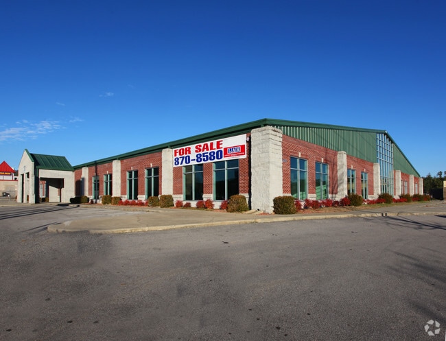
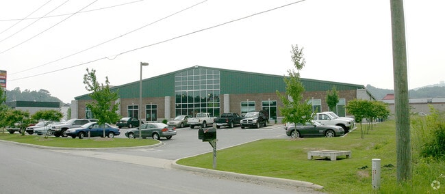
Property Record
3260 Morrow Rd, Birmingham, AL 35235


NEARBY LISTINGS FOR SALE OR LEASE
Property Detail
3260 Morrow Rd
Birmingham, AL
Cole-Ledbetter Llc Com 4A
12-00-33-4-000-013.008
LOT 8 COLE- LEDBETTER LLC COMMERCIAL SUB 4TH ADD 197/53
Storebuilding
Jefferson
X
Alabama
01073C0407J
8
2023
1.49 AC
2024
Trussville
011108
Birmingham
28,000 SF
DEMOGRAPHICS near 3260 Morrow Rd
1 Mile
3 Mile
5 Mile
2024 Total Population
1,161
31,869
87,740
2029 Population
1,136
31,124
85,831
Pop Growth 2024-2029
(2.15%)
(2.34%)
(2.18%)
Average Age
37
39
38
2024 Total Households
542
12,293
33,229
HH Growth 2024-2029
(2.21%)
(2.41%)
(2.25%)
Median Household Inc
$54,494
$59,596
$55,462
Avg Household Size
2.10
2.50
2.50
2024 Avg HH Vehicles
1.00
2.00
2.00
Median Home Value
$122,580
$173,028
$163,449
Median Year Built
1995
1976
1975
Nearby Places
Map Layers
Map Styles
 Street
 Aerial
- Restaurants
- Banks
- Shops
- Fitness
- Groceries
PUBLIC TRANSPORTATION
AIRPORT
Birmingham-Shuttlesworth International
DRIVE
WALK
Distance
Birmingham-Shuttlesworth International
13 min
9.2 mi
Freight Ports
Port of Mobile
DRIVE
WALK
Distance
Port of Mobile
287 min
263.6 mi
SALE & LEASE HISTORY
LISTING DATE
SALE/LEASE

Sep 29, 2021
For Sale
Feb 10, 2025
For Lease
Feb 10, 2025
For Sale
Nearby Properties
Address
Land Use
TOTAL SIZE
Lot Size
Zoning
Address
Land Use
TOTAL SIZE
Lot Size
Zoning
152,664 SF
12.44 AC
CO&I
Address
Land Use
TOTAL SIZE
Lot Size
Zoning
326,294 SF
25.99 AC
R4&U
Address
Land Use
TOTAL SIZE
Lot Size
Zoning
346,184 SF
21.75 AC
I2
Address
Land Use
TOTAL SIZE
Lot Size
Zoning
128,233 SF
CO&I
Address
Land Use
TOTAL SIZE
Lot Size
Zoning
155,845 SF
17 AC
C2
Address
Land Use
TOTAL SIZE
Lot Size
Zoning
137,168 SF
63 AC
A1
Address
Land Use
TOTAL SIZE
Lot Size
Zoning
150,160 SF
12 AC
INST
Address
Land Use
TOTAL SIZE
Lot Size
Zoning
144,921 SF
9 AC
R4
Address
Land Use
TOTAL SIZE
Lot Size
Zoning
87,863 SF
13.20 AC
PUD
Address
Land Use
TOTAL SIZE
Lot Size
Zoning
1 SF
7.08 AC
CB2
Address
Land Use
TOTAL SIZE
Lot Size
Zoning
94,262 SF
17.30 AC
C-2
Address
Land Use
TOTAL SIZE
Lot Size
Zoning
58,509 SF
CO&I
Address
Land Use
TOTAL SIZE
Lot Size
Zoning
207,383 SF
17 AC
CR5
Address
Land Use
TOTAL SIZE
Lot Size
Zoning
39,890 SF
7.10 AC
R8
Address
Land Use
TOTAL SIZE
Lot Size
Zoning
57,296 SF
CO&I
Address
Land Use
TOTAL SIZE
Lot Size
Zoning
112,806 SF
2.04 AC
R2
Address
Land Use
TOTAL SIZE
Lot Size
Zoning
178,988 SF
8.29 AC
CR5
Address
Land Use
TOTAL SIZE
Lot Size
Zoning
194,730 SF
25 AC
I-1
Address
Land Use
TOTAL SIZE
Lot Size
Zoning
149,773 SF
7.30 AC
CR5
Address
Land Use
TOTAL SIZE
Lot Size
Zoning
176,232 SF
5.20 AC
C2
Address
Land Use
TOTAL SIZE
Lot Size
Zoning
110,776 SF
11.10 AC
C2
Address
Land Use
TOTAL SIZE
Lot Size
Zoning
95,172 SF
6.40 AC
R2
Address
Land Use
TOTAL SIZE
Lot Size
Zoning
34,169 SF
2.56 AC
QC2
Address
Land Use
TOTAL SIZE
Lot Size
Zoning
53,864 SF
6.58 AC
C2
Address
Land Use
TOTAL SIZE
Lot Size
Zoning
49,858 SF
7.30 AC
C4
Address
Land Use
TOTAL SIZE
Lot Size
Zoning
97,652 SF
6.20 AC
C2
Address
Land Use
TOTAL SIZE
Lot Size
Zoning
170,992 SF
10 AC
C1
Address
Land Use
TOTAL SIZE
Lot Size
Zoning
122,397 SF
13.13 AC
C1
Address
Land Use
TOTAL SIZE
Lot Size
Zoning
40,011 SF
2.05 AC
C1
Address
Land Use
TOTAL SIZE
Lot Size
Zoning
76,037 SF
32.40 AC
A1
The World's #1 Commercial Real Estate Marketplace
Connect with us
© 2026 CoStar Group
The information above has been obtained from sources believed reliable. While we do not doubt its accuracy we have not verified it and make no guarantee, warranty or representation about it. It is your responsibility to independently confirm its accuracy and completeness. Any projections, opinions, assumptions, or estimates used are for example only and do not represent the current or future performance of the property. The value of this transaction to you depends on tax and other factors which should be evaluated by your tax, financial, and legal advisors. You and your advisors should conduct a careful, independent investigation of the property to determine to your satisfaction the suitability of the property for your needs.