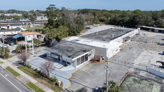
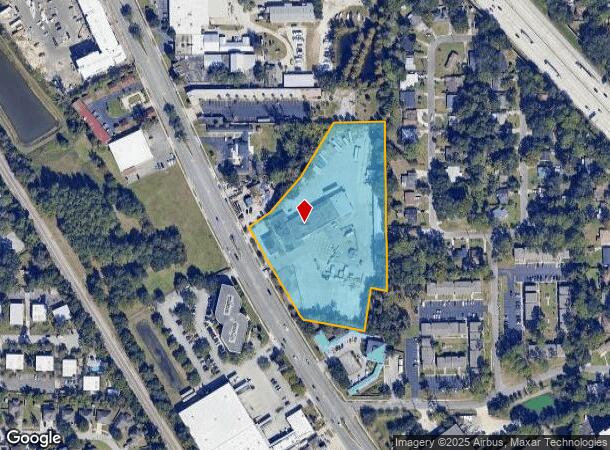
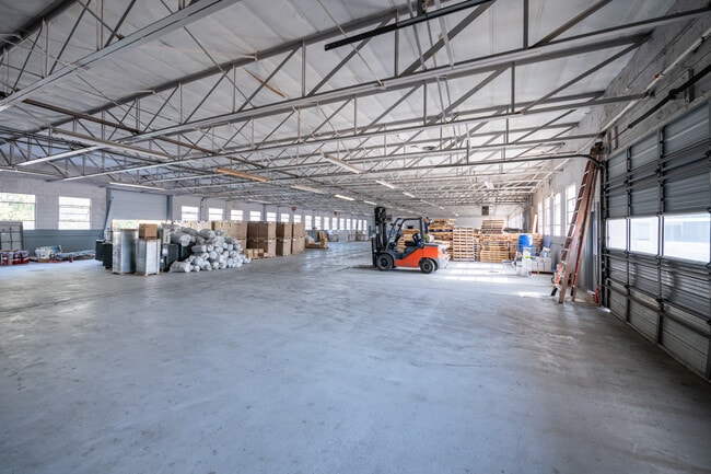
Property Record
3261 Philips Hwy, Jacksonville, FL 32207
Current Lease Availabilities
NEARBY LISTINGS FOR SALE OR LEASE
Property Detail
3261 Philips Hwy
Jacksonville, FL
Phillips S/D Pt Graig Gnt
130418-0000
AQ-478 44-2S-27E 4.95 PHILLIPS S/D PT CRAIG GRANT PT LOT 15, PT CRAIG GRANT RECD O/R 20410-961
Warehouse
Duval
AE
Florida
12031C0367J
15
2024
5.05 AC
2025
San Marco
000600
Jacksonville (Florida)
34,864 SF
DEMOGRAPHICS near 3261 Philips Hwy
1 Mile
3 Mile
5 Mile
2024 Total Population
12,017
70,504
221,137
2029 Population
13,451
79,092
247,602
Pop Growth 2024-2029
+ 11.93%
+ 12.18%
+ 11.97%
Average Age
39
41
39
2024 Total Households
4,982
30,471
93,514
HH Growth 2024-2029
+ 12.42%
+ 13.37%
+ 12.68%
Median Household Inc
$45,827
$49,497
$47,881
Avg Household Size
2.30
2.10
2.20
2024 Avg HH Vehicles
1.00
1.00
1.00
Median Home Value
$197,474
$260,693
$236,637
Median Year Built
1958
1967
1967
Nearby Places
Map Layers
Map Styles
 Street
 Aerial
- Restaurants
- Banks
- Shops
- Fitness
- Groceries
PUBLIC TRANSPORTATION
COMMUTER RAIL
DRIVE
WALK
Distance
17 min
9.4 mi
AIRPORT
Jacksonville International
DRIVE
WALK
Distance
Jacksonville International
29 min
18.0 mi
Freight Ports
Jacksonville Port
DRIVE
WALK
Distance
Jacksonville Port
15 min
7.8 mi
Nearby Properties
Address
Land Use
TOTAL SIZE
Lot Size
Zoning
Address
Land Use
TOTAL SIZE
Lot Size
Zoning
1,086,885 SF
16.83 AC
CCBD
Address
Land Use
TOTAL SIZE
Lot Size
Zoning
543,383 SF
7.87 AC
CCBD
Address
Land Use
TOTAL SIZE
Lot Size
Zoning
1,150,143 SF
43.90 AC
CCBD
Address
Land Use
TOTAL SIZE
Lot Size
Zoning
442,972 SF
5.33 AC
PUD
Address
Land Use
TOTAL SIZE
Lot Size
Zoning
875,866 SF
22.33 AC
PBF-3
Address
Land Use
TOTAL SIZE
Lot Size
Zoning
407,122 SF
4.50 AC
CCBD
Address
Land Use
TOTAL SIZE
Lot Size
Zoning
165,408 SF
2.45 AC
CCBD
Address
Land Use
TOTAL SIZE
Lot Size
Zoning
521,850 SF
10.06 AC
CCBD
Address
Land Use
TOTAL SIZE
Lot Size
Zoning
831,560 SF
1.16 AC
PUD
Address
Land Use
TOTAL SIZE
Lot Size
Zoning
187,278 SF
1.71 AC
CCBD
Address
Land Use
TOTAL SIZE
Lot Size
Zoning
127,732 SF
1.44 AC
CCBD
Address
Land Use
TOTAL SIZE
Lot Size
Zoning
146,636 SF
2.88 AC
CCBD
Address
Land Use
TOTAL SIZE
Lot Size
Zoning
264,277 SF
2.07 AC
CCBD
Address
Land Use
TOTAL SIZE
Lot Size
Zoning
369,638 SF
6.30 AC
CCBD
Address
Land Use
TOTAL SIZE
Lot Size
Zoning
326,485 SF
1.56 AC
CCBD
Address
Land Use
TOTAL SIZE
Lot Size
Zoning
992,501 SF
2.97 AC
CCBD
Address
Land Use
TOTAL SIZE
Lot Size
Zoning
503,858 SF
1.32 AC
CCBD
Address
Land Use
TOTAL SIZE
Lot Size
Zoning
194,877 SF
11.64 AC
CCBD
Address
Land Use
TOTAL SIZE
Lot Size
Zoning
336,623 SF
1.98 AC
CCBD
Address
Land Use
TOTAL SIZE
Lot Size
Zoning
453,728 SF
8.20 AC
CCBD
Address
Land Use
TOTAL SIZE
Lot Size
Zoning
290,975 SF
4.49 AC
PUD
Address
Land Use
TOTAL SIZE
Lot Size
Zoning
355,967 SF
8.98 AC
PUD
Address
Land Use
TOTAL SIZE
Lot Size
Zoning
224,600 SF
3.41 AC
PUD
Address
Land Use
TOTAL SIZE
Lot Size
Zoning
253,858 SF
4.93 AC
PUD
Address
Land Use
TOTAL SIZE
Lot Size
Zoning
212,152 SF
8.17 AC
CCBD
Address
Land Use
TOTAL SIZE
Lot Size
Zoning
270,000 SF
8.90 AC
PUD
Address
Land Use
TOTAL SIZE
Lot Size
Zoning
700,443 SF
8 AC
CCBD
Address
Land Use
TOTAL SIZE
Lot Size
Zoning
329,412 SF
1.75 AC
CCBD
Address
Land Use
TOTAL SIZE
Lot Size
Zoning
203,763 SF
9.97 AC
PUD
Address
Land Use
TOTAL SIZE
Lot Size
Zoning
211,073 SF
8.99 AC
PUD
The World's #1 Commercial Real Estate Marketplace
Connect with us
© 2025 CoStar Group
The information above has been obtained from sources believed reliable. While we do not doubt its accuracy we have not verified it and make no guarantee, warranty or representation about it. It is your responsibility to independently confirm its accuracy and completeness. Any projections, opinions, assumptions, or estimates used are for example only and do not represent the current or future performance of the property. The value of this transaction to you depends on tax and other factors which should be evaluated by your tax, financial, and legal advisors. You and your advisors should conduct a careful, independent investigation of the property to determine to your satisfaction the suitability of the property for your needs.