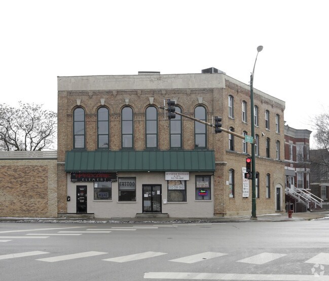
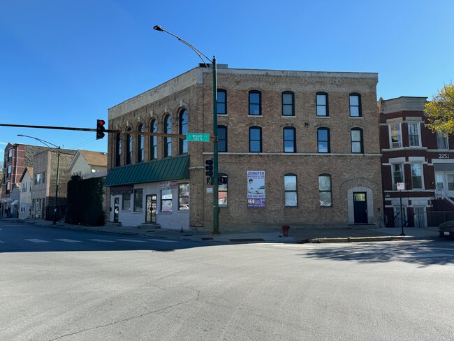
Property Record
1736 W 33Rd St, Chicago, IL 60608

NEARBY LISTINGS FOR SALE OR LEASE
Property Detail
1736 W 33Rd St
Chicago-Naperville-Elgin, IL-IN-WI
Canal Trustees Sub
17-31-212-037-0000
(SUBDIVISION) OF BLK9 IN CANAL TRUSTEES SUB OF EH SEC 31-39-14
Sfr
Cook
X
Illinois
17031C0508J
27,26
2023
0.09 AC
2025
McKinley Park
840400
Chicago
1,092 SF
DEMOGRAPHICS near 1736 W 33Rd St
1 Mile
3 Mile
5 Mile
2024 Total Population
20,997
288,041
876,598
2029 Population
19,469
267,906
835,446
Pop Growth 2024-2029
(7.28%)
(6.99%)
(4.69%)
Average Age
38
37
37
2024 Total Households
7,558
104,061
363,605
HH Growth 2024-2029
(7.70%)
(6.95%)
(4.21%)
Median Household Inc
$64,514
$49,994
$65,731
Avg Household Size
2.70
2.60
2.30
2024 Avg HH Vehicles
1.00
1.00
1.00
Median Home Value
$312,219
$281,457
$311,604
Median Year Built
1947
1949
1962
Nearby Places
Map Layers
Map Styles
 Street
 Aerial
- Restaurants
- Banks
- Shops
- Fitness
- Groceries
PUBLIC TRANSPORTATION
TRANSIT/SUBWAY
Ashland Station (Orange Line) (Orange Line - Chicago Transit Authority "L" Trains (The "L"))
DRIVE
WALK
Distance
Ashland Station (Orange Line) (Orange Line - Chicago Transit Authority "L" Trains (The "L"))
2 min
9 min
0.5 mi
35Th/Archer Station (Orange Line - Chicago Transit Authority "L" Trains (The "L"))
DRIVE
WALK
Distance
35Th/Archer Station (Orange Line - Chicago Transit Authority "L" Trains (The "L"))
3 min
14 min
0.7 mi
COMMUTER RAIL
35Th St. - Lou Jones (Rock Island - Metra)
DRIVE
WALK
Distance
35Th St. - Lou Jones (Rock Island - Metra)
5 min
2.4 mi
Western Avenue Station (Bnsf) (Burlington Northern-Santa Fe Railway Line - Northeast Illinois Regional Commuter Railroad (Metra))
DRIVE
WALK
Distance
Western Avenue Station (Bnsf) (Burlington Northern-Santa Fe Railway Line - Northeast Illinois Regional Commuter Railroad (Metra))
6 min
2.8 mi
AIRPORT
Chicago Midway International
DRIVE
WALK
Distance
Chicago Midway International
12 min
5.9 mi
Chicago O'Hare International
DRIVE
WALK
Distance
Chicago O'Hare International
33 min
20.4 mi
Freight Ports
Port Milwaukee
DRIVE
WALK
Distance
Port Milwaukee
111 min
88.6 mi
SALE & LEASE HISTORY
LISTING DATE
SALE/LEASE

Nov 22, 2024
For Sale
Apr 23, 2025
For Sale
Nearby Properties
Address
Land Use
TOTAL SIZE
Lot Size
Zoning
Address
Land Use
TOTAL SIZE
Lot Size
Zoning
1,215,367 SF
3.76 AC
PD 675
Address
Land Use
TOTAL SIZE
Lot Size
Zoning
590,844 SF
0.80 AC
PD 26
Address
Land Use
TOTAL SIZE
Lot Size
Zoning
1.44 AC
PD 30
Address
Land Use
TOTAL SIZE
Lot Size
Zoning
474,979 SF
29.67 AC
PD 553
Address
Land Use
TOTAL SIZE
Lot Size
Zoning
979,674 SF
6.01 AC
PD 924
Address
Land Use
TOTAL SIZE
Lot Size
Zoning
408,203 SF
2.02 AC
DS-5
Address
Land Use
TOTAL SIZE
Lot Size
Zoning
0.85 AC
DS-3
Address
Land Use
TOTAL SIZE
Lot Size
Zoning
3.17 AC
PD 96
Address
Land Use
TOTAL SIZE
Lot Size
Zoning
4.11 AC
M2-3
Address
Land Use
TOTAL SIZE
Lot Size
Zoning
460,333 SF
2.62 AC
C2-3
Address
Land Use
TOTAL SIZE
Lot Size
Zoning
136,720 SF
0.54 AC
PD 1
Address
Land Use
TOTAL SIZE
Lot Size
Zoning
134,800 SF
2.53 AC
PD 1273
Address
Land Use
TOTAL SIZE
Lot Size
Zoning
542,503 SF
7.78 AC
PD 523
Address
Land Use
TOTAL SIZE
Lot Size
Zoning
548,210 SF
1.11 AC
PD 681
Address
Land Use
TOTAL SIZE
Lot Size
Zoning
552,300 SF
0.69 AC
PMD 11
Address
Land Use
TOTAL SIZE
Lot Size
Zoning
111,322 SF
1 AC
DS-5
Address
Land Use
TOTAL SIZE
Lot Size
Zoning
4.85 AC
PD 1505
Address
Land Use
TOTAL SIZE
Lot Size
Zoning
Address
Land Use
TOTAL SIZE
Lot Size
Zoning
250,040 SF
15.70 AC
PD 1169
Address
Land Use
TOTAL SIZE
Lot Size
Zoning
27.31 AC
PD 1424
Address
Land Use
TOTAL SIZE
Lot Size
Zoning
333,340 SF
Address
Land Use
TOTAL SIZE
Lot Size
Zoning
121,250 SF
0.84 AC
PD 30
Address
Land Use
TOTAL SIZE
Lot Size
Zoning
225,784 SF
0.69 AC
DS-3
Address
Land Use
TOTAL SIZE
Lot Size
Zoning
169,435 SF
11.35 AC
PD 307
Address
Land Use
TOTAL SIZE
Lot Size
Zoning
103,442 SF
1.43 AC
DS-5
Address
Land Use
TOTAL SIZE
Lot Size
Zoning
313,559 SF
PD 1318
Address
Land Use
TOTAL SIZE
Lot Size
Zoning
433,317 SF
0.52 AC
PMD 11
Address
Land Use
TOTAL SIZE
Lot Size
Zoning
307,277 SF
9.90 AC
PMD 11
Address
Land Use
TOTAL SIZE
Lot Size
Zoning
64,012 SF
1.65 AC
PD 412
Address
Land Use
TOTAL SIZE
Lot Size
Zoning
10 AC
PD 1169
The World's #1 Commercial Real Estate Marketplace
Connect with us
© 2026 CoStar Group
The information above has been obtained from sources believed reliable. While we do not doubt its accuracy we have not verified it and make no guarantee, warranty or representation about it. It is your responsibility to independently confirm its accuracy and completeness. Any projections, opinions, assumptions, or estimates used are for example only and do not represent the current or future performance of the property. The value of this transaction to you depends on tax and other factors which should be evaluated by your tax, financial, and legal advisors. You and your advisors should conduct a careful, independent investigation of the property to determine to your satisfaction the suitability of the property for your needs.