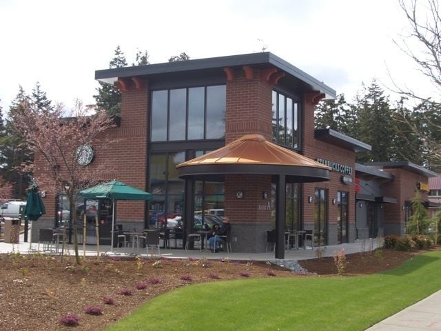
Property Record
32650 State Route 20, Oak Harbor, WA 98277
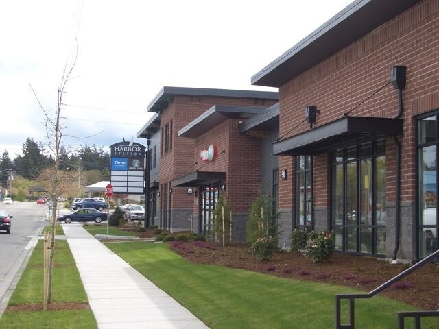

NEARBY LISTINGS FOR SALE OR LEASE
Property Detail
32650 State Route 20
Oak Harbor, WA
Koetje Replat L1
S7285-01-00007-0
KOETJE REPLAT L1 BLK C LOT 4 KT HARBOR STATION BSP.S7285-01-00004-0, -01-00010-0, -20-00063-0 & -00-0C002-1 BINDING SITE PLAN AF#4263087
Storebuilding
Island
X
Washington
53029C0120F
1,4
2025
1.18 AC
2025
Seattle North/Everett
970700
Other Market Areas
18,786 SF
DEMOGRAPHICS near 32650 State Route 20
1 Mile
3 Mile
5 Mile
2024 Total Population
10,643
28,952
37,032
2029 Population
10,528
28,696
36,774
Pop Growth 2024-2029
(1.08%)
(0.88%)
(0.70%)
Average Age
36
36
37
2024 Total Households
4,447
10,733
13,762
HH Growth 2024-2029
(1.12%)
(1.00%)
(0.81%)
Median Household Inc
$55,881
$65,265
$68,935
Avg Household Size
2.40
2.50
2.50
2024 Avg HH Vehicles
2.00
2.00
2.00
Median Home Value
$327,437
$372,543
$391,240
Median Year Built
1981
1984
1984
Nearby Places
Map Layers
Map Styles
 Street
 Aerial
- Restaurants
- Banks
- Shops
- Fitness
- Groceries
SALE & LEASE HISTORY
LISTING DATE
SALE/LEASE

Sep 25, 2016
For Lease
Nearby Properties
Address
Land Use
TOTAL SIZE
Lot Size
Zoning
Address
Land Use
TOTAL SIZE
Lot Size
Zoning
273,742 SF
44.92 AC
OH
Address
Land Use
TOTAL SIZE
Lot Size
Zoning
83,018 SF
3.07 AC
OH
Address
Land Use
TOTAL SIZE
Lot Size
Zoning
121,642 SF
6.28 AC
OH
Address
Land Use
TOTAL SIZE
Lot Size
Zoning
94,005 SF
4.79 AC
OH
Address
Land Use
TOTAL SIZE
Lot Size
Zoning
87,878 SF
15.76 AC
OH
Address
Land Use
TOTAL SIZE
Lot Size
Zoning
70,705 SF
7.47 AC
OH
Address
Land Use
TOTAL SIZE
Lot Size
Zoning
19,160 SF
8.50 AC
50
Address
Land Use
TOTAL SIZE
Lot Size
Zoning
105,488 SF
11.32 AC
C-5
Address
Land Use
TOTAL SIZE
Lot Size
Zoning
101,703 SF
10.66 AC
OH
Address
Land Use
TOTAL SIZE
Lot Size
Zoning
57,924 SF
19.54 AC
OH
Address
Land Use
TOTAL SIZE
Lot Size
Zoning
41,845 SF
3.29 AC
OH
Address
Land Use
TOTAL SIZE
Lot Size
Zoning
24,800 SF
3.18 AC
OH
Address
Land Use
TOTAL SIZE
Lot Size
Zoning
27,618 SF
3.91 AC
OH
Address
Land Use
TOTAL SIZE
Lot Size
Zoning
41,180 SF
12.68 AC
OH
Address
Land Use
TOTAL SIZE
Lot Size
Zoning
84,128 SF
8.36 AC
50
Address
Land Use
TOTAL SIZE
Lot Size
Zoning
30,649 SF
3.14 AC
OH
Address
Land Use
TOTAL SIZE
Lot Size
Zoning
43,347 SF
2.04 AC
Address
Land Use
TOTAL SIZE
Lot Size
Zoning
39,068 SF
2.15 AC
OH
Address
Land Use
TOTAL SIZE
Lot Size
Zoning
32,776 SF
3.30 AC
OH
Address
Land Use
TOTAL SIZE
Lot Size
Zoning
15,512 SF
3.15 AC
OH
Address
Land Use
TOTAL SIZE
Lot Size
Zoning
75,050 SF
6.75 AC
Address
Land Use
TOTAL SIZE
Lot Size
Zoning
53,090 SF
1.71 AC
OH
Address
Land Use
TOTAL SIZE
Lot Size
Zoning
44,368 SF
4.53 AC
OH
Address
Land Use
TOTAL SIZE
Lot Size
Zoning
13,999 SF
1.47 AC
OH
Address
Land Use
TOTAL SIZE
Lot Size
Zoning
41,632 SF
2.41 AC
OH
The World's #1 Commercial Real Estate Marketplace
Connect with us
© 2026 CoStar Group
The information above has been obtained from sources believed reliable. While we do not doubt its accuracy we have not verified it and make no guarantee, warranty or representation about it. It is your responsibility to independently confirm its accuracy and completeness. Any projections, opinions, assumptions, or estimates used are for example only and do not represent the current or future performance of the property. The value of this transaction to you depends on tax and other factors which should be evaluated by your tax, financial, and legal advisors. You and your advisors should conduct a careful, independent investigation of the property to determine to your satisfaction the suitability of the property for your needs.