Property Record
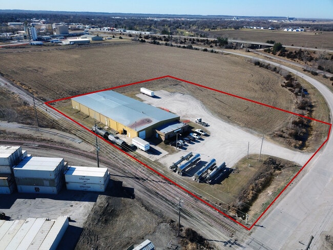
327 E County Road T, Fremont, NE 68025


Property Detail
327 E County Road T
270101752
TL 63 2.67A 11 17 8; MAP NUMBER: 2391-11-2-00000-000-0018
Industrialgeneral
DODGE
INDUSTRIAL
Nebraska
C and X Area of minimal flood hazard, usually depicted on FIRMs as above the 500-year flood level.
2.67 AC
2025
Nebraska Area
2025
Other Market Areas
964200
Fremont, NE
19,250 SF
NEARBY LISTINGS FOR SALE OR LEASE
-
-
View all Fremont listings for sale on LoopNet.com
DEMOGRAPHICS near 327 E County Road T
1 mile
3 mile
5 mile
2025 Total Population
1,949
26,669
30,686
2030 Population
2,081
27,157
31,398
Pop Growth 2025-2030
+ 6.77%
+ 1.83%
+ 2.32%
Average Age
44
40
40
2025 Total Households
862
10,676
12,206
HH Growth 2025-2030
+ 7.42%
+ 1.94%
+ 2.38%
Median Household Inc
$44,746
$70,333
$72,222
Avg Household Size
2.10
2.40
2.40
2025 Avg HH Vehicles
1.00
2.00
2.00
Median Home Value
$254,761
$218,711
$222,102
Median Year Built
1996
1965
1967
Nearby Places
Map Layers
Map Styles
 Street
 Aerial
Layers
 Traffic
 Biking
Places
Listings with unknown addresses are not visible on the map
- Restaurants
- Banks
- Shops
- Fitness
- Groceries
PUBLIC TRANSPORTATION
AIRPORT
Eppley Airfield
Drive
Walk
Distance
Eppley Airfield
62 min
40.5 mi
SALE & LEASE HISTORY
LISTING DATE
SALE/LEASE

Jan 23, 2024
For Sale
Nearby Properties
Address
Land Use
TOTAL SIZE
Lot Size
Zoning
Address
Land Use
TOTAL SIZE
Lot Size
Zoning
7,504 SF
25.27 AC
INDUSTRIAL
Address
Land Use
TOTAL SIZE
Lot Size
Zoning
33,392 SF
5.57 AC
SINGLE-FAM
Address
Land Use
TOTAL SIZE
Lot Size
Zoning
162,301 SF
18.06 AC
COMMERCIAL
Address
Land Use
TOTAL SIZE
Lot Size
Zoning
200,088 SF
23.04 AC
COMMERCIAL
Address
Land Use
TOTAL SIZE
Lot Size
Zoning
59,307 SF
1.99 AC
COMMERCIAL
Address
Land Use
TOTAL SIZE
Lot Size
Zoning
36,061 SF
8.89 AC
COMMERCIAL
Address
Land Use
TOTAL SIZE
Lot Size
Zoning
99,964 SF
7.47 AC
INDUSTRIAL
Address
Land Use
TOTAL SIZE
Lot Size
Zoning
65,589 SF
5.76 AC
COMMERCIAL
Address
Land Use
TOTAL SIZE
Lot Size
Zoning
60,000 SF
11.02 AC
INDUSTRIAL
Address
Land Use
TOTAL SIZE
Lot Size
Zoning
67,947 SF
10.67 AC
INDUSTRIAL
Address
Land Use
TOTAL SIZE
Lot Size
Zoning
4,952 SF
4.64 AC
MULTI-FAMI
Address
Land Use
TOTAL SIZE
Lot Size
Zoning
43,560 SF
1.75 AC
COMMERCIAL
Address
Land Use
TOTAL SIZE
Lot Size
Zoning
18,346 SF
2.94 AC
COMMERCIAL
Address
Land Use
TOTAL SIZE
Lot Size
Zoning
45,228 SF
2.01 AC
COMMERCIAL
Address
Land Use
TOTAL SIZE
Lot Size
Zoning
49,481 SF
4.86 AC
COMMERCIAL
Address
Land Use
TOTAL SIZE
Lot Size
Zoning
44,736 SF
2.45 AC
COMMERCIAL
Address
Land Use
TOTAL SIZE
Lot Size
Zoning
16,360 SF
1.67 AC
COMMERCIAL
Address
Land Use
TOTAL SIZE
Lot Size
Zoning
26,880 SF
5.11 AC
COMMERCIAL
Address
Land Use
TOTAL SIZE
Lot Size
Zoning
11,810 SF
13.42 AC
COMMERCIAL
Address
Land Use
TOTAL SIZE
Lot Size
Zoning
28,088 SF
10 AC
INDUSTRIAL
Address
Land Use
TOTAL SIZE
Lot Size
Zoning
69,051 SF
9.60 AC
COMMERCIAL
Address
Land Use
TOTAL SIZE
Lot Size
Zoning
59,225 SF
5.41 AC
COMMERCIAL
Address
Land Use
TOTAL SIZE
Lot Size
Zoning
52,830 SF
12.87 AC
INDUSTRIAL
Address
Land Use
TOTAL SIZE
Lot Size
Zoning
26,226 SF
2.06 AC
COMMERCIAL
Address
Land Use
TOTAL SIZE
Lot Size
Zoning
167,100 SF
8.92 AC
INDUSTRIAL
Address
Land Use
TOTAL SIZE
Lot Size
Zoning
40,699 SF
9.29 AC
INDUSTRIAL
Address
Land Use
TOTAL SIZE
Lot Size
Zoning
86,250 SF
8.09 AC
INDUSTRIAL
Address
Land Use
TOTAL SIZE
Lot Size
Zoning
19,208 SF
5.38 AC
COMMERCIAL
Address
Land Use
TOTAL SIZE
Lot Size
Zoning
14,956 SF
2.48 AC
COMMERCIAL
The World's #1 Commercial Real Estate Marketplace
Connect with us
© 2026 CoStar Group
The information above has been obtained from sources believed reliable. While we do not doubt its accuracy we have not verified it and make no guarantee, warranty or representation about it. It is your responsibility to independently confirm its accuracy and completeness. Any projections, opinions, assumptions, or estimates used are for example only and do not represent the current or future performance of the property. The value of this transaction to you depends on tax and other factors which should be evaluated by your tax, financial, and legal advisors. You and your advisors should conduct a careful, independent investigation of the property to determine to your satisfaction the suitability of the property for your needs.