Property Record
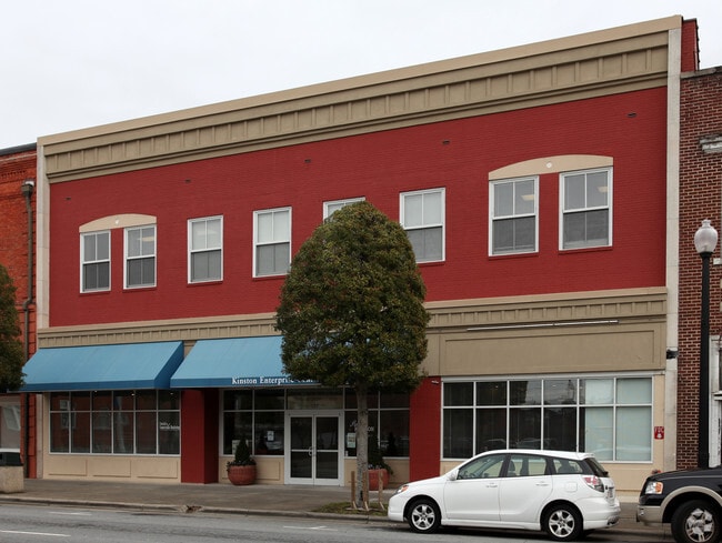
327 N Queen St, Kinston, NC 28501


Current Lease Availabilities
NEARBY LISTINGS FOR SALE OR LEASE
Property Detail
327 N Queen St
452555336860
KINSTON ENTERPRISE CNTR 327 N QUEEN ST
Commercialnec
Lenoir
X
North Carolina
3720452500K
0.33 AC
2025
North Carolina Southeast Area
2025
Other Market Areas
010700
Kinston, NC
23,581 SF
DEMOGRAPHICS near 327 N Queen St
1 Mile
3 Mile
5 Mile
2024 Total Population
7,267
20,163
27,875
2029 Population
7,494
20,202
27,779
Pop Growth 2024-2029
+ 3.12%
+ 0.19%
(0.34%)
Average Age
40
42
43
2024 Total Households
3,406
8,791
11,978
HH Growth 2024-2029
+ 3.02%
+ 0.24%
(0.33%)
Median Household Inc
$21,539
$32,128
$35,587
Avg Household Size
2.00
2.20
2.20
2024 Avg HH Vehicles
1.00
1.00
2.00
Median Home Value
$61,599
$96,157
$96,458
Median Year Built
1958
1967
1971
Nearby Places
Map Layers
Map Styles
 Street
 Aerial
- Restaurants
- Banks
- Shops
- Fitness
- Groceries
PUBLIC TRANSPORTATION
AIRPORT
Pitt-Greenville
DRIVE
WALK
Distance
Pitt-Greenville
44 min
30.3 mi
Albert J Ellis
DRIVE
WALK
Distance
Albert J Ellis
63 min
35.1 mi
Coastal Carolina Regional
DRIVE
WALK
Distance
Coastal Carolina Regional
51 min
38.7 mi
Freight Ports
Port of Morehead City
DRIVE
WALK
Distance
Port of Morehead City
111 min
76.5 mi
Nearby Properties
Address
Land Use
TOTAL SIZE
Lot Size
Zoning
Address
Land Use
TOTAL SIZE
Lot Size
Zoning
274,824 SF
54.92 AC
OI
Address
Land Use
TOTAL SIZE
Lot Size
Zoning
22,420 SF
762.37 AC
RA6
Address
Land Use
TOTAL SIZE
Lot Size
Zoning
114,876 SF
64.24 AC
RA6
Address
Land Use
TOTAL SIZE
Lot Size
Zoning
107,460 SF
17.70 AC
I2
Address
Land Use
TOTAL SIZE
Lot Size
Zoning
20,042 SF
77.79 AC
O&I
Address
Land Use
TOTAL SIZE
Lot Size
Zoning
191,518 SF
20.71 AC
SC
Address
Land Use
TOTAL SIZE
Lot Size
Zoning
144,099 SF
23.48 AC
RA8
Address
Land Use
TOTAL SIZE
Lot Size
Zoning
525,504 SF
76.02 AC
I1
Address
Land Use
TOTAL SIZE
Lot Size
Zoning
77,100 SF
1.91 AC
B2
Address
Land Use
TOTAL SIZE
Lot Size
Zoning
119,634 SF
1.86 AC
B2
Address
Land Use
TOTAL SIZE
Lot Size
Zoning
51,934 SF
0.32 AC
B2
Address
Land Use
TOTAL SIZE
Lot Size
Zoning
5,664 SF
407.13 AC
RA6
Address
Land Use
TOTAL SIZE
Lot Size
Zoning
53,768 SF
33.29 AC
I1
Address
Land Use
TOTAL SIZE
Lot Size
Zoning
73,800 SF
5.38 AC
B1
Address
Land Use
TOTAL SIZE
Lot Size
Zoning
18,213 SF
159.12 AC
OI
Address
Land Use
TOTAL SIZE
Lot Size
Zoning
23,086 SF
7.39 AC
RA5
Address
Land Use
TOTAL SIZE
Lot Size
Zoning
424,443 SF
104.04 AC
SC
Address
Land Use
TOTAL SIZE
Lot Size
Zoning
44,800 SF
9.75 AC
O&I
Address
Land Use
TOTAL SIZE
Lot Size
Zoning
6,178 SF
6.33 AC
RA5
Address
Land Use
TOTAL SIZE
Lot Size
Zoning
108,816 SF
1.30 AC
B2
Address
Land Use
TOTAL SIZE
Lot Size
Zoning
11,270 SF
112 AC
RA6
Address
Land Use
TOTAL SIZE
Lot Size
Zoning
64,506 SF
10.64 AC
I1
Address
Land Use
TOTAL SIZE
Lot Size
Zoning
8,640 SF
8.03 AC
RA5
Address
Land Use
TOTAL SIZE
Lot Size
Zoning
83,088 SF
1.19 AC
B2
Address
Land Use
TOTAL SIZE
Lot Size
Zoning
290,820 SF
25.95 AC
I1
Address
Land Use
TOTAL SIZE
Lot Size
Zoning
3,724 SF
8.84 AC
RA5
Address
Land Use
TOTAL SIZE
Lot Size
Zoning
51,828 SF
7.05 AC
O&I
Address
Land Use
TOTAL SIZE
Lot Size
Zoning
6,760 SF
147.39 AC
RA6
Address
Land Use
TOTAL SIZE
Lot Size
Zoning
43,545 SF
5.62 AC
SC
Address
Land Use
TOTAL SIZE
Lot Size
Zoning
7,140 SF
5.04 AC
The World's #1 Commercial Real Estate Marketplace
Connect with us
© 2025 CoStar Group
The information above has been obtained from sources believed reliable. While we do not doubt its accuracy we have not verified it and make no guarantee, warranty or representation about it. It is your responsibility to independently confirm its accuracy and completeness. Any projections, opinions, assumptions, or estimates used are for example only and do not represent the current or future performance of the property. The value of this transaction to you depends on tax and other factors which should be evaluated by your tax, financial, and legal advisors. You and your advisors should conduct a careful, independent investigation of the property to determine to your satisfaction the suitability of the property for your needs.