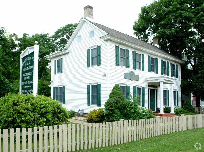
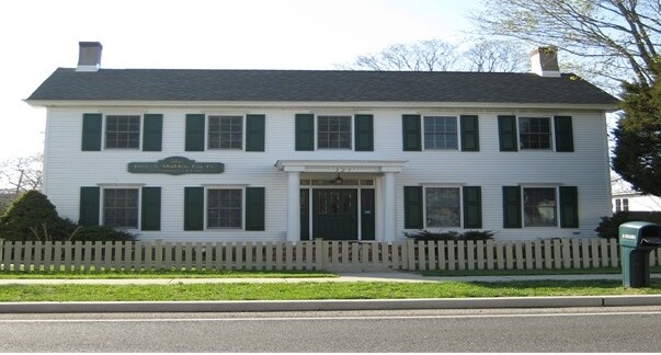
Property Record
327 S Main St, Barnegat, NJ 08005


Save to a Folder
{{folder.Name}}
{{folder.ListingIds.length}} Properties
{{folder.ListingIds.length}} Property
Create a New Folder
Property Detail
327 S Main St
01-00170-0000-00004
.29 AC HOME CARE
Commercialnec
Ocean
CVH
New Jersey
B and X Area of moderate flood hazard, usually the area between the limits of the 100-year and 500-year floods.
4
2025
0.29 AC
2026
Ocean County
734003
Northern New Jersey
2,226 SF
Lakewood-New Brunswick, NJ
NEARBY LISTINGS FOR SALE OR LEASE
-
-
View all Barnegat listings for sale on LoopNet.com
DEMOGRAPHICS near 327 S Main St
1 mile
3 mile
5 mile
2025 Total Population
3,412
30,198
57,371
2030 Population
3,491
31,013
59,072
Pop Growth 2025-2030
+ 2.32%
+ 2.70%
+ 2.96%
Average Age
37
44
43
2025 Total Households
1,187
11,588
22,049
HH Growth 2025-2030
+ 1.77%
+ 2.18%
+ 2.44%
Median Household Inc
$96,072
$98,904
$99,181
Avg Household Size
2.70
2.50
2.50
2025 Avg HH Vehicles
2.00
2.00
2.00
Median Home Value
$411,538
$414,019
$399,640
Median Year Built
1991
1993
1993
Nearby Places
Map Layers
Map Styles
 Street
 Aerial
Layers
 Traffic
 Biking
Places
Listings with unknown addresses are not visible on the map
- Restaurants
- Banks
- Shops
- Fitness
- Groceries
PUBLIC TRANSPORTATION
AIRPORT
Atlantic City International
Drive
Walk
Distance
Atlantic City International
65 min
35.0 mi
Nearby Properties
Address
Land Use
TOTAL SIZE
Lot Size
Zoning
Address
Land Use
TOTAL SIZE
Lot Size
Zoning
85.65 AC
R40
Address
Land Use
TOTAL SIZE
Lot Size
Zoning
46.40 AC
ML-4
Address
Land Use
TOTAL SIZE
Lot Size
Zoning
13.83 AC
CN
Address
Land Use
TOTAL SIZE
Lot Size
Zoning
6.36 AC
RGL/
Address
Land Use
TOTAL SIZE
Lot Size
Zoning
85.65 AC
R40
Address
Land Use
TOTAL SIZE
Lot Size
Zoning
7.49 AC
R20
Address
Land Use
TOTAL SIZE
Lot Size
Zoning
15.12 AC
R-2
Address
Land Use
TOTAL SIZE
Lot Size
Zoning
32,964 SF
4.01 AC
RB
Address
Land Use
TOTAL SIZE
Lot Size
Zoning
6,600 SF
10.67 AC
PRD
Address
Land Use
TOTAL SIZE
Lot Size
Zoning
67,548 SF
10.98 AC
CN
Address
Land Use
TOTAL SIZE
Lot Size
Zoning
11.91 AC
RA
Address
Land Use
TOTAL SIZE
Lot Size
Zoning
86,000 SF
2.87 AC
R20
Address
Land Use
TOTAL SIZE
Lot Size
Zoning
11.24 AC
R-2
Address
Land Use
TOTAL SIZE
Lot Size
Zoning
6.03 AC
MU
Address
Land Use
TOTAL SIZE
Lot Size
Zoning
23.70 AC
BCWD
Address
Land Use
TOTAL SIZE
Lot Size
Zoning
6.84 AC
MLP
Address
Land Use
TOTAL SIZE
Lot Size
Zoning
30.95 AC
ML-P
Address
Land Use
TOTAL SIZE
Lot Size
Zoning
89.90 AC
R-2
Address
Land Use
TOTAL SIZE
Lot Size
Zoning
56.23 AC
BC
Address
Land Use
TOTAL SIZE
Lot Size
Zoning
11,695 SF
9.31 AC
R20
Address
Land Use
TOTAL SIZE
Lot Size
Zoning
4,230 SF
10.65 AC
CPHD
Address
Land Use
TOTAL SIZE
Lot Size
Zoning
4.85 AC
CPHD
Address
Land Use
TOTAL SIZE
Lot Size
Zoning
14,490 SF
2.17 AC
NMC
Address
Land Use
TOTAL SIZE
Lot Size
Zoning
398 AC
PW
Address
Land Use
TOTAL SIZE
Lot Size
Zoning
3.34 AC
C-1
Address
Land Use
TOTAL SIZE
Lot Size
Zoning
5.14 AC
CPHD
Address
Land Use
TOTAL SIZE
Lot Size
Zoning
58,375 SF
5.46 AC
CPHD
Address
Land Use
TOTAL SIZE
Lot Size
Zoning
37,476 SF
14.66 AC
R6
Address
Land Use
TOTAL SIZE
Lot Size
Zoning
234 SF
10.71 AC
RGL/
Address
Land Use
TOTAL SIZE
Lot Size
Zoning
20.15 AC
MLP
The World's #1 Commercial Real Estate Marketplace
Connect with us
© 2026 CoStar Group
The information above has been obtained from sources believed reliable. While we do not doubt its accuracy we have not verified it and make no guarantee, warranty or representation about it. It is your responsibility to independently confirm its accuracy and completeness. Any projections, opinions, assumptions, or estimates used are for example only and do not represent the current or future performance of the property. The value of this transaction to you depends on tax and other factors which should be evaluated by your tax, financial, and legal advisors. You and your advisors should conduct a careful, independent investigation of the property to determine to your satisfaction the suitability of the property for your needs.