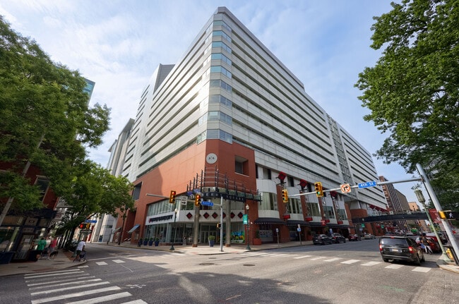
Property Record
327 Walnut St, Steelton, PA 17113


Current Lease Availabilities
NEARBY LISTINGS FOR SALE OR LEASE
Property Detail
327 Walnut St
Officecondo
Dauphin
X
Pennsylvania
42041C0119F
1.29 AC
2025
Harrisburg Area East
2025
Philadelphia
020100
Harrisburg-Carlisle, PA
570,800 SF
03-001-065
DEMOGRAPHICS near 327 Walnut St
1 Mile
3 Mile
5 Mile
2024 Total Population
19,470
107,684
206,001
2029 Population
20,255
112,093
214,331
Pop Growth 2024-2029
+ 4.03%
+ 4.09%
+ 4.04%
Average Age
37
38
40
2024 Total Households
9,251
45,252
85,085
HH Growth 2024-2029
+ 4.17%
+ 4.30%
+ 4.31%
Median Household Inc
$43,140
$57,053
$65,959
Avg Household Size
1.90
2.20
2.30
2024 Avg HH Vehicles
1.00
1.00
2.00
Median Home Value
$121,228
$159,459
$187,531
Median Year Built
1949
1952
1961
Nearby Places
Map Layers
Map Styles
 Street
 Aerial
- Restaurants
- Banks
- Shops
- Fitness
- Groceries
PUBLIC TRANSPORTATION
COMMUTER RAIL
Harrisburg (Keystone Service - Amtrak, Pennsylvanian - Amtrak)
DRIVE
WALK
Distance
Harrisburg (Keystone Service - Amtrak, Pennsylvanian - Amtrak)
7 min
3.3 mi
Middletown (Keystone Service - Amtrak)
DRIVE
WALK
Distance
Middletown (Keystone Service - Amtrak)
14 min
6.6 mi
AIRPORT
Harrisburg International
DRIVE
WALK
Distance
Harrisburg International
13 min
5.8 mi
Freight Ports
Port of Baltimore
DRIVE
WALK
Distance
Port of Baltimore
113 min
82.5 mi
Nearby Properties
Address
Land Use
TOTAL SIZE
Lot Size
Zoning
Address
Land Use
TOTAL SIZE
Lot Size
Zoning
474,282 SF
4.71 AC
Address
Land Use
TOTAL SIZE
Lot Size
Zoning
725,856 SF
2.15 AC
Address
Land Use
TOTAL SIZE
Lot Size
Zoning
372,234 SF
1.01 AC
Address
Land Use
TOTAL SIZE
Lot Size
Zoning
15,480 SF
17.80 AC
Address
Land Use
TOTAL SIZE
Lot Size
Zoning
365,162 SF
19.11 AC
Address
Land Use
TOTAL SIZE
Lot Size
Zoning
0.67 AC
Address
Land Use
TOTAL SIZE
Lot Size
Zoning
122,301 SF
32.30 AC
Address
Land Use
TOTAL SIZE
Lot Size
Zoning
349,587 SF
0.53 AC
Address
Land Use
TOTAL SIZE
Lot Size
Zoning
91,929 SF
45.10 AC
Address
Land Use
TOTAL SIZE
Lot Size
Zoning
284,737 SF
28.16 AC
Address
Land Use
TOTAL SIZE
Lot Size
Zoning
5,588 SF
9.29 AC
Address
Land Use
TOTAL SIZE
Lot Size
Zoning
218,468 SF
0.76 AC
Address
Land Use
TOTAL SIZE
Lot Size
Zoning
27,632 SF
59.50 AC
Address
Land Use
TOTAL SIZE
Lot Size
Zoning
10.55 AC
CH
Address
Land Use
TOTAL SIZE
Lot Size
Zoning
4.15 AC
Address
Land Use
TOTAL SIZE
Lot Size
Zoning
1,744 SF
21.79 AC
Address
Land Use
TOTAL SIZE
Lot Size
Zoning
2,068 SF
19.26 AC
Address
Land Use
TOTAL SIZE
Lot Size
Zoning
24,567 SF
15.33 AC
Address
Land Use
TOTAL SIZE
Lot Size
Zoning
116,216 SF
0.77 AC
Address
Land Use
TOTAL SIZE
Lot Size
Zoning
257,615 SF
0.80 AC
Address
Land Use
TOTAL SIZE
Lot Size
Zoning
109,912 SF
1.05 AC
Address
Land Use
TOTAL SIZE
Lot Size
Zoning
159,894 SF
0.27 AC
Address
Land Use
TOTAL SIZE
Lot Size
Zoning
81,176 SF
0.88 AC
Address
Land Use
TOTAL SIZE
Lot Size
Zoning
245,702 SF
0.38 AC
Address
Land Use
TOTAL SIZE
Lot Size
Zoning
167,713 SF
11.50 AC
Address
Land Use
TOTAL SIZE
Lot Size
Zoning
165,549 SF
65.10 AC
Address
Land Use
TOTAL SIZE
Lot Size
Zoning
261,792 SF
1.01 AC
Address
Land Use
TOTAL SIZE
Lot Size
Zoning
142,038 SF
9.39 AC
Address
Land Use
TOTAL SIZE
Lot Size
Zoning
1,254 SF
25.34 AC
The World's #1 Commercial Real Estate Marketplace
Connect with us
© 2025 CoStar Group
The information above has been obtained from sources believed reliable. While we do not doubt its accuracy we have not verified it and make no guarantee, warranty or representation about it. It is your responsibility to independently confirm its accuracy and completeness. Any projections, opinions, assumptions, or estimates used are for example only and do not represent the current or future performance of the property. The value of this transaction to you depends on tax and other factors which should be evaluated by your tax, financial, and legal advisors. You and your advisors should conduct a careful, independent investigation of the property to determine to your satisfaction the suitability of the property for your needs.