Property Record
3270 E 79Th St, Cleveland, OH 44104
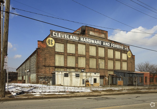

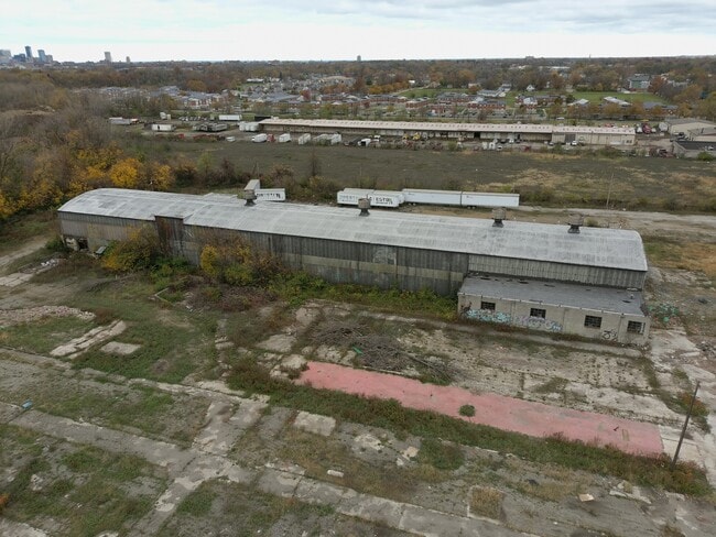
Property Detail
3270 E 79Th St
Cleveland-Elyria, OH
323 SEYMOUR L&H S/L 1 TO 14 ALL 15NP 53-54 & 55 ALL & NEXT W
125-23-018
Cuyahoga
Lightindustrial
Ohio
GI
323
B and X Area of moderate flood hazard, usually the area between the limits of the 100-year and 500-year floods.
11.03 AC
2025
Downtown Southeast
2025
Cleveland
114600
NEARBY LISTINGS FOR SALE OR LEASE
DEMOGRAPHICS near 3270 E 79Th St
1 mile
3 mile
5 mile
2025 Total Population
9,051
108,379
322,071
2030 Population
8,958
107,670
321,179
Pop Growth 2025-2030
(1.03%)
(0.65%)
(0.28%)
Average Age
36
39
39
2025 Total Households
3,860
48,765
144,585
HH Growth 2025-2030
(1.40%)
(0.67%)
(0.17%)
Median Household Inc
$29,334
$35,307
$43,973
Avg Household Size
2.20
2.10
2.10
2025 Avg HH Vehicles
1.00
1.00
1.00
Median Home Value
$73,990
$81,454
$123,261
Median Year Built
1947
1947
1948
Nearby Places
Map Layers
Map Styles
 Street
 Aerial
Layers
 Traffic
 Biking
Places
Listings with unknown addresses are not visible on the map
- Restaurants
- Banks
- Shops
- Fitness
- Groceries
PUBLIC TRANSPORTATION
TRANSIT/SUBWAY
East 79 (Blue Line) (Blue Line - Greater Cleveland Regional Transit Authority Rapid Transit (The Rapid), Green Line - Greater Cleveland Regional Transit Authority Rapid Transit (The Rapid))
Drive
Walk
Distance
East 79 (Blue Line) (Blue Line - Greater Cleveland Regional Transit Authority Rapid Transit (The Rapid), Green Line - Greater Cleveland Regional Transit Authority Rapid Transit (The Rapid))
1 min
15 min
0.7 mi
COMMUTER RAIL
Rockside (National Park Scenic Railway - Cuyahoga Valley Scenic Railroad)
Drive
Walk
Distance
Rockside (National Park Scenic Railway - Cuyahoga Valley Scenic Railroad)
15 min
6.1 mi
Cleveland Lakefront Station (Blue Line - Greater Cleveland Regional Transit Authority Rapid Transit (The Rapid), Green Line - Greater Cleveland Regional Transit Authority Rapid Transit (The Rapid))
Drive
Walk
Distance
Cleveland Lakefront Station (Blue Line - Greater Cleveland Regional Transit Authority Rapid Transit (The Rapid), Green Line - Greater Cleveland Regional Transit Authority Rapid Transit (The Rapid))
14 min
6.1 mi
AIRPORT
Cleveland-Hopkins International
Drive
Walk
Distance
Cleveland-Hopkins International
26 min
15.3 mi
Freight Ports
Port of Toledo
Drive
Walk
Distance
Port of Toledo
139 min
115.8 mi
SALE & LEASE HISTORY
LISTING DATE
SALE/LEASE

Oct 23, 2024
For Lease
Oct 23, 2024
For Sale
May 21, 2020
For Sale
Nearby Properties
Address
Land Use
TOTAL SIZE
Lot Size
Zoning
Address
Land Use
TOTAL SIZE
Lot Size
Zoning
3,172,147 SF
20.33 AC
GR
Address
Land Use
TOTAL SIZE
Lot Size
Zoning
1,211,519 SF
13.57 AC
GR
Address
Land Use
TOTAL SIZE
Lot Size
Zoning
2,064,168 SF
17.90 AC
GR
Address
Land Use
TOTAL SIZE
Lot Size
Zoning
1,104,152 SF
13.96 AC
GR
Address
Land Use
TOTAL SIZE
Lot Size
Zoning
942,168 SF
8.34 AC
IR
Address
Land Use
TOTAL SIZE
Lot Size
Zoning
53.85 AC
2F
Address
Land Use
TOTAL SIZE
Lot Size
Zoning
1,211,519 SF
13.63 AC
GR
Address
Land Use
TOTAL SIZE
Lot Size
Zoning
484,355 SF
11.60 AC
GR
Address
Land Use
TOTAL SIZE
Lot Size
Zoning
370,230 SF
4.08 AC
GR
Address
Land Use
TOTAL SIZE
Lot Size
Zoning
500,042 SF
1.34 AC
1F
Address
Land Use
TOTAL SIZE
Lot Size
Zoning
765,607 SF
12.15 AC
GR
Address
Land Use
TOTAL SIZE
Lot Size
Zoning
592,922 SF
11.72 AC
GR
Address
Land Use
TOTAL SIZE
Lot Size
Zoning
1,227,793 SF
6.80 AC
GR
Address
Land Use
TOTAL SIZE
Lot Size
Zoning
942,168 SF
9.93 AC
IR
Address
Land Use
TOTAL SIZE
Lot Size
Zoning
595,671 SF
14.98 AC
MF3+
Address
Land Use
TOTAL SIZE
Lot Size
Zoning
128,967 SF
3.54 AC
Address
Land Use
TOTAL SIZE
Lot Size
Zoning
913,527 SF
5.17 AC
GR
Address
Land Use
TOTAL SIZE
Lot Size
Zoning
230,820 SF
41.47 AC
UI
Address
Land Use
TOTAL SIZE
Lot Size
Zoning
243,720 SF
0.20 AC
GR
Address
Land Use
TOTAL SIZE
Lot Size
Zoning
374,227 SF
13.10 AC
MF3+
Address
Land Use
TOTAL SIZE
Lot Size
Zoning
724,884 SF
8.67 AC
Address
Land Use
TOTAL SIZE
Lot Size
Zoning
455,560 SF
1.23 AC
GR
Address
Land Use
TOTAL SIZE
Lot Size
Zoning
1,181,536 SF
27.82 AC
RO
Address
Land Use
TOTAL SIZE
Lot Size
Zoning
395,625 SF
0.74 AC
Address
Land Use
TOTAL SIZE
Lot Size
Zoning
767,400 SF
0.27 AC
GR
Address
Land Use
TOTAL SIZE
Lot Size
Zoning
143,000 SF
2.68 AC
MF3+
Address
Land Use
TOTAL SIZE
Lot Size
Zoning
794,077 SF
3.15 AC
IR
Address
Land Use
TOTAL SIZE
Lot Size
Zoning
282,498 SF
0.71 AC
GR
Address
Land Use
TOTAL SIZE
Lot Size
Zoning
130,535 SF
0.07 AC
SI
Address
Land Use
TOTAL SIZE
Lot Size
Zoning
373,544 SF
2.88 AC
GR
The World's #1 Commercial Real Estate Marketplace
Connect with us
© 2026 CoStar Group
The information above has been obtained from sources believed reliable. While we do not doubt its accuracy we have not verified it and make no guarantee, warranty or representation about it. It is your responsibility to independently confirm its accuracy and completeness. Any projections, opinions, assumptions, or estimates used are for example only and do not represent the current or future performance of the property. The value of this transaction to you depends on tax and other factors which should be evaluated by your tax, financial, and legal advisors. You and your advisors should conduct a careful, independent investigation of the property to determine to your satisfaction the suitability of the property for your needs.