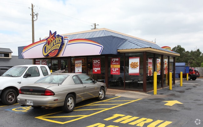
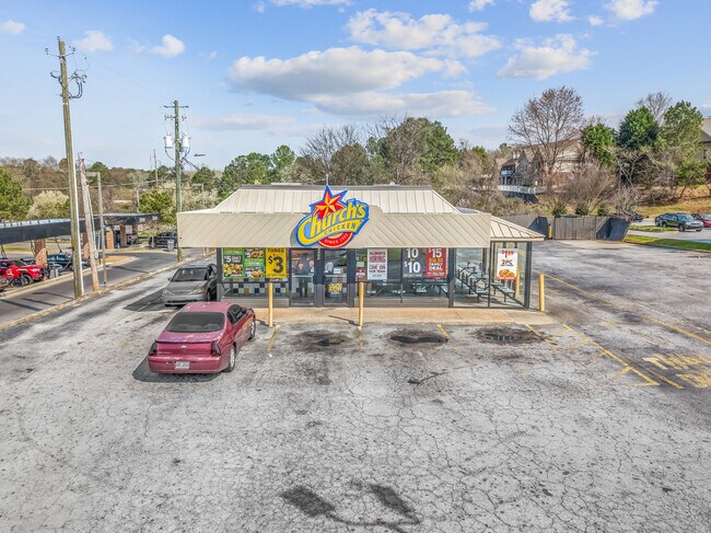
Property Record
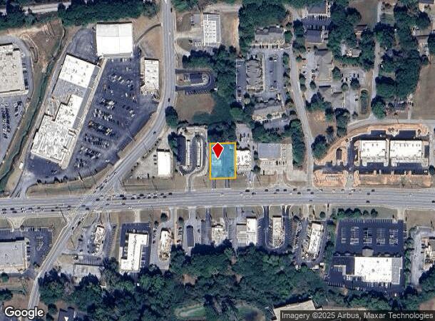
3275 Highway 278 Ne, Covington, GA 30014
NEARBY LISTINGS FOR SALE OR LEASE
Property Detail
3275 Highway 278 Ne
Atlanta-Sandy Springs-Roswell, GA
Hwy 278 Corridor
C022000020006000
.42AC - 3275 HWY 278 NE
Restaurantbuilding
Newton
X
Georgia
13217C0126D
255
2025
0.42 AC
2025
Lithonia/Conyers
100301
Atlanta
1,176 SF
DEMOGRAPHICS near 3275 Highway 278 Ne
1 Mile
3 Mile
5 Mile
2024 Total Population
4,343
26,694
49,925
2029 Population
4,848
29,779
55,605
Pop Growth 2024-2029
+ 11.63%
+ 11.56%
+ 11.38%
Average Age
40
38
38
2024 Total Households
1,758
10,025
18,021
HH Growth 2024-2029
+ 12.12%
+ 11.91%
+ 11.71%
Median Household Inc
$81,530
$71,810
$74,632
Avg Household Size
2.30
2.50
2.70
2024 Avg HH Vehicles
2.00
2.00
2.00
Median Home Value
$300,709
$185,544
$188,873
Median Year Built
1978
1990
1995
Nearby Places
Map Layers
Map Styles
 Street
 Aerial
- Restaurants
- Banks
- Shops
- Fitness
- Groceries
PUBLIC TRANSPORTATION
AIRPORT
Hartsfield - Jackson Atlanta International
DRIVE
WALK
Distance
Hartsfield - Jackson Atlanta International
51 min
38.5 mi
SALE & LEASE HISTORY
LISTING DATE
SALE/LEASE

Nov 19, 2020
For Sale
Mar 31, 2020
For Sale
Jan 04, 2019
For Sale
Apr 04, 2018
For Sale
Nearby Properties
Address
Land Use
TOTAL SIZE
Lot Size
Zoning
Address
Land Use
TOTAL SIZE
Lot Size
Zoning
8,358 SF
24.01 AC
Address
Land Use
TOTAL SIZE
Lot Size
Zoning
207,237 SF
10.61 AC
E1
Address
Land Use
TOTAL SIZE
Lot Size
Zoning
258,254 SF
15.08 AC
C1
Address
Land Use
TOTAL SIZE
Lot Size
Zoning
6,664 SF
17.75 AC
Address
Land Use
TOTAL SIZE
Lot Size
Zoning
214,590 SF
39.68 AC
Address
Land Use
TOTAL SIZE
Lot Size
Zoning
498,960 SF
97.46 AC
AR
Address
Land Use
TOTAL SIZE
Lot Size
Zoning
331,492 SF
163.71 AC
I1
Address
Land Use
TOTAL SIZE
Lot Size
Zoning
391,932 SF
73.70 AC
R1
Address
Land Use
TOTAL SIZE
Lot Size
Zoning
14,624 SF
26.09 AC
C1
Address
Land Use
TOTAL SIZE
Lot Size
Zoning
793,200 SF
63.82 AC
Address
Land Use
TOTAL SIZE
Lot Size
Zoning
7,130 SF
36.78 AC
A1
Address
Land Use
TOTAL SIZE
Lot Size
Zoning
544,058 SF
96.10 AC
I1
Address
Land Use
TOTAL SIZE
Lot Size
Zoning
676,458 SF
62.36 AC
Address
Land Use
TOTAL SIZE
Lot Size
Zoning
45,900 AC
Address
Land Use
TOTAL SIZE
Lot Size
Zoning
88,944 SF
0.98 AC
E1
Address
Land Use
TOTAL SIZE
Lot Size
Zoning
92,162 SF
11.21 AC
R2
Address
Land Use
TOTAL SIZE
Lot Size
Zoning
591,770 SF
37.73 AC
I1
Address
Land Use
TOTAL SIZE
Lot Size
Zoning
140,000 SF
21.91 AC
I1
Address
Land Use
TOTAL SIZE
Lot Size
Zoning
28,884 SF
38.23 AC
C1
Address
Land Use
TOTAL SIZE
Lot Size
Zoning
10,000 SF
0.01 AC
Address
Land Use
TOTAL SIZE
Lot Size
Zoning
262,782 SF
20.94 AC
Address
Land Use
TOTAL SIZE
Lot Size
Zoning
239,008 SF
54.79 AC
I1
Address
Land Use
TOTAL SIZE
Lot Size
Zoning
1,627 SF
16.62 AC
C1
Address
Land Use
TOTAL SIZE
Lot Size
Zoning
123,360 SF
109.16 AC
I1
Address
Land Use
TOTAL SIZE
Lot Size
Zoning
14,080 SF
10 AC
C1
Address
Land Use
TOTAL SIZE
Lot Size
Zoning
188,699 SF
12.04 AC
Address
Land Use
TOTAL SIZE
Lot Size
Zoning
150,000 SF
34.05 AC
Address
Land Use
TOTAL SIZE
Lot Size
Zoning
154,520 SF
7.98 AC
C1
Address
Land Use
TOTAL SIZE
Lot Size
Zoning
34,384 SF
3.32 AC
Address
Land Use
TOTAL SIZE
Lot Size
Zoning
112,884 SF
2.74 AC
The World's #1 Commercial Real Estate Marketplace
Connect with us
© 2025 CoStar Group
The information above has been obtained from sources believed reliable. While we do not doubt its accuracy we have not verified it and make no guarantee, warranty or representation about it. It is your responsibility to independently confirm its accuracy and completeness. Any projections, opinions, assumptions, or estimates used are for example only and do not represent the current or future performance of the property. The value of this transaction to you depends on tax and other factors which should be evaluated by your tax, financial, and legal advisors. You and your advisors should conduct a careful, independent investigation of the property to determine to your satisfaction the suitability of the property for your needs.