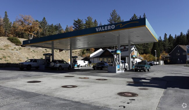
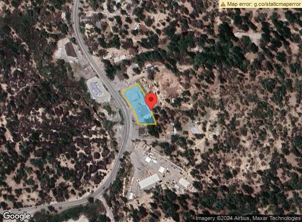
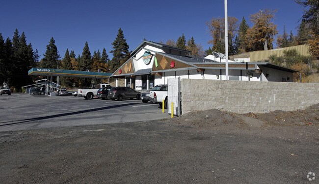
Property Record
32755 State Highway 18 Blvd, Running Springs, CA 92382

NEARBY LISTINGS FOR SALE OR LEASE
Property Detail
32755 State Highway 18 Blvd
Riverside-San Bernardino-Ontario, CA
Parcel Map No. 14769
0295-242-28
PARCEL MAP 14769 PARCEL 1 BOOK 178 PAGE 59
Servicestationmarket
San Bernardino
D
California
06071C8000H
1340
2024
0.70 AC
2025
Redlands/Loma Linda
011101
Inland Empire (California)
3,534 SF
DEMOGRAPHICS near 32755 State Highway 18 Blvd
1 Mile
3 Mile
5 Mile
2024 Total Population
1,287
5,042
5,339
2029 Population
1,265
4,968
5,261
Pop Growth 2024-2029
(1.71%)
(1.47%)
(1.46%)
Average Age
42
43
43
2024 Total Households
548
2,175
2,298
HH Growth 2024-2029
(1.82%)
(1.52%)
(1.48%)
Median Household Inc
$75,735
$79,178
$80,361
Avg Household Size
2.30
2.30
2.30
2024 Avg HH Vehicles
2.00
2.00
2.00
Median Home Value
$326,087
$360,197
$354,919
Median Year Built
1972
1971
1971
Nearby Places
Map Layers
Map Styles
 Street
 Aerial
- Restaurants
- Banks
- Shops
- Fitness
- Groceries
PUBLIC TRANSPORTATION
AIRPORT
Ontario International
DRIVE
WALK
Distance
Ontario International
66 min
44.0 mi
Nearby Properties
Address
Land Use
TOTAL SIZE
Lot Size
Zoning
Address
Land Use
TOTAL SIZE
Lot Size
Zoning
326,834 SF
38.56 AC
HTRC
Address
Land Use
TOTAL SIZE
Lot Size
Zoning
52,483 SF
25 AC
HTSDRES
Address
Land Use
TOTAL SIZE
Lot Size
Zoning
992 SF
80 AC
HTRC
Address
Land Use
TOTAL SIZE
Lot Size
Zoning
3,615 SF
21.73 AC
HTSDRES
Address
Land Use
TOTAL SIZE
Lot Size
Zoning
114.72 AC
HTRC
Address
Land Use
TOTAL SIZE
Lot Size
Zoning
2,894 SF
57.84 AC
HTRC
Address
Land Use
TOTAL SIZE
Lot Size
Zoning
9,328 SF
0.40 AC
HTCGSCP
Address
Land Use
TOTAL SIZE
Lot Size
Zoning
4,275 SF
0.36 AC
HTCGSCP
Address
Land Use
TOTAL SIZE
Lot Size
Zoning
19,256 SF
11.06 AC
HTRC
Address
Land Use
TOTAL SIZE
Lot Size
Zoning
4,664 SF
5.88 AC
HTCGSCP
Address
Land Use
TOTAL SIZE
Lot Size
Zoning
18,796 SF
11.88 AC
HTRC
Address
Land Use
TOTAL SIZE
Lot Size
Zoning
5,108 SF
0.21 AC
HTCGSCP
Address
Land Use
TOTAL SIZE
Lot Size
Zoning
7,144 SF
0.75 AC
HTCGSCP
Address
Land Use
TOTAL SIZE
Lot Size
Zoning
5,400 SF
0.59 AC
HTCGSCP
Address
Land Use
TOTAL SIZE
Lot Size
Zoning
126.07 AC
HTSDRES
Address
Land Use
TOTAL SIZE
Lot Size
Zoning
5,483 SF
9.17 AC
HTIC
Address
Land Use
TOTAL SIZE
Lot Size
Zoning
160.37 AC
HTRC
Address
Land Use
TOTAL SIZE
Lot Size
Zoning
4,307 SF
1.68 AC
HTCGSCP
Address
Land Use
TOTAL SIZE
Lot Size
Zoning
4,752 SF
0.33 AC
HTCO
Address
Land Use
TOTAL SIZE
Lot Size
Zoning
3,029 SF
0.93 AC
HTCGSCP
Address
Land Use
TOTAL SIZE
Lot Size
Zoning
40.25 AC
HTSDRES
Address
Land Use
TOTAL SIZE
Lot Size
Zoning
4,617 SF
0.34 AC
HTCGSCP
Address
Land Use
TOTAL SIZE
Lot Size
Zoning
4,340 SF
0.57 AC
HTCGSCP
Address
Land Use
TOTAL SIZE
Lot Size
Zoning
12,082 SF
0.83 AC
HTCGSCP
Address
Land Use
TOTAL SIZE
Lot Size
Zoning
7,585 SF
2.39 AC
HTCGSCP
Address
Land Use
TOTAL SIZE
Lot Size
Zoning
3,000 SF
1.07 AC
HTIC
Address
Land Use
TOTAL SIZE
Lot Size
Zoning
8.63 AC
HTRC
Address
Land Use
TOTAL SIZE
Lot Size
Zoning
67.98 AC
HTSDRES
Address
Land Use
TOTAL SIZE
Lot Size
Zoning
9,075 SF
0.27 AC
HTIC
The World's #1 Commercial Real Estate Marketplace
Connect with us
© 2026 CoStar Group
The information above has been obtained from sources believed reliable. While we do not doubt its accuracy we have not verified it and make no guarantee, warranty or representation about it. It is your responsibility to independently confirm its accuracy and completeness. Any projections, opinions, assumptions, or estimates used are for example only and do not represent the current or future performance of the property. The value of this transaction to you depends on tax and other factors which should be evaluated by your tax, financial, and legal advisors. You and your advisors should conduct a careful, independent investigation of the property to determine to your satisfaction the suitability of the property for your needs.