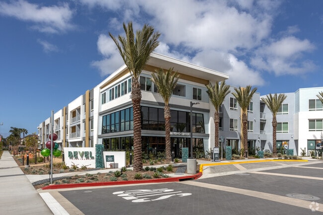
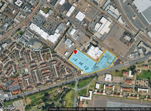
Property Record
3280 Barnett Ave, San Diego, CA 92110

NEARBY LISTINGS FOR SALE OR LEASE
Property Detail
3280 Barnett Ave
San Diego-Carlsbad, CA
Parcel Map No 21693
450-480-14
PAR 2 11.59 AC M/L IN TR PM21693
Multifamilydwelling
San Diego
X
California
06073C1877H
11.59 AC
2024
Midway District
2025
San Diego
006600
DEMOGRAPHICS near 3280 Barnett Ave
1 Mile
3 Mile
5 Mile
2024 Total Population
7,499
134,387
397,237
2029 Population
7,420
134,561
398,585
Pop Growth 2024-2029
(1.05%)
+ 0.13%
+ 0.34%
Average Age
37
41
40
2024 Total Households
2,864
62,621
184,942
HH Growth 2024-2029
(1.15%)
+ 0.17%
+ 0.41%
Median Household Inc
$86,337
$95,709
$88,980
Avg Household Size
2.40
1.90
2.00
2024 Avg HH Vehicles
2.00
2.00
2.00
Median Home Value
$1,016,195
$941,288
$901,754
Median Year Built
1976
1973
1975
Nearby Places
Map Layers
Map Styles
 Street
 Aerial
- Restaurants
- Banks
- Shops
- Fitness
- Groceries
PUBLIC TRANSPORTATION
COMMUTER RAIL
Old Town Transit Center (Coaster - San Diego North County Transit District (Coaster/Sprinter/Breeze))
DRIVE
WALK
Distance
Old Town Transit Center (Coaster - San Diego North County Transit District (Coaster/Sprinter/Breeze))
3 min
1.2 mi
San Diego (Santa Fe Depot) (Coaster - San Diego North County Transit District (Coaster/Sprinter/Breeze))
DRIVE
WALK
Distance
San Diego (Santa Fe Depot) (Coaster - San Diego North County Transit District (Coaster/Sprinter/Breeze))
6 min
3.2 mi
AIRPORT
San Diego International
DRIVE
WALK
Distance
San Diego International
5 min
1.6 mi
Freight Ports
Port of San Diego
DRIVE
WALK
Distance
Port of San Diego
11 min
6.4 mi
Nearby Properties
Address
Land Use
TOTAL SIZE
Lot Size
Zoning
Address
Land Use
TOTAL SIZE
Lot Size
Zoning
8.75 AC
60
Address
Land Use
TOTAL SIZE
Lot Size
Zoning
30,000 SF
62.51 AC
MVPD-MV-CR
Address
Land Use
TOTAL SIZE
Lot Size
Zoning
189.30 AC
M
Address
Land Use
TOTAL SIZE
Lot Size
Zoning
12.97 AC
RM-3-7
Address
Land Use
TOTAL SIZE
Lot Size
Zoning
42.78 AC
M
Address
Land Use
TOTAL SIZE
Lot Size
Zoning
496,552 SF
27.12 AC
M
Address
Land Use
TOTAL SIZE
Lot Size
Zoning
0.21 AC
CCPD-R
Address
Land Use
TOTAL SIZE
Lot Size
Zoning
1.38 AC
CCPD-CORE
Address
Land Use
TOTAL SIZE
Lot Size
Zoning
18.97 AC
C
Address
Land Use
TOTAL SIZE
Lot Size
Zoning
2.53 AC
EMX-1
Address
Land Use
TOTAL SIZE
Lot Size
Zoning
RM-4-10
Address
Land Use
TOTAL SIZE
Lot Size
Zoning
6.96 AC
MVPD-MVR-4
Address
Land Use
TOTAL SIZE
Lot Size
Zoning
15.37 AC
CC-3-8
Address
Land Use
TOTAL SIZE
Lot Size
Zoning
0.24 AC
CCPD-CORE
Address
Land Use
TOTAL SIZE
Lot Size
Zoning
2.50 AC
MVPD-MV-CO
Address
Land Use
TOTAL SIZE
Lot Size
Zoning
5.35 AC
MVPD-MV-CR
Address
Land Use
TOTAL SIZE
Lot Size
Zoning
0.83 AC
CCPD-CORE
Address
Land Use
TOTAL SIZE
Lot Size
Zoning
17.35 AC
C-6
Address
Land Use
TOTAL SIZE
Lot Size
Zoning
Address
Land Use
TOTAL SIZE
Lot Size
Zoning
18.33 AC
RS-1-7
Address
Land Use
TOTAL SIZE
Lot Size
Zoning
2.13 AC
C
Address
Land Use
TOTAL SIZE
Lot Size
Zoning
2.90 AC
MVPD-MV-CR
Address
Land Use
TOTAL SIZE
Lot Size
Zoning
1.19 AC
CCPD-CORE
Address
Land Use
TOTAL SIZE
Lot Size
Zoning
1.99 AC
EMX-1
Address
Land Use
TOTAL SIZE
Lot Size
Zoning
1.31 AC
CCPD-MC
Address
Land Use
TOTAL SIZE
Lot Size
Zoning
1.27 AC
CCDC-AWAIT
Address
Land Use
TOTAL SIZE
Lot Size
Zoning
1.81 AC
EMX-1
Address
Land Use
TOTAL SIZE
Lot Size
Zoning
283,689 SF
18.02 AC
M
Address
Land Use
TOTAL SIZE
Lot Size
Zoning
16.91 AC
EMX-1
The World's #1 Commercial Real Estate Marketplace
Connect with us
© 2026 CoStar Group
The information above has been obtained from sources believed reliable. While we do not doubt its accuracy we have not verified it and make no guarantee, warranty or representation about it. It is your responsibility to independently confirm its accuracy and completeness. Any projections, opinions, assumptions, or estimates used are for example only and do not represent the current or future performance of the property. The value of this transaction to you depends on tax and other factors which should be evaluated by your tax, financial, and legal advisors. You and your advisors should conduct a careful, independent investigation of the property to determine to your satisfaction the suitability of the property for your needs.