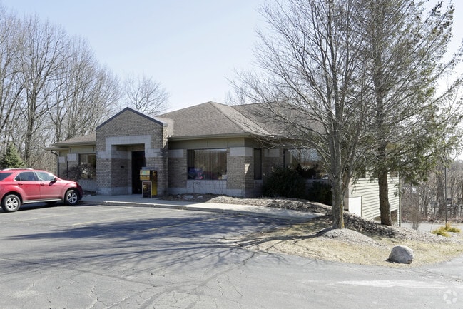
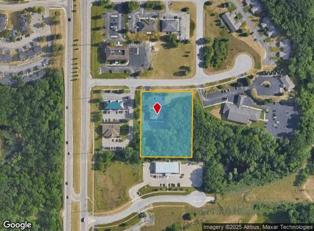
Property Record
3280 E Beltline Ct Ne, Grand Rapids, MI 49525

NEARBY LISTINGS FOR SALE OR LEASE
Property Detail
3280 E Beltline Ct Ne
Grand Rapids-Wyoming, MI
Summit Park Condominiums Kent County Con
41-10-35-125-020
UNIT 10 * SUMMIT PARK CONDOMINIUMS KENT COUNTY CONDOMINIUM SUBDIVISION PLAN NO.380 LIBER 4063 PAGE 115 AS AMENDED BY LIBER
Commercialnec
Kent
X
Michigan
26081C0312D
2.38 AC
2024
Northeast Grand Rapids
2025
West Michigan
011302
DEMOGRAPHICS near 3280 E Beltline Ct Ne
1 Mile
3 Mile
5 Mile
2024 Total Population
6,958
34,837
96,621
2029 Population
7,079
35,302
97,473
Pop Growth 2024-2029
+ 1.74%
+ 1.33%
+ 0.88%
Average Age
41
41
40
2024 Total Households
2,969
13,832
38,556
HH Growth 2024-2029
+ 1.68%
+ 1.27%
+ 0.84%
Median Household Inc
$76,450
$85,762
$74,676
Avg Household Size
2.30
2.50
2.40
2024 Avg HH Vehicles
2.00
2.00
2.00
Median Home Value
$318,409
$285,725
$257,964
Median Year Built
1987
1984
1977
Nearby Places
Map Layers
Map Styles
 Street
 Aerial
- Restaurants
- Banks
- Shops
- Fitness
- Groceries
PUBLIC TRANSPORTATION
AIRPORT
Gerald R Ford International
DRIVE
WALK
Distance
Gerald R Ford International
25 min
15.6 mi
SALE & LEASE HISTORY
LISTING DATE
SALE/LEASE

May 04, 2017
For Lease
Jan 18, 2021
For Sale
Nearby Properties
Address
Land Use
TOTAL SIZE
Lot Size
Zoning
Address
Land Use
TOTAL SIZE
Lot Size
Zoning
494,398 SF
R-PUD
Address
Land Use
TOTAL SIZE
Lot Size
Zoning
25.41 AC
Address
Land Use
TOTAL SIZE
Lot Size
Zoning
257,381 SF
7.08 AC
SD-PRD
Address
Land Use
TOTAL SIZE
Lot Size
Zoning
112,764 SF
17.29 AC
SD-PRD
Address
Land Use
TOTAL SIZE
Lot Size
Zoning
21.77 AC
MCN-MDR
Address
Land Use
TOTAL SIZE
Lot Size
Zoning
47,370 SF
8.18 AC
MON-LDR
Address
Land Use
TOTAL SIZE
Lot Size
Zoning
Address
Land Use
TOTAL SIZE
Lot Size
Zoning
Address
Land Use
TOTAL SIZE
Lot Size
Zoning
247,954 SF
40.84 AC
SD-PRD
Address
Land Use
TOTAL SIZE
Lot Size
Zoning
145,127 SF
18.52 AC
SD-PRD
Address
Land Use
TOTAL SIZE
Lot Size
Zoning
16.34 AC
Address
Land Use
TOTAL SIZE
Lot Size
Zoning
Address
Land Use
TOTAL SIZE
Lot Size
Zoning
13.26 AC
MON-MDR
Address
Land Use
TOTAL SIZE
Lot Size
Zoning
138,864 SF
34.91 AC
R-1
Address
Land Use
TOTAL SIZE
Lot Size
Zoning
14.36 AC
MON-MDR
Address
Land Use
TOTAL SIZE
Lot Size
Zoning
8.43 AC
Address
Land Use
TOTAL SIZE
Lot Size
Zoning
70,130 SF
2.99 AC
SD-PRD
Address
Land Use
TOTAL SIZE
Lot Size
Zoning
Address
Land Use
TOTAL SIZE
Lot Size
Zoning
Address
Land Use
TOTAL SIZE
Lot Size
Zoning
8 AC
MON-MDR
Address
Land Use
TOTAL SIZE
Lot Size
Zoning
8.68 AC
MON-MDR
Address
Land Use
TOTAL SIZE
Lot Size
Zoning
Address
Land Use
TOTAL SIZE
Lot Size
Zoning
74,409 SF
5.50 AC
SD-PRD
Address
Land Use
TOTAL SIZE
Lot Size
Zoning
Address
Land Use
TOTAL SIZE
Lot Size
Zoning
54,430 SF
2.26 AC
SD-PRD
Address
Land Use
TOTAL SIZE
Lot Size
Zoning
57.38 AC
MCN-C
Address
Land Use
TOTAL SIZE
Lot Size
Zoning
Address
Land Use
TOTAL SIZE
Lot Size
Zoning
Address
Land Use
TOTAL SIZE
Lot Size
Zoning
42,443 SF
5.29 AC
O-PUD
Address
Land Use
TOTAL SIZE
Lot Size
Zoning
The World's #1 Commercial Real Estate Marketplace
Connect with us
© 2025 CoStar Group
The information above has been obtained from sources believed reliable. While we do not doubt its accuracy we have not verified it and make no guarantee, warranty or representation about it. It is your responsibility to independently confirm its accuracy and completeness. Any projections, opinions, assumptions, or estimates used are for example only and do not represent the current or future performance of the property. The value of this transaction to you depends on tax and other factors which should be evaluated by your tax, financial, and legal advisors. You and your advisors should conduct a careful, independent investigation of the property to determine to your satisfaction the suitability of the property for your needs.