Property Record
3280 E Main St, Waterbury, CT 06705
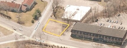

Property Detail
3280 E Main St
WATE-000379-000137-000021
NEW HAVEN
Vacantlandnec
Connecticut
CA
21
B and X Area of moderate flood hazard, usually the area between the limits of the 100-year and 500-year floods.
0.24 AC
2024
Waterbury
2025
Westchester/So Connecticut
352701
New Haven, CT
NEARBY LISTINGS FOR SALE OR LEASE
DEMOGRAPHICS near 3280 E Main St
1 mile
3 mile
5 mile
2025 Total Population
10,945
63,524
157,574
2030 Population
11,169
64,870
161,250
Pop Growth 2025-2030
+ 2.05%
+ 2.12%
+ 2.33%
Average Age
40
39
40
2025 Total Households
4,424
24,694
61,034
HH Growth 2025-2030
+ 2.06%
+ 2.11%
+ 2.38%
Median Household Inc
$61,865
$60,408
$65,008
Avg Household Size
2.40
2.50
2.50
2025 Avg HH Vehicles
2.00
2.00
2.00
Median Home Value
$194,435
$257,142
$271,506
Median Year Built
1967
1959
1962
Nearby Places
Map Layers
Map Styles
 Street
 Aerial
Transit
 Traffic
 Biking
Places
Listings with unknown addresses are not visible on the map
- Restaurants
- Banks
- Shops
- Fitness
- Groceries
PUBLIC TRANSPORTATION
COMMUTER RAIL
Waterbury Station (New Haven Line - Metro-North Commuter Railroad Company (Metro-North))
Drive
Walk
Distance
Waterbury Station (New Haven Line - Metro-North Commuter Railroad Company (Metro-North))
9 min
4.1 mi
Naugatuck Station (New Haven Line - Metro-North Commuter Railroad Company (Metro-North))
Drive
Walk
Distance
Naugatuck Station (New Haven Line - Metro-North Commuter Railroad Company (Metro-North))
13 min
7.0 mi
AIRPORT
Tweed/New Haven
Drive
Walk
Distance
Tweed/New Haven
40 min
24.1 mi
Bradley International
Drive
Walk
Distance
Bradley International
58 min
40.6 mi
Freight Ports
Port of New Haven
Drive
Walk
Distance
Port of New Haven
35 min
21.5 mi
Nearby Properties
Address
Land Use
TOTAL SIZE
Lot Size
Zoning
Address
Land Use
TOTAL SIZE
Lot Size
Zoning
77.50 AC
RS
Address
Land Use
TOTAL SIZE
Lot Size
Zoning
88,350 SF
9.50 AC
RS
Address
Land Use
TOTAL SIZE
Lot Size
Zoning
118,884 SF
13.40 AC
RL
Address
Land Use
TOTAL SIZE
Lot Size
Zoning
97,386 SF
53.20 AC
RS
Address
Land Use
TOTAL SIZE
Lot Size
Zoning
44.31 AC
CA
Address
Land Use
TOTAL SIZE
Lot Size
Zoning
95,000 SF
9.30 AC
RM
Address
Land Use
TOTAL SIZE
Lot Size
Zoning
5.13 AC
RM
Address
Land Use
TOTAL SIZE
Lot Size
Zoning
19.24 AC
CA
Address
Land Use
TOTAL SIZE
Lot Size
Zoning
12.49 AC
CA
Address
Land Use
TOTAL SIZE
Lot Size
Zoning
31.75 AC
CA
Address
Land Use
TOTAL SIZE
Lot Size
Zoning
18.01 AC
CA
Address
Land Use
TOTAL SIZE
Lot Size
Zoning
10.51 AC
RL
Address
Land Use
TOTAL SIZE
Lot Size
Zoning
91,324 SF
22.27 AC
RM
Address
Land Use
TOTAL SIZE
Lot Size
Zoning
25,474 SF
20.35 AC
RM
Address
Land Use
TOTAL SIZE
Lot Size
Zoning
25,844 SF
22.20 AC
R-80
Address
Land Use
TOTAL SIZE
Lot Size
Zoning
15.39 AC
RM
Address
Land Use
TOTAL SIZE
Lot Size
Zoning
1.30 AC
CBD
Address
Land Use
TOTAL SIZE
Lot Size
Zoning
152,704 SF
17.09 AC
CA
Address
Land Use
TOTAL SIZE
Lot Size
Zoning
1.02 AC
CBD
Address
Land Use
TOTAL SIZE
Lot Size
Zoning
81,501 SF
19 AC
R-30
Address
Land Use
TOTAL SIZE
Lot Size
Zoning
5.10 AC
RM
Address
Land Use
TOTAL SIZE
Lot Size
Zoning
95,030 SF
14.30 AC
RA-1
Address
Land Use
TOTAL SIZE
Lot Size
Zoning
115,996 SF
19.57 AC
CA
Address
Land Use
TOTAL SIZE
Lot Size
Zoning
35,200 SF
8.55 AC
B
Address
Land Use
TOTAL SIZE
Lot Size
Zoning
154,629 SF
18.76 AC
CA
Address
Land Use
TOTAL SIZE
Lot Size
Zoning
4,368 SF
13.97 AC
RM
Address
Land Use
TOTAL SIZE
Lot Size
Zoning
59,531 SF
2.70 AC
CA
Address
Land Use
TOTAL SIZE
Lot Size
Zoning
6.39 AC
RM
Address
Land Use
TOTAL SIZE
Lot Size
Zoning
61,173 SF
3.60 AC
RL
Address
Land Use
TOTAL SIZE
Lot Size
Zoning
90,198 SF
21.32 AC
CA
The World's #1 Commercial Real Estate Marketplace
Connect with us
© 2026 CoStar Group
The information above has been obtained from sources believed reliable. While we do not doubt its accuracy we have not verified it and make no guarantee, warranty or representation about it. It is your responsibility to independently confirm its accuracy and completeness. Any projections, opinions, assumptions, or estimates used are for example only and do not represent the current or future performance of the property. The value of this transaction to you depends on tax and other factors which should be evaluated by your tax, financial, and legal advisors. You and your advisors should conduct a careful, independent investigation of the property to determine to your satisfaction the suitability of the property for your needs.