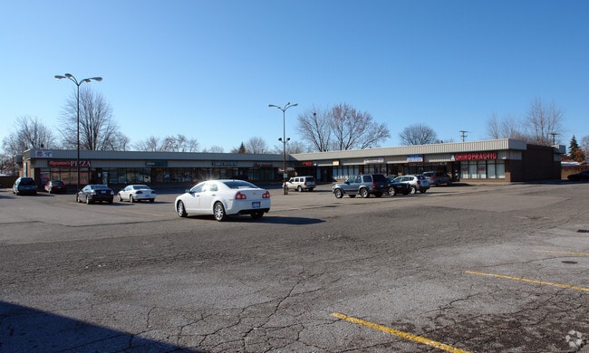
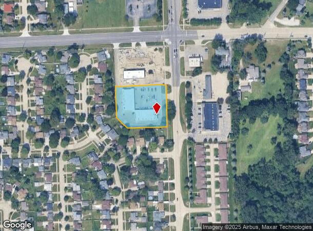
Property Record
32801 Hayes Rd, Warren, MI 48088

NEARBY LISTINGS FOR SALE OR LEASE
Property Detail
32801 Hayes Rd
12-13-01-228-023
SEC 1 COM AT NE COR SEC 1; TH N87*38'30"W 60.0 FT ALG N SEC LINE; TH S02*51'30"W 270.50 FTALG W LINE OF HAYES RD TO POB;TH
Commercialnec
Macomb
X
Michigan
26099C0336G
1.56 AC
2024
Macomb West
2025
Detroit
260000
Detroit-Warren-Dearborn, MI
6,360 SF
DEMOGRAPHICS near 32801 Hayes Rd
1 Mile
3 Mile
5 Mile
2024 Total Population
13,690
115,550
306,283
2029 Population
13,423
114,215
302,640
Pop Growth 2024-2029
(1.95%)
(1.16%)
(1.19%)
Average Age
44
43
42
2024 Total Households
5,346
48,131
126,933
HH Growth 2024-2029
(2.06%)
(1.17%)
(1.20%)
Median Household Inc
$81,017
$63,114
$63,571
Avg Household Size
2.50
2.30
2.40
2024 Avg HH Vehicles
2.00
2.00
2.00
Median Home Value
$197,498
$171,735
$168,171
Median Year Built
1968
1968
1967
Nearby Places
Map Layers
Map Styles
 Street
 Aerial
- Restaurants
- Banks
- Shops
- Fitness
- Groceries
PUBLIC TRANSPORTATION
AIRPORT
Windsor International
DRIVE
WALK
Distance
Windsor International
53 min
31.7 mi
Detroit Metro Wayne County
DRIVE
WALK
Distance
Detroit Metro Wayne County
58 min
41.3 mi
Freight Ports
Port of Toledo
DRIVE
WALK
Distance
Port of Toledo
103 min
82.2 mi
SALE & LEASE HISTORY
LISTING DATE
SALE/LEASE

Feb 10, 2017
For Lease
Nearby Properties
Address
Land Use
TOTAL SIZE
Lot Size
Zoning
Address
Land Use
TOTAL SIZE
Lot Size
Zoning
436,218 SF
36.43 AC
B-2
Address
Land Use
TOTAL SIZE
Lot Size
Zoning
303,770 SF
23.62 AC
R-3
Address
Land Use
TOTAL SIZE
Lot Size
Zoning
98,265 SF
7.04 AC
RM-2
Address
Land Use
TOTAL SIZE
Lot Size
Zoning
283,685 SF
19.90 AC
R-3
Address
Land Use
TOTAL SIZE
Lot Size
Zoning
148,330 SF
37.86 AC
RM-2
Address
Land Use
TOTAL SIZE
Lot Size
Zoning
24.38 AC
RML
Address
Land Use
TOTAL SIZE
Lot Size
Zoning
82,475 SF
16.81 AC
RM-2
Address
Land Use
TOTAL SIZE
Lot Size
Zoning
139,846 SF
16 AC
RM-2
Address
Land Use
TOTAL SIZE
Lot Size
Zoning
249,162 SF
27.87 AC
IC
Address
Land Use
TOTAL SIZE
Lot Size
Zoning
31.84 AC
RH
Address
Land Use
TOTAL SIZE
Lot Size
Zoning
16.11 AC
RM-2
Address
Land Use
TOTAL SIZE
Lot Size
Zoning
209,501 SF
17.74 AC
B-3
Address
Land Use
TOTAL SIZE
Lot Size
Zoning
91,104 SF
11.99 AC
RM-2
Address
Land Use
TOTAL SIZE
Lot Size
Zoning
247,177 SF
26.94 AC
CG
Address
Land Use
TOTAL SIZE
Lot Size
Zoning
217,369 SF
20.15 AC
B-2
Address
Land Use
TOTAL SIZE
Lot Size
Zoning
14.67 AC
RM-2
Address
Land Use
TOTAL SIZE
Lot Size
Zoning
204,620 SF
13.73 AC
R-3
Address
Land Use
TOTAL SIZE
Lot Size
Zoning
218,819 SF
15 AC
R-3
Address
Land Use
TOTAL SIZE
Lot Size
Zoning
102,598 SF
Address
Land Use
TOTAL SIZE
Lot Size
Zoning
376,278 SF
19.85 AC
RM-1
Address
Land Use
TOTAL SIZE
Lot Size
Zoning
7.18 AC
RMH
Address
Land Use
TOTAL SIZE
Lot Size
Zoning
370,077 SF
18.24 AC
B-2
Address
Land Use
TOTAL SIZE
Lot Size
Zoning
181,076 SF
8.16 AC
R-3
Address
Land Use
TOTAL SIZE
Lot Size
Zoning
10.37 AC
RML
Address
Land Use
TOTAL SIZE
Lot Size
Zoning
117,664 SF
6.66 AC
I-1
Address
Land Use
TOTAL SIZE
Lot Size
Zoning
157,610 SF
5.30 AC
RMH
Address
Land Use
TOTAL SIZE
Lot Size
Zoning
109,494 SF
7.54 AC
O
Address
Land Use
TOTAL SIZE
Lot Size
Zoning
108,366 SF
16.66 AC
O-2
Address
Land Use
TOTAL SIZE
Lot Size
Zoning
256 SF
5.57 AC
SP-1
Address
Land Use
TOTAL SIZE
Lot Size
Zoning
10.89 AC
RML
The World's #1 Commercial Real Estate Marketplace
Connect with us
© 2025 CoStar Group
The information above has been obtained from sources believed reliable. While we do not doubt its accuracy we have not verified it and make no guarantee, warranty or representation about it. It is your responsibility to independently confirm its accuracy and completeness. Any projections, opinions, assumptions, or estimates used are for example only and do not represent the current or future performance of the property. The value of this transaction to you depends on tax and other factors which should be evaluated by your tax, financial, and legal advisors. You and your advisors should conduct a careful, independent investigation of the property to determine to your satisfaction the suitability of the property for your needs.