Property Record
3281 Peoples Dr, Harrisonburg, VA 22801


NEARBY LISTINGS FOR SALE OR LEASE
-
-
View all Harrisonburg listings for sale on LoopNet.com
Property Detail
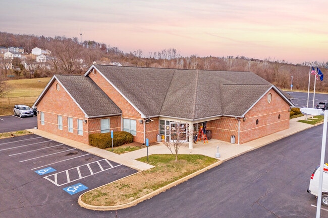
3281 Peoples Dr
104-F-2
Parkland
Officebuilding
COMMERCIAL DISTRICT 5 NS PEOPLES DR
X
Harrisonburg
51165C0391D
Virginia
2024
2.22 AC
2025
Staunton & Harrisonburg
000302
Other Market Areas
9,331 SF
Harrisonburg, VA
DEMOGRAPHICS near 3281 Peoples Dr
1 Mile
3 Mile
5 Mile
2024 Total Population
1,222
29,481
76,696
2029 Population
1,259
29,691
77,132
Pop Growth 2024-2029
+ 3.03%
+ 0.71%
+ 0.57%
Average Age
34
33
35
2024 Total Households
395
9,664
26,397
HH Growth 2024-2029
+ 2.78%
+ 1.00%
+ 0.66%
Median Household Inc
$62,812
$61,655
$63,054
Avg Household Size
2.90
2.60
2.50
2024 Avg HH Vehicles
2.00
2.00
2.00
Median Home Value
$256,666
$277,011
$289,446
Median Year Built
1994
1993
1990
Nearby Places
Map Layers
Map Styles
 Street
 Aerial
- Restaurants
- Banks
- Shops
- Fitness
- Groceries
SALE & LEASE HISTORY
LISTING DATE
SALE/LEASE

Mar 05, 2024
For Sale
Nearby Properties
Address
Land Use
TOTAL SIZE
Lot Size
Zoning
Address
Land Use
TOTAL SIZE
Lot Size
Zoning
143.09 AC
MULTI DWEL
Address
Land Use
TOTAL SIZE
Lot Size
Zoning
114.53 AC
MULTI DWEL
Address
Land Use
TOTAL SIZE
Lot Size
Zoning
126,552 SF
49.87 AC
GENERAL BU
Address
Land Use
TOTAL SIZE
Lot Size
Zoning
100,172 SF
0.79 AC
MULTI DWEL
Address
Land Use
TOTAL SIZE
Lot Size
Zoning
199.08 AC
I1
Address
Land Use
TOTAL SIZE
Lot Size
Zoning
11.56 AC
B1
Address
Land Use
TOTAL SIZE
Lot Size
Zoning
260,792 SF
27.98 AC
P1
Address
Land Use
TOTAL SIZE
Lot Size
Zoning
768 SF
62.46 AC
SINGLE FAM
Address
Land Use
TOTAL SIZE
Lot Size
Zoning
225,359 SF
33.32 AC
I1
Address
Land Use
TOTAL SIZE
Lot Size
Zoning
16,620 SF
192 AC
HIGH DENSI
Address
Land Use
TOTAL SIZE
Lot Size
Zoning
14,490 SF
190 AC
PLANNED UN
Address
Land Use
TOTAL SIZE
Lot Size
Zoning
11.11 AC
R3
Address
Land Use
TOTAL SIZE
Lot Size
Zoning
14,856 SF
168 AC
MULTI DWEL
Address
Land Use
TOTAL SIZE
Lot Size
Zoning
6.10 AC
PMF
Address
Land Use
TOTAL SIZE
Lot Size
Zoning
130,426 SF
19.11 AC
R1
Address
Land Use
TOTAL SIZE
Lot Size
Zoning
295,543 SF
33.23 AC
I1
Address
Land Use
TOTAL SIZE
Lot Size
Zoning
9,440 SF
17.31 AC
R3
Address
Land Use
TOTAL SIZE
Lot Size
Zoning
119,941 SF
10.82 AC
SINGLE FAM
Address
Land Use
TOTAL SIZE
Lot Size
Zoning
905,215 SF
26.54 AC
M1
Address
Land Use
TOTAL SIZE
Lot Size
Zoning
15,432 SF
132 AC
MULTI DWEL
Address
Land Use
TOTAL SIZE
Lot Size
Zoning
13,578 SF
180 AC
HIGH DENSI
Address
Land Use
TOTAL SIZE
Lot Size
Zoning
236,070 SF
2.40 AC
GENERAL IN
Address
Land Use
TOTAL SIZE
Lot Size
Zoning
15,432 SF
108 AC
MULTI DWEL
Address
Land Use
TOTAL SIZE
Lot Size
Zoning
206,055 SF
4.08 AC
GENERAL IN
Address
Land Use
TOTAL SIZE
Lot Size
Zoning
25,020 SF
3.80 AC
COMMERCIAL
Address
Land Use
TOTAL SIZE
Lot Size
Zoning
13,986 SF
9.87 AC
R3
Address
Land Use
TOTAL SIZE
Lot Size
Zoning
15,244 SF
7.01 AC
R4
Address
Land Use
TOTAL SIZE
Lot Size
Zoning
84,000 SF
17 AC
GENERAL IN
Address
Land Use
TOTAL SIZE
Lot Size
Zoning
153,180 SF
19.26 AC
B1
Address
Land Use
TOTAL SIZE
Lot Size
Zoning
348,800 SF
26.90 AC
I1
The World's #1 Commercial Real Estate Marketplace
Connect with us
© 2025 CoStar Group
The information above has been obtained from sources believed reliable. While we do not doubt its accuracy we have not verified it and make no guarantee, warranty or representation about it. It is your responsibility to independently confirm its accuracy and completeness. Any projections, opinions, assumptions, or estimates used are for example only and do not represent the current or future performance of the property. The value of this transaction to you depends on tax and other factors which should be evaluated by your tax, financial, and legal advisors. You and your advisors should conduct a careful, independent investigation of the property to determine to your satisfaction the suitability of the property for your needs.