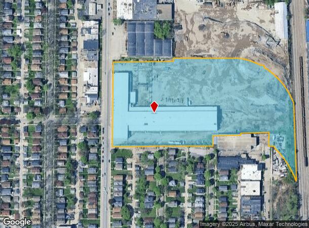
Property Record
3282 N 35Th St, Milwaukee, WI 53216
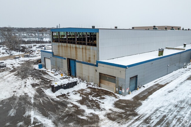
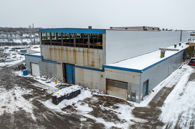

This Property Is For Sale
NEARBY LISTINGS FOR SALE OR LEASE
Property Detail
3282 N 35Th St
Milwaukee-Waukesha-West Allis, WI
Climax Subd
286-9996-113-4
LANDS IN SE 1/4 SEC 12-7-21 THAT PART OF LAND & LOT D IN PARTN COM 902.61 S & 30 E OF NW COR SD 1/4 SEC-TH E 337-TH N 17.5-TH E 363-TH SELY ALG A CUR 138.64-TH E 17.92-TH S 10.13-TH SELY ALG A CUR 247.49 TO W LI ROW-TH SLY 245 M/L-TH W 145.14-TH N 74
Warehouse
Milwaukee
X
Wisconsin
55079C0100E
d
2024
10.71 AC
2024
Milwaukee West
006300
Milwaukee/Madison
101,410 SF
DEMOGRAPHICS near 3282 N 35Th St
1 Mile
3 Mile
5 Mile
2024 Total Population
28,202
219,037
473,517
2029 Population
28,148
216,851
465,746
Pop Growth 2024-2029
(0.19%)
(1.00%)
(1.64%)
Average Age
36
35
36
2024 Total Households
10,591
88,183
198,502
HH Growth 2024-2029
(0.42%)
(1.12%)
(1.67%)
Median Household Inc
$31,808
$37,574
$48,122
Avg Household Size
2.50
2.30
2.30
2024 Avg HH Vehicles
1.00
1.00
1.00
Median Home Value
$80,881
$134,187
$182,925
Median Year Built
1946
1948
1949
Nearby Places
- Restaurants
- Banks
- Shops
- Fitness
- Groceries
PUBLIC TRANSPORTATION
COMMUTER RAIL
Milwaukee (Empire Builder - Amtrak)
DRIVE
WALK
Distance
Milwaukee (Empire Builder - Amtrak)
11 min
4.1 mi
AIRPORT
General Mitchell International
DRIVE
WALK
Distance
General Mitchell International
22 min
10.7 mi
Freight Ports
Port Milwaukee
DRIVE
WALK
Distance
Port Milwaukee
14 min
6.6 mi
Nearby Properties
Address
Land Use
TOTAL SIZE
Lot Size
Zoning
Address
Land Use
TOTAL SIZE
Lot Size
Zoning
3.04 AC
TL
Address
Land Use
TOTAL SIZE
Lot Size
Zoning
280,000 SF
2.74 AC
RED
Address
Land Use
TOTAL SIZE
Lot Size
Zoning
262,109 SF
2.24 AC
PD
Address
Land Use
TOTAL SIZE
Lot Size
Zoning
66,245 SF
10.21 AC
Address
Land Use
TOTAL SIZE
Lot Size
Zoning
0.09 AC
LB2
Address
Land Use
TOTAL SIZE
Lot Size
Zoning
0.07 AC
RS6
Address
Land Use
TOTAL SIZE
Lot Size
Zoning
15.43 AC
PD
Address
Land Use
TOTAL SIZE
Lot Size
Zoning
685,390 SF
26.20 AC
Address
Land Use
TOTAL SIZE
Lot Size
Zoning
152,640 SF
10.50 AC
Address
Land Use
TOTAL SIZE
Lot Size
Zoning
150,370 SF
2.46 AC
C9G
Address
Land Use
TOTAL SIZE
Lot Size
Zoning
171,170 SF
25.88 AC
Address
Land Use
TOTAL SIZE
Lot Size
Zoning
12.74 AC
TL
Address
Land Use
TOTAL SIZE
Lot Size
Zoning
189,063 SF
2.35 AC
RED
Address
Land Use
TOTAL SIZE
Lot Size
Zoning
193,988 SF
1.28 AC
C9G
Address
Land Use
TOTAL SIZE
Lot Size
Zoning
224,756 SF
12 AC
RESIDENTIA
Address
Land Use
TOTAL SIZE
Lot Size
Zoning
0.71 AC
RM2
Address
Land Use
TOTAL SIZE
Lot Size
Zoning
0.71 AC
RM2
Address
Land Use
TOTAL SIZE
Lot Size
Zoning
241,520 SF
6.60 AC
Address
Land Use
TOTAL SIZE
Lot Size
Zoning
9.33 AC
PUD
Address
Land Use
TOTAL SIZE
Lot Size
Zoning
78,210 SF
2.36 AC
PD
Address
Land Use
TOTAL SIZE
Lot Size
Zoning
3.74 AC
PUD
Address
Land Use
TOTAL SIZE
Lot Size
Zoning
150,107 SF
1.18 AC
C9G
Address
Land Use
TOTAL SIZE
Lot Size
Zoning
1.76 AC
LB2
Address
Land Use
TOTAL SIZE
Lot Size
Zoning
92,402 SF
0.87 AC
RED
Address
Land Use
TOTAL SIZE
Lot Size
Zoning
109,008 SF
0.46 AC
PD
Address
Land Use
TOTAL SIZE
Lot Size
Zoning
8.78 AC
Address
Land Use
TOTAL SIZE
Lot Size
Zoning
4.25 AC
PD
Address
Land Use
TOTAL SIZE
Lot Size
Zoning
0.80 AC
RT4
Address
Land Use
TOTAL SIZE
Lot Size
Zoning
2.15 AC
RT4
Address
Land Use
TOTAL SIZE
Lot Size
Zoning
89,658 SF
0.99 AC
C9A(A)
The World's #1 Commercial Real Estate Marketplace
Connect with us
© 2025 CoStar Group
The information above has been obtained from sources believed reliable. While we do not doubt its accuracy we have not verified it and make no guarantee, warranty or representation about it. It is your responsibility to independently confirm its accuracy and completeness. Any projections, opinions, assumptions, or estimates used are for example only and do not represent the current or future performance of the property. The value of this transaction to you depends on tax and other factors which should be evaluated by your tax, financial, and legal advisors. You and your advisors should conduct a careful, independent investigation of the property to determine to your satisfaction the suitability of the property for your needs.