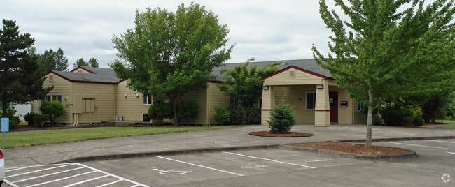
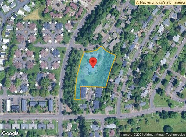
Property Record
3285 Ne Oxford Cir, Corvallis, OR 97330

NEARBY LISTINGS FOR SALE OR LEASE
Property Detail
3285 Ne Oxford Cir
359148
LOT 1
Taxexempt
Benton
AE
Oregon
41003C0201F
1
0
2.36 AC
2025
Oregon West Area
000600
Other Market Areas
10,192 SF
Corvallis, OR
DEMOGRAPHICS near 3285 Ne Oxford Cir
1 Mile
3 Mile
5 Mile
2024 Total Population
6,005
37,594
68,548
2029 Population
6,302
39,628
72,160
Pop Growth 2024-2029
+ 4.95%
+ 5.41%
+ 5.27%
Average Age
42
39
37
2024 Total Households
2,616
15,905
27,332
HH Growth 2024-2029
+ 5.24%
+ 5.79%
+ 5.86%
Median Household Inc
$53,831
$58,309
$59,595
Avg Household Size
2.20
2.20
2.20
2024 Avg HH Vehicles
1.00
2.00
2.00
Median Home Value
$296,216
$425,789
$440,173
Median Year Built
1981
1973
1976
Nearby Places
Map Layers
Map Styles
 Street
 Aerial
- Restaurants
- Banks
- Shops
- Fitness
- Groceries
PUBLIC TRANSPORTATION
COMMUTER RAIL
DRIVE
WALK
Distance
17 min
9.4 mi
AIRPORT
Mahlon Sweet Field
DRIVE
WALK
Distance
Mahlon Sweet Field
64 min
40.2 mi
Nearby Properties
Address
Land Use
TOTAL SIZE
Lot Size
Zoning
Address
Land Use
TOTAL SIZE
Lot Size
Zoning
Address
Land Use
TOTAL SIZE
Lot Size
Zoning
Address
Land Use
TOTAL SIZE
Lot Size
Zoning
298,527 SF
32.61 AC
PD(RS-3.5)
Address
Land Use
TOTAL SIZE
Lot Size
Zoning
247,098 SF
16.39 AC
OSU
Address
Land Use
TOTAL SIZE
Lot Size
Zoning
321,584 SF
21.48 AC
RS-9
Address
Land Use
TOTAL SIZE
Lot Size
Zoning
195,325 SF
26.28 AC
RS-3.5
Address
Land Use
TOTAL SIZE
Lot Size
Zoning
866,072 SF
52.82 AC
P
Address
Land Use
TOTAL SIZE
Lot Size
Zoning
339,006 SF
0.69 AC
RF
Address
Land Use
TOTAL SIZE
Lot Size
Zoning
Address
Land Use
TOTAL SIZE
Lot Size
Zoning
20.84 AC
GI
Address
Land Use
TOTAL SIZE
Lot Size
Zoning
47,966 SF
2.44 AC
RS-9
Address
Land Use
TOTAL SIZE
Lot Size
Zoning
176,703 SF
3.43 AC
OSU
Address
Land Use
TOTAL SIZE
Lot Size
Zoning
116,863 SF
2.10 AC
OSU
Address
Land Use
TOTAL SIZE
Lot Size
Zoning
81,113 SF
1.81 AC
PD(RS-20)
Address
Land Use
TOTAL SIZE
Lot Size
Zoning
129,103 SF
6.95 AC
PD(RS-12)
Address
Land Use
TOTAL SIZE
Lot Size
Zoning
85,211 SF
1.15 AC
PD(RS-3.5)
Address
Land Use
TOTAL SIZE
Lot Size
Zoning
146,932 SF
6.41 AC
MUCS
Address
Land Use
TOTAL SIZE
Lot Size
Zoning
74,046 SF
9.53 AC
PD(RS-3.5)
Address
Land Use
TOTAL SIZE
Lot Size
Zoning
112,216 SF
11.30 AC
PD(NC-MAJO
Address
Land Use
TOTAL SIZE
Lot Size
Zoning
192,991 SF
10.19 AC
GI
Address
Land Use
TOTAL SIZE
Lot Size
Zoning
122,984 SF
2.56 AC
RS-20
Address
Land Use
TOTAL SIZE
Lot Size
Zoning
57,607 SF
29.70 AC
PD(RS-3.5)
Address
Land Use
TOTAL SIZE
Lot Size
Zoning
95,797 SF
6.03 AC
PD(P-AO)
Address
Land Use
TOTAL SIZE
Lot Size
Zoning
300,108 SF
11.08 AC
PD(GI)
Address
Land Use
TOTAL SIZE
Lot Size
Zoning
166,396 SF
4.96 AC
GI
Address
Land Use
TOTAL SIZE
Lot Size
Zoning
3,486 SF
14 AC
OSU
Address
Land Use
TOTAL SIZE
Lot Size
Zoning
169.68 AC
PD(GI)
Address
Land Use
TOTAL SIZE
Lot Size
Zoning
139,752 SF
7.60 AC
RS-12
Address
Land Use
TOTAL SIZE
Lot Size
Zoning
57,180 SF
11.57 AC
RS-3.5
Address
Land Use
TOTAL SIZE
Lot Size
Zoning
46,056 SF
1.48 AC
CB
The World's #1 Commercial Real Estate Marketplace
Connect with us
© 2026 CoStar Group
The information above has been obtained from sources believed reliable. While we do not doubt its accuracy we have not verified it and make no guarantee, warranty or representation about it. It is your responsibility to independently confirm its accuracy and completeness. Any projections, opinions, assumptions, or estimates used are for example only and do not represent the current or future performance of the property. The value of this transaction to you depends on tax and other factors which should be evaluated by your tax, financial, and legal advisors. You and your advisors should conduct a careful, independent investigation of the property to determine to your satisfaction the suitability of the property for your needs.