Property Record
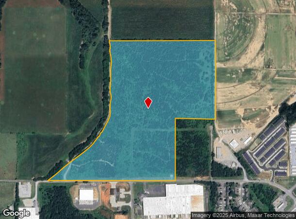
329 Brown Farm Rd Sw, Cartersville, GA 30120
NEARBY LISTINGS FOR SALE OR LEASE
Property Detail
329 Brown Farm Rd Sw
Atlanta-Sandy Springs-Roswell, GA
Com - West/Highway 113
C054-0801-001
LL784-785,800-801 D4 S 3
Industrialacreage
Bartow
AE
Georgia
13015C0263H
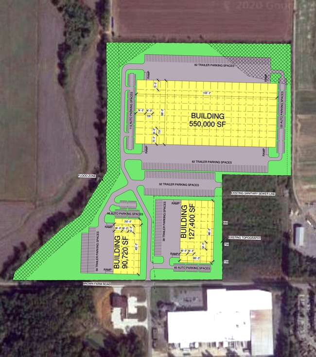
57.89 AC
2024
Bartow County
2025
Atlanta
960901
DEMOGRAPHICS near 329 Brown Farm Rd Sw
1 Mile
3 Mile
5 Mile
2024 Total Population
812
10,848
34,769
2029 Population
870
11,881
38,095
Pop Growth 2024-2029
+ 7.14%
+ 9.52%
+ 9.57%
Average Age
38
39
39
2024 Total Households
295
3,956
12,737
HH Growth 2024-2029
+ 6.78%
+ 9.30%
+ 9.33%
Median Household Inc
$89,666
$84,089
$76,668
Avg Household Size
2.70
2.70
2.60
2024 Avg HH Vehicles
2.00
2.00
2.00
Median Home Value
$205,970
$248,243
$244,922
Median Year Built
1990
1992
1990
Nearby Places
Map Layers
Map Styles
 Street
 Aerial
- Restaurants
- Banks
- Shops
- Fitness
- Groceries
SALE & LEASE HISTORY
LISTING DATE
SALE/LEASE

Mar 15, 2021
For Sale
Nearby Properties
Address
Land Use
TOTAL SIZE
Lot Size
Zoning
Address
Land Use
TOTAL SIZE
Lot Size
Zoning
226,108 SF
33.73 AC
Address
Land Use
TOTAL SIZE
Lot Size
Zoning
196,710 SF
149.63 AC
Address
Land Use
TOTAL SIZE
Lot Size
Zoning
149,158 SF
46.23 AC
IN
Address
Land Use
TOTAL SIZE
Lot Size
Zoning
1,800 SF
102.03 AC
A1
Address
Land Use
TOTAL SIZE
Lot Size
Zoning
24,991 SF
25.20 AC
Address
Land Use
TOTAL SIZE
Lot Size
Zoning
58,757 SF
22.63 AC
A1
Address
Land Use
TOTAL SIZE
Lot Size
Zoning
57,164 SF
4.88 AC
Address
Land Use
TOTAL SIZE
Lot Size
Zoning
34,786 SF
12.23 AC
IN
Address
Land Use
TOTAL SIZE
Lot Size
Zoning
128.74 AC
A1
Address
Land Use
TOTAL SIZE
Lot Size
Zoning
61,132 SF
5.39 AC
Address
Land Use
TOTAL SIZE
Lot Size
Zoning
189 AC
A1
Address
Land Use
TOTAL SIZE
Lot Size
Zoning
211,879 SF
23.57 AC
IN
Address
Land Use
TOTAL SIZE
Lot Size
Zoning
67,579 SF
18.97 AC
IN
Address
Land Use
TOTAL SIZE
Lot Size
Zoning
2,632 SF
52.90 AC
IN
Address
Land Use
TOTAL SIZE
Lot Size
Zoning
40,000 SF
18.15 AC
Address
Land Use
TOTAL SIZE
Lot Size
Zoning
313,640 SF
24.12 AC
IN
Address
Land Use
TOTAL SIZE
Lot Size
Zoning
242,214 SF
14.71 AC
IN
Address
Land Use
TOTAL SIZE
Lot Size
Zoning
23,560 SF
11.28 AC
IN
Address
Land Use
TOTAL SIZE
Lot Size
Zoning
15,453 SF
6.16 AC
IN
Address
Land Use
TOTAL SIZE
Lot Size
Zoning
147,500 SF
14.60 AC
IN
Address
Land Use
TOTAL SIZE
Lot Size
Zoning
36.03 AC
IN
Address
Land Use
TOTAL SIZE
Lot Size
Zoning
98,691 SF
12.08 AC
Address
Land Use
TOTAL SIZE
Lot Size
Zoning
70,122 SF
6.10 AC
Address
Land Use
TOTAL SIZE
Lot Size
Zoning
85 AC
INDUSTRIAL
Address
Land Use
TOTAL SIZE
Lot Size
Zoning
58,074 SF
20.28 AC
I1
Address
Land Use
TOTAL SIZE
Lot Size
Zoning
30,000 SF
53.17 AC
IN
Address
Land Use
TOTAL SIZE
Lot Size
Zoning
6,980 SF
202.44 AC
IN
Address
Land Use
TOTAL SIZE
Lot Size
Zoning
18,730 SF
5.40 AC
IN
Address
Land Use
TOTAL SIZE
Lot Size
Zoning
31,871 SF
10.91 AC
IN
Address
Land Use
TOTAL SIZE
Lot Size
Zoning
110,924 SF
18.72 AC
IN
The World's #1 Commercial Real Estate Marketplace
Connect with us
© 2026 CoStar Group
The information above has been obtained from sources believed reliable. While we do not doubt its accuracy we have not verified it and make no guarantee, warranty or representation about it. It is your responsibility to independently confirm its accuracy and completeness. Any projections, opinions, assumptions, or estimates used are for example only and do not represent the current or future performance of the property. The value of this transaction to you depends on tax and other factors which should be evaluated by your tax, financial, and legal advisors. You and your advisors should conduct a careful, independent investigation of the property to determine to your satisfaction the suitability of the property for your needs.