Property Record
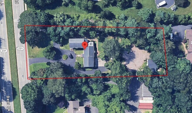
327 Deer Park Rd, Dix Hills, NY 11746
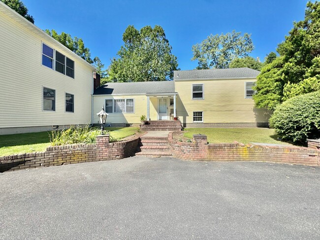

This Property Is For Sale
NEARBY LISTINGS FOR SALE OR LEASE
Property Detail
327 Deer Park Rd
Long Island (New York)
Described
Nassau County-Suffolk County, NY
Suffolk
0400-247-00-01-00-107-000
New York
Sfr
1.16 AC
X
Western Suffolk
36103C0630H
DEMOGRAPHICS near 327 Deer Park Rd
1 Mile
3 Mile
5 Mile
2024 Total Population
4,168
62,242
217,292
2029 Population
4,155
61,841
214,240
Pop Growth 2024-2029
(0.31%)
(0.64%)
(1.40%)
Average Age
43
43
41
2024 Total Households
1,258
19,783
67,709
HH Growth 2024-2029
(0.48%)
(0.93%)
(1.63%)
Median Household Inc
$225,623
$173,690
$150,156
Avg Household Size
3.20
3.00
3.00
2024 Avg HH Vehicles
3.00
2.00
2.00
Median Home Value
$921,011
$776,291
$703,317
Median Year Built
1968
1965
1963
Nearby Places
- Restaurants
- Banks
- Shops
- Fitness
- Groceries
PUBLIC TRANSPORTATION
COMMUTER RAIL
Wyandanch Station (Ronkonkoma Branch - Long Island Rail Road)
DRIVE
WALK
Distance
Wyandanch Station (Ronkonkoma Branch - Long Island Rail Road)
9 min
4.9 mi
Greenlawn Station (Port Jefferson Branch - Long Island Rail Road)
DRIVE
WALK
Distance
Greenlawn Station (Port Jefferson Branch - Long Island Rail Road)
11 min
5.0 mi
AIRPORT
Long Island MacArthur
DRIVE
WALK
Distance
Long Island MacArthur
23 min
15.0 mi
John F Kennedy International
DRIVE
WALK
Distance
John F Kennedy International
49 min
33.0 mi
Freight Ports
NY - Red Hook Container Terminal
DRIVE
WALK
Distance
NY - Red Hook Container Terminal
61 min
41.0 mi
Nearby Properties
Address
Land Use
TOTAL SIZE
Lot Size
Zoning
Address
Land Use
TOTAL SIZE
Lot Size
Zoning
0.41 AC
VILLA
Address
Land Use
TOTAL SIZE
Lot Size
Zoning
1.50 AC
CR80
Address
Land Use
TOTAL SIZE
Lot Size
Zoning
21.50 AC
Address
Land Use
TOTAL SIZE
Lot Size
Zoning
82 AC
R40
Address
Land Use
TOTAL SIZE
Lot Size
Zoning
14.13 AC
Address
Land Use
TOTAL SIZE
Lot Size
Zoning
Address
Land Use
TOTAL SIZE
Lot Size
Zoning
52.20 AC
R40
Address
Land Use
TOTAL SIZE
Lot Size
Zoning
88,200 SF
11.20 AC
Address
Land Use
TOTAL SIZE
Lot Size
Zoning
15.70 AC
Address
Land Use
TOTAL SIZE
Lot Size
Zoning
148.70 AC
R40
Address
Land Use
TOTAL SIZE
Lot Size
Zoning
30.30 AC
R40
Address
Land Use
TOTAL SIZE
Lot Size
Zoning
15.20 AC
Address
Land Use
TOTAL SIZE
Lot Size
Zoning
142,732 SF
16.90 AC
Address
Land Use
TOTAL SIZE
Lot Size
Zoning
12.80 AC
Address
Land Use
TOTAL SIZE
Lot Size
Zoning
44.70 AC
G
Address
Land Use
TOTAL SIZE
Lot Size
Zoning
19.90 AC
C5
Address
Land Use
TOTAL SIZE
Lot Size
Zoning
5.77 AC
R40
Address
Land Use
TOTAL SIZE
Lot Size
Zoning
160 AC
R40
Address
Land Use
TOTAL SIZE
Lot Size
Zoning
7.10 AC
Address
Land Use
TOTAL SIZE
Lot Size
Zoning
10.47 AC
Address
Land Use
TOTAL SIZE
Lot Size
Zoning
Address
Land Use
TOTAL SIZE
Lot Size
Zoning
180,224 SF
8.70 AC
GA
Address
Land Use
TOTAL SIZE
Lot Size
Zoning
9.80 AC
Address
Land Use
TOTAL SIZE
Lot Size
Zoning
48.76 AC
R40
Address
Land Use
TOTAL SIZE
Lot Size
Zoning
16.10 AC
C5
Address
Land Use
TOTAL SIZE
Lot Size
Zoning
Address
Land Use
TOTAL SIZE
Lot Size
Zoning
0.10 AC
R40
Address
Land Use
TOTAL SIZE
Lot Size
Zoning
0.46 AC
R15
Address
Land Use
TOTAL SIZE
Lot Size
Zoning
35.04 AC
R40
Address
Land Use
TOTAL SIZE
Lot Size
Zoning
10.30 AC
R40
The World's #1 Commercial Real Estate Marketplace
Connect with us
© 2025 CoStar Group
The information above has been obtained from sources believed reliable. While we do not doubt its accuracy we have not verified it and make no guarantee, warranty or representation about it. It is your responsibility to independently confirm its accuracy and completeness. Any projections, opinions, assumptions, or estimates used are for example only and do not represent the current or future performance of the property. The value of this transaction to you depends on tax and other factors which should be evaluated by your tax, financial, and legal advisors. You and your advisors should conduct a careful, independent investigation of the property to determine to your satisfaction the suitability of the property for your needs.