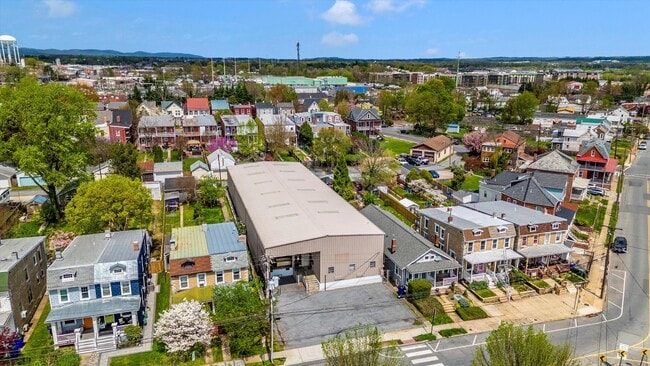
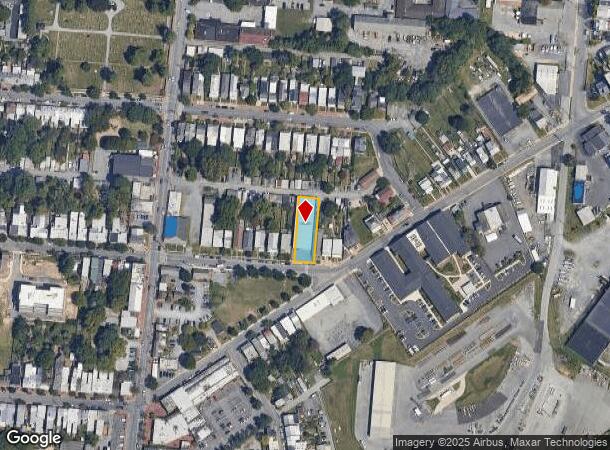
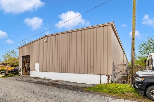
Property Record
329 E 2Nd St, Frederick, MD 21701
Current Lease Availabilities
Property Detail
329 E 2Nd St
Washington-Arlington-Alexandria, DC-VA-MD-WV
Frederick
02-079321
LTS 106-107-11393 SF 329 E 2ND ST FREDERICK
Warehouse
Frederick
X
Maryland
24021C0292E
106,1
2024
0.26 AC
2025
Frederick County
750200
Washington, DC
7,968 SF
NEARBY LISTINGS FOR SALE OR LEASE
DEMOGRAPHICS near 329 E 2Nd St
1 mile
3 mile
5 mile
2024 Total Population
13,208
82,922
143,960
2029 Population
15,124
94,197
163,909
Pop Growth 2024-2029
+ 14.51%
+ 13.60%
+ 13.86%
Average Age
41
38
39
2024 Total Households
6,305
32,768
54,338
HH Growth 2024-2029
+ 14.77%
+ 14.07%
+ 14.31%
Median Household Inc
$71,560
$81,079
$93,104
Avg Household Size
2.00
2.40
2.50
2024 Avg HH Vehicles
2.00
2.00
2.00
Median Home Value
$372,889
$319,615
$354,426
Median Year Built
1952
1988
1992
Nearby Places
Map Layers
Map Styles
 Street
 Aerial
Transit
 Traffic
 Biking
Places
Listings with unknown addresses are not visible on the map
- Restaurants
- Banks
- Shops
- Fitness
- Groceries
PUBLIC TRANSPORTATION
TRANSIT/SUBWAY
Frederick (Brunswick Line - Maryland Area Regional Commuter Trains (The MARC))
Drive
Walk
Distance
Frederick (Brunswick Line - Maryland Area Regional Commuter Trains (The MARC))
4 min
8 min
0.4 mi
COMMUTER RAIL
Drive
Walk
Distance
2 min
8 min
0.4 mi
Drive
Walk
Distance
8 min
3.2 mi
AIRPORT
Hagerstown Regional/Richard A Henson Field
Drive
Walk
Distance
Hagerstown Regional/Richard A Henson Field
44 min
32.0 mi
Washington Dulles International
Drive
Walk
Distance
Washington Dulles International
69 min
43.9 mi
Freight Ports
Port of Baltimore
Drive
Walk
Distance
Port of Baltimore
62 min
49.5 mi
Nearby Properties
Address
Land Use
TOTAL SIZE
Lot Size
Zoning
Address
Land Use
TOTAL SIZE
Lot Size
Zoning
1,368,786 SF
15.79 AC
IST
Address
Land Use
TOTAL SIZE
Lot Size
Zoning
3,545,442 SF
1.22 AC
IST
Address
Land Use
TOTAL SIZE
Lot Size
Zoning
551,652 SF
27.47 AC
M1
Address
Land Use
TOTAL SIZE
Lot Size
Zoning
336,506 SF
31.96 AC
MXE
Address
Land Use
TOTAL SIZE
Lot Size
Zoning
167,328 SF
617.27 AC
IST
Address
Land Use
TOTAL SIZE
Lot Size
Zoning
775,055 SF
47.98 AC
IST
Address
Land Use
TOTAL SIZE
Lot Size
Zoning
407,190 SF
43.36 AC
IST
Address
Land Use
TOTAL SIZE
Lot Size
Zoning
530,619 SF
100.32 AC
IST
Address
Land Use
TOTAL SIZE
Lot Size
Zoning
285,071 SF
16.34 AC
PND
Address
Land Use
TOTAL SIZE
Lot Size
Zoning
372,920 SF
15.54 AC
PUD
Address
Land Use
TOTAL SIZE
Lot Size
Zoning
458,419 SF
25.94 AC
IST
Address
Land Use
TOTAL SIZE
Lot Size
Zoning
360,260 SF
10.34 AC
R16
Address
Land Use
TOTAL SIZE
Lot Size
Zoning
719,578 SF
48.06 AC
GC
Address
Land Use
TOTAL SIZE
Lot Size
Zoning
689,832 SF
55.26 AC
M1
Address
Land Use
TOTAL SIZE
Lot Size
Zoning
398,032 SF
14.68 AC
MU1
Address
Land Use
TOTAL SIZE
Lot Size
Zoning
221,825 SF
0.39 AC
IST
Address
Land Use
TOTAL SIZE
Lot Size
Zoning
217,295 SF
23.68 AC
GC
Address
Land Use
TOTAL SIZE
Lot Size
Zoning
221,252 SF
8.07 AC
MU1
Address
Land Use
TOTAL SIZE
Lot Size
Zoning
264,028 SF
21.82 AC
R16
Address
Land Use
TOTAL SIZE
Lot Size
Zoning
234,017 SF
24.54 AC
GC
Address
Land Use
TOTAL SIZE
Lot Size
Zoning
540,148 SF
70.22 AC
MXE
Address
Land Use
TOTAL SIZE
Lot Size
Zoning
232,532 SF
11.15 AC
PND
Address
Land Use
TOTAL SIZE
Lot Size
Zoning
214,291 SF
88.13 AC
IST
Address
Land Use
TOTAL SIZE
Lot Size
Zoning
134,300 SF
12.62 AC
PUD
Address
Land Use
TOTAL SIZE
Lot Size
Zoning
129,448 SF
19.81 AC
PUD
Address
Land Use
TOTAL SIZE
Lot Size
Zoning
192,497 SF
7.53 AC
IST
Address
Land Use
TOTAL SIZE
Lot Size
Zoning
268,693 SF
14.33 AC
R20
Address
Land Use
TOTAL SIZE
Lot Size
Zoning
185,639 SF
22.94 AC
ORI
Address
Land Use
TOTAL SIZE
Lot Size
Zoning
122,807 SF
12 AC
Address
Land Use
TOTAL SIZE
Lot Size
Zoning
277,688 SF
28.05 AC
IST
The World's #1 Commercial Real Estate Marketplace
Connect with us
© 2026 CoStar Group
The information above has been obtained from sources believed reliable. While we do not doubt its accuracy we have not verified it and make no guarantee, warranty or representation about it. It is your responsibility to independently confirm its accuracy and completeness. Any projections, opinions, assumptions, or estimates used are for example only and do not represent the current or future performance of the property. The value of this transaction to you depends on tax and other factors which should be evaluated by your tax, financial, and legal advisors. You and your advisors should conduct a careful, independent investigation of the property to determine to your satisfaction the suitability of the property for your needs.