Property Record
329 Hamp Jones Rd, Carrollton, GA 30117
NEARBY LISTINGS FOR SALE OR LEASE
-
-
View all Carrollton listings for sale on LoopNet.com
Property Detail
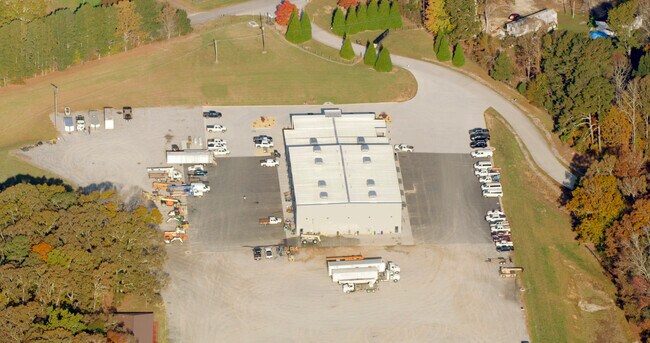
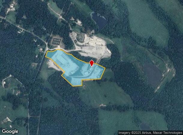
329 Hamp Jones Rd
070-0200
COMM IMP/11.24AC HAMP JONES RD
Officebuilding
Carroll
X
Georgia
13143C0250B
11.24 AC
2025
W Carroll County
2025
Atlanta
910301
Atlanta-Sandy Springs-Roswell, GA
29,600 SF
DEMOGRAPHICS near 329 Hamp Jones Rd
1 Mile
3 Mile
5 Mile
2024 Total Population
489
5,887
21,126
2029 Population
548
6,658
23,775
Pop Growth 2024-2029
+ 12.07%
+ 13.10%
+ 12.54%
Average Age
40
38
38
2024 Total Households
177
2,086
7,608
HH Growth 2024-2029
+ 11.86%
+ 13.18%
+ 12.59%
Median Household Inc
$63,821
$57,423
$60,396
Avg Household Size
2.70
2.80
2.70
2024 Avg HH Vehicles
3.00
2.00
2.00
Median Home Value
$308,333
$211,486
$199,188
Median Year Built
1988
1990
1991
Nearby Places
Map Layers
Map Styles
 Street
 Aerial
- Restaurants
- Banks
- Shops
- Fitness
- Groceries
Nearby Properties
Address
Land Use
TOTAL SIZE
Lot Size
Zoning
Address
Land Use
TOTAL SIZE
Lot Size
Zoning
932,068 SF
150.44 AC
I
Address
Land Use
TOTAL SIZE
Lot Size
Zoning
256,320 SF
38.83 AC
003
Address
Land Use
TOTAL SIZE
Lot Size
Zoning
86,316 SF
12.85 AC
C2
Address
Land Use
TOTAL SIZE
Lot Size
Zoning
109,300 SF
127 AC
I
Address
Land Use
TOTAL SIZE
Lot Size
Zoning
22,780 SF
1.36 AC
C2
Address
Land Use
TOTAL SIZE
Lot Size
Zoning
39,050 SF
6.75 AC
001
Address
Land Use
TOTAL SIZE
Lot Size
Zoning
28,186 SF
8 AC
C
Address
Land Use
TOTAL SIZE
Lot Size
Zoning
11,900 SF
2.48 AC
C
Address
Land Use
TOTAL SIZE
Lot Size
Zoning
49,976 SF
3.75 AC
C
Address
Land Use
TOTAL SIZE
Lot Size
Zoning
29,600 SF
3.73 AC
C
Address
Land Use
TOTAL SIZE
Lot Size
Zoning
12,172 SF
1.03 AC
002
Address
Land Use
TOTAL SIZE
Lot Size
Zoning
22,552 SF
3.74 AC
002
Address
Land Use
TOTAL SIZE
Lot Size
Zoning
22,572 SF
2.62 AC
C
Address
Land Use
TOTAL SIZE
Lot Size
Zoning
51,408 SF
4.69 AC
C
Address
Land Use
TOTAL SIZE
Lot Size
Zoning
26,348 SF
5.50 AC
C
Address
Land Use
TOTAL SIZE
Lot Size
Zoning
8,130 SF
1.21 AC
C
Address
Land Use
TOTAL SIZE
Lot Size
Zoning
47,320 SF
17.84 AC
C
Address
Land Use
TOTAL SIZE
Lot Size
Zoning
9,804 SF
3.84 AC
C
Address
Land Use
TOTAL SIZE
Lot Size
Zoning
4,950 SF
1.76 AC
C2
Address
Land Use
TOTAL SIZE
Lot Size
Zoning
11,214 SF
2.02 AC
001
Address
Land Use
TOTAL SIZE
Lot Size
Zoning
50,000 SF
3.84 AC
003
Address
Land Use
TOTAL SIZE
Lot Size
Zoning
11,496 SF
8 AC
002
Address
Land Use
TOTAL SIZE
Lot Size
Zoning
17.02 AC
002
Address
Land Use
TOTAL SIZE
Lot Size
Zoning
4,827 SF
1.60 AC
RESIDENTIA
Address
Land Use
TOTAL SIZE
Lot Size
Zoning
15,000 SF
18.55 AC
C
Address
Land Use
TOTAL SIZE
Lot Size
Zoning
11,241 SF
2 AC
002
Address
Land Use
TOTAL SIZE
Lot Size
Zoning
20,100 SF
3.27 AC
C2
Address
Land Use
TOTAL SIZE
Lot Size
Zoning
13,278 SF
1.86 AC
C
Address
Land Use
TOTAL SIZE
Lot Size
Zoning
5,530 SF
1 AC
C
The World's #1 Commercial Real Estate Marketplace
Connect with us
© 2025 CoStar Group
The information above has been obtained from sources believed reliable. While we do not doubt its accuracy we have not verified it and make no guarantee, warranty or representation about it. It is your responsibility to independently confirm its accuracy and completeness. Any projections, opinions, assumptions, or estimates used are for example only and do not represent the current or future performance of the property. The value of this transaction to you depends on tax and other factors which should be evaluated by your tax, financial, and legal advisors. You and your advisors should conduct a careful, independent investigation of the property to determine to your satisfaction the suitability of the property for your needs.