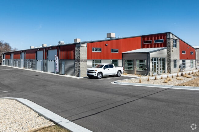
Property Record
1839 W 3300 S, Ogden, UT 84401

Current Lease Availabilities
Property Detail
1839 W 3300 S
15-102-0032
PART OF THE SOUTHWEST QUARTER OF SECTION 36, TOWNSHIP 6 NORTH RANGE 2 WEST, SALT LAKE BASE AND MERIDIAN, U.S. SURVEY:
Industrialgeneral
WEBER
B and X Area of moderate flood hazard, usually the area between the limits of the 100-year and 500-year floods.
Utah
2025
1.50 AC
2025
Davis North
201900
Salt Lake City
21,882 SF
Ogden, UT
NEARBY LISTINGS FOR SALE OR LEASE
DEMOGRAPHICS near 1839 W 3300 S
1 mile
3 mile
5 mile
2025 Total Population
5,605
59,733
184,046
2030 Population
5,911
62,481
190,491
Pop Growth 2025-2030
+ 5.46%
+ 4.60%
+ 3.50%
Average Age
35
36
36
2025 Total Households
2,199
20,515
64,122
HH Growth 2025-2030
+ 5.32%
+ 4.84%
+ 3.78%
Median Household Inc
$85,910
$84,401
$83,276
Avg Household Size
2.50
2.80
2.80
2025 Avg HH Vehicles
2.00
2.00
2.00
Median Home Value
$399,616
$404,301
$408,771
Median Year Built
2006
1990
1980
Nearby Places
Map Layers
Map Styles
 Street
 Aerial
Layers
 Traffic
 Biking
Places
Listings with unknown addresses are not visible on the map
- Restaurants
- Banks
- Shops
- Fitness
- Groceries
PUBLIC TRANSPORTATION
COMMUTER RAIL
Roy (FrontRunner North - Utah Transit Authority (UTA))
Drive
Walk
Distance
Roy (FrontRunner North - Utah Transit Authority (UTA))
4 min
2.0 mi
Ogden (FrontRunner North - Utah Transit Authority (UTA))
Drive
Walk
Distance
Ogden (FrontRunner North - Utah Transit Authority (UTA))
9 min
4.8 mi
AIRPORT
Salt Lake City International
Drive
Walk
Distance
Salt Lake City International
46 min
37.0 mi
Freight Ports
Port of Stockton
Drive
Walk
Distance
Port of Stockton
746 min
727.4 mi
Nearby Properties
Address
Land Use
TOTAL SIZE
Lot Size
Zoning
Address
Land Use
TOTAL SIZE
Lot Size
Zoning
2,657 SF
16.26 AC
Address
Land Use
TOTAL SIZE
Lot Size
Zoning
3,743 SF
8.80 AC
Address
Land Use
TOTAL SIZE
Lot Size
Zoning
841,756 SF
45.79 AC
Address
Land Use
TOTAL SIZE
Lot Size
Zoning
35,219 SF
58.98 AC
Address
Land Use
TOTAL SIZE
Lot Size
Zoning
7,492 SF
8.96 AC
Address
Land Use
TOTAL SIZE
Lot Size
Zoning
71,940 SF
11 AC
Address
Land Use
TOTAL SIZE
Lot Size
Zoning
21,684 SF
8.38 AC
Address
Land Use
TOTAL SIZE
Lot Size
Zoning
48,177 SF
5.54 AC
Address
Land Use
TOTAL SIZE
Lot Size
Zoning
106,752 SF
10.35 AC
Address
Land Use
TOTAL SIZE
Lot Size
Zoning
8,580 SF
6.40 AC
Address
Land Use
TOTAL SIZE
Lot Size
Zoning
66,896 SF
7.50 AC
Address
Land Use
TOTAL SIZE
Lot Size
Zoning
101,191 SF
4.14 AC
Address
Land Use
TOTAL SIZE
Lot Size
Zoning
119,043 SF
2.05 AC
Address
Land Use
TOTAL SIZE
Lot Size
Zoning
95,949 SF
3.29 AC
Address
Land Use
TOTAL SIZE
Lot Size
Zoning
149,400 SF
26.88 AC
Address
Land Use
TOTAL SIZE
Lot Size
Zoning
115,094 SF
13.88 AC
Address
Land Use
TOTAL SIZE
Lot Size
Zoning
166,800 SF
0.12 AC
Address
Land Use
TOTAL SIZE
Lot Size
Zoning
225,497 SF
20.33 AC
Address
Land Use
TOTAL SIZE
Lot Size
Zoning
19,594 SF
1.12 AC
Address
Land Use
TOTAL SIZE
Lot Size
Zoning
255,596 SF
15.98 AC
Address
Land Use
TOTAL SIZE
Lot Size
Zoning
99,775 SF
6.32 AC
The World's #1 Commercial Real Estate Marketplace
Connect with us
© 2026 CoStar Group
The information above has been obtained from sources believed reliable. While we do not doubt its accuracy we have not verified it and make no guarantee, warranty or representation about it. It is your responsibility to independently confirm its accuracy and completeness. Any projections, opinions, assumptions, or estimates used are for example only and do not represent the current or future performance of the property. The value of this transaction to you depends on tax and other factors which should be evaluated by your tax, financial, and legal advisors. You and your advisors should conduct a careful, independent investigation of the property to determine to your satisfaction the suitability of the property for your needs.