Property Record
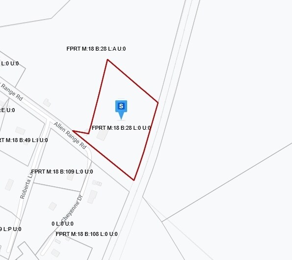
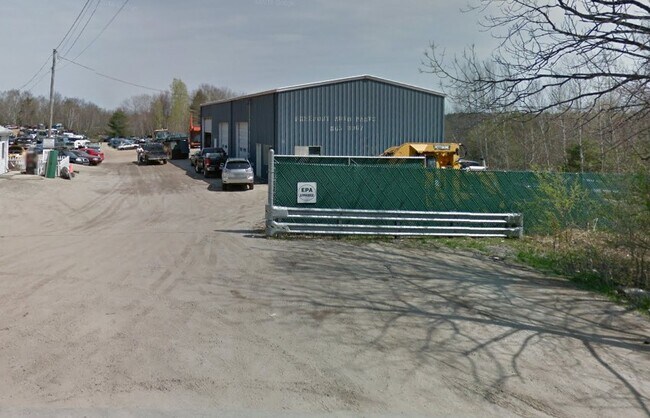
33 Allen Range Rd, Freeport, ME 04032

Property Detail
33 Allen Range Rd
Vehiclerentalsvehiclesales
Cumberland
CM05
Maine
B and X Area of moderate flood hazard, usually the area between the limits of the 100-year and 500-year floods.
10.15 AC
2025
NE Cumberland County
2025
Portland/South Portland
004502
Portland-South Portland, ME
3,000 SF
FPRT-000018-000028
NEARBY LISTINGS FOR SALE OR LEASE
DEMOGRAPHICS near 33 Allen Range Rd
1 mile
3 mile
5 mile
2025 Total Population
518
5,582
19,440
2030 Population
526
5,682
19,784
Pop Growth 2025-2030
+ 1.54%
+ 1.79%
+ 1.77%
Average Age
44
44
45
2025 Total Households
200
2,224
8,131
HH Growth 2025-2030
+ 1.50%
+ 1.93%
+ 1.80%
Median Household Inc
$119,642
$111,814
$100,210
Avg Household Size
2.60
2.40
2.20
2025 Avg HH Vehicles
2.00
2.00
2.00
Median Home Value
$644,117
$499,857
$448,275
Median Year Built
1984
1983
1980
Nearby Places
Map Layers
Map Styles
 Street
 Aerial
Transit
 Traffic
 Biking
Places
Listings with unknown addresses are not visible on the map
- Restaurants
- Banks
- Shops
- Fitness
- Groceries
PUBLIC TRANSPORTATION
COMMUTER RAIL
Drive
Walk
Distance
8 min
3.6 mi
Drive
Walk
Distance
13 min
6.6 mi
AIRPORT
Portland International Jetport
Drive
Walk
Distance
Portland International Jetport
37 min
24.2 mi
Freight Ports
Portland, ME
Drive
Walk
Distance
Portland, ME
30 min
21.2 mi
Nearby Properties
Address
Land Use
TOTAL SIZE
Lot Size
Zoning
Address
Land Use
TOTAL SIZE
Lot Size
Zoning
3.63 AC
CM01
Address
Land Use
TOTAL SIZE
Lot Size
Zoning
24 AC
CM02
Address
Land Use
TOTAL SIZE
Lot Size
Zoning
7.53 AC
CM01
Address
Land Use
TOTAL SIZE
Lot Size
Zoning
5.15 AC
CM03
Address
Land Use
TOTAL SIZE
Lot Size
Zoning
1.46 AC
CM03
Address
Land Use
TOTAL SIZE
Lot Size
Zoning
45,829 SF
0.94 AC
CM01
Address
Land Use
TOTAL SIZE
Lot Size
Zoning
58,718 SF
13 AC
CM03
Address
Land Use
TOTAL SIZE
Lot Size
Zoning
60,270 SF
21.80 AC
CM03
Address
Land Use
TOTAL SIZE
Lot Size
Zoning
Address
Land Use
TOTAL SIZE
Lot Size
Zoning
29,680 SF
0.79 AC
CM01
Address
Land Use
TOTAL SIZE
Lot Size
Zoning
1.01 AC
CM02
Address
Land Use
TOTAL SIZE
Lot Size
Zoning
2,189 SF
3.63 AC
CM01
Address
Land Use
TOTAL SIZE
Lot Size
Zoning
0.62 AC
CM01
Address
Land Use
TOTAL SIZE
Lot Size
Zoning
3.89 AC
CM03
Address
Land Use
TOTAL SIZE
Lot Size
Zoning
16,089 SF
0.33 AC
CM02
Address
Land Use
TOTAL SIZE
Lot Size
Zoning
35 AC
550
Address
Land Use
TOTAL SIZE
Lot Size
Zoning
4,995 SF
0.40 AC
CM01
Address
Land Use
TOTAL SIZE
Lot Size
Zoning
0.39 AC
CM01
Address
Land Use
TOTAL SIZE
Lot Size
Zoning
26,954 SF
5.56 AC
CM03
Address
Land Use
TOTAL SIZE
Lot Size
Zoning
4.16 AC
900
Address
Land Use
TOTAL SIZE
Lot Size
Zoning
14 AC
CM03
Address
Land Use
TOTAL SIZE
Lot Size
Zoning
15,170 SF
0.29 AC
CM01
Address
Land Use
TOTAL SIZE
Lot Size
Zoning
8,681 SF
0.35 AC
CM02
Address
Land Use
TOTAL SIZE
Lot Size
Zoning
16,278 SF
9.30 AC
CM03
Address
Land Use
TOTAL SIZE
Lot Size
Zoning
5,225 SF
0.17 AC
CM01
Address
Land Use
TOTAL SIZE
Lot Size
Zoning
24,779 SF
0.88 AC
CM03
Address
Land Use
TOTAL SIZE
Lot Size
Zoning
9,153 SF
0.26 AC
CM02
Address
Land Use
TOTAL SIZE
Lot Size
Zoning
22,974 SF
2.19 AC
CM05
Address
Land Use
TOTAL SIZE
Lot Size
Zoning
8,595 SF
0.23 AC
CM01
Address
Land Use
TOTAL SIZE
Lot Size
Zoning
18,926 SF
1.45 AC
CM03
The World's #1 Commercial Real Estate Marketplace
Connect with us
© 2026 CoStar Group
The information above has been obtained from sources believed reliable. While we do not doubt its accuracy we have not verified it and make no guarantee, warranty or representation about it. It is your responsibility to independently confirm its accuracy and completeness. Any projections, opinions, assumptions, or estimates used are for example only and do not represent the current or future performance of the property. The value of this transaction to you depends on tax and other factors which should be evaluated by your tax, financial, and legal advisors. You and your advisors should conduct a careful, independent investigation of the property to determine to your satisfaction the suitability of the property for your needs.