Property Record
33 Border Way, West Springfield, MA 01089
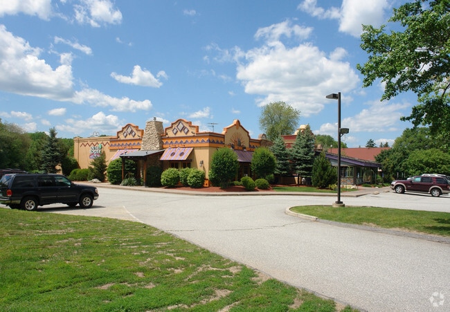

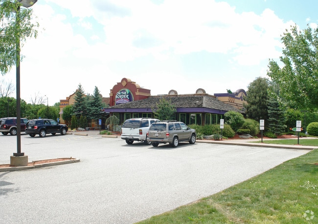
Property Detail
33 Border Way
Springfield, MA
Hampden
WSPR-000226-008440-J000002
Massachusetts
Restaurantbuilding
j2
2025
6.17 AC
2025
Hampden County
812202
Hartford
8,702 SF
NEARBY LISTINGS FOR SALE OR LEASE
DEMOGRAPHICS near 33 Border Way
1 mile
3 mile
5 mile
2025 Total Population
3,920
80,827
201,153
2030 Population
3,907
80,366
200,504
Pop Growth 2025-2030
(0.33%)
(0.57%)
(0.32%)
Average Age
42
40
39
2025 Total Households
1,930
33,330
80,119
HH Growth 2025-2030
(0.31%)
(0.56%)
(0.34%)
Median Household Inc
$52,129
$51,887
$51,697
Avg Household Size
2.00
2.30
2.40
2025 Avg HH Vehicles
1.00
1.00
1.00
Median Home Value
$364,322
$284,940
$276,946
Median Year Built
1966
1952
1951
Nearby Places
Map Layers
Map Styles
 Street
 Aerial
Transit
 Traffic
 Biking
Places
Listings with unknown addresses are not visible on the map
- Restaurants
- Banks
- Shops
- Fitness
- Groceries
PUBLIC TRANSPORTATION
COMMUTER RAIL
Springfield (Hartford Line - CONN DOT)
Drive
Walk
Distance
Springfield (Hartford Line - CONN DOT)
7 min
4.1 mi
Holyoke Amtrak (Valley Flyer - Amtrak, Vermonter - Amtrak)
Drive
Walk
Distance
Holyoke Amtrak (Valley Flyer - Amtrak, Vermonter - Amtrak)
12 min
7.4 mi
AIRPORT
Bradley International
Drive
Walk
Distance
Bradley International
34 min
15.3 mi
Freight Ports
Port of New Haven
Drive
Walk
Distance
Port of New Haven
88 min
68.4 mi
Nearby Properties
Address
Land Use
TOTAL SIZE
Lot Size
Zoning
Address
Land Use
TOTAL SIZE
Lot Size
Zoning
50.97 AC
BH
Address
Land Use
TOTAL SIZE
Lot Size
Zoning
247,375 SF
19.52 AC
B2
Address
Land Use
TOTAL SIZE
Lot Size
Zoning
257,525 SF
64.03 AC
Address
Land Use
TOTAL SIZE
Lot Size
Zoning
112,378 SF
3.03 AC
R2
Address
Land Use
TOTAL SIZE
Lot Size
Zoning
286,624 SF
17.40 AC
102
Address
Land Use
TOTAL SIZE
Lot Size
Zoning
261,176 SF
33.36 AC
Address
Land Use
TOTAL SIZE
Lot Size
Zoning
24.55 AC
102
Address
Land Use
TOTAL SIZE
Lot Size
Zoning
219,521 SF
7.50 AC
R2
Address
Land Use
TOTAL SIZE
Lot Size
Zoning
200,000 SF
13.91 AC
R3
Address
Land Use
TOTAL SIZE
Lot Size
Zoning
29.88 AC
105
Address
Land Use
TOTAL SIZE
Lot Size
Zoning
115,600 SF
4.25 AC
B2
Address
Land Use
TOTAL SIZE
Lot Size
Zoning
189,022 SF
10.62 AC
RA
Address
Land Use
TOTAL SIZE
Lot Size
Zoning
201,800 SF
6.27 AC
R5
Address
Land Use
TOTAL SIZE
Lot Size
Zoning
186,700 SF
11.17 AC
SR3R5
Address
Land Use
TOTAL SIZE
Lot Size
Zoning
217,116 SF
2.75 AC
R5
Address
Land Use
TOTAL SIZE
Lot Size
Zoning
77,012 SF
1.29 AC
B3
Address
Land Use
TOTAL SIZE
Lot Size
Zoning
102,787 SF
7.38 AC
I2
Address
Land Use
TOTAL SIZE
Lot Size
Zoning
138,504 SF
13.18 AC
RO
Address
Land Use
TOTAL SIZE
Lot Size
Zoning
128,877 SF
28.75 AC
Address
Land Use
TOTAL SIZE
Lot Size
Zoning
181,008 SF
10 AC
102
Address
Land Use
TOTAL SIZE
Lot Size
Zoning
9.80 AC
101
Address
Land Use
TOTAL SIZE
Lot Size
Zoning
184,850 SF
2.39 AC
B3
Address
Land Use
TOTAL SIZE
Lot Size
Zoning
229,164 SF
3.80 AC
R5
Address
Land Use
TOTAL SIZE
Lot Size
Zoning
1.50 AC
105
Address
Land Use
TOTAL SIZE
Lot Size
Zoning
141,475 SF
31.69 AC
S
Address
Land Use
TOTAL SIZE
Lot Size
Zoning
106,660 SF
3.37 AC
I2
Address
Land Use
TOTAL SIZE
Lot Size
Zoning
73,904 SF
4.51 AC
I2
Address
Land Use
TOTAL SIZE
Lot Size
Zoning
126,360 SF
3.39 AC
SB1B2
Address
Land Use
TOTAL SIZE
Lot Size
Zoning
17.64 AC
105
Address
Land Use
TOTAL SIZE
Lot Size
Zoning
73,512 SF
5.54 AC
The World's #1 Commercial Real Estate Marketplace
Connect with us
© 2026 CoStar Group
The information above has been obtained from sources believed reliable. While we do not doubt its accuracy we have not verified it and make no guarantee, warranty or representation about it. It is your responsibility to independently confirm its accuracy and completeness. Any projections, opinions, assumptions, or estimates used are for example only and do not represent the current or future performance of the property. The value of this transaction to you depends on tax and other factors which should be evaluated by your tax, financial, and legal advisors. You and your advisors should conduct a careful, independent investigation of the property to determine to your satisfaction the suitability of the property for your needs.