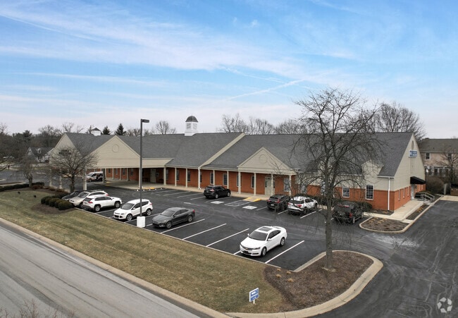
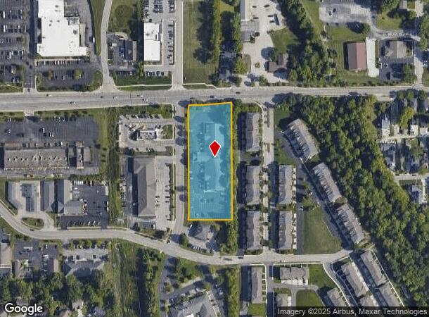
Property Record
33 Brendon Way, Zionsville, IN 46077

NEARBY LISTINGS FOR SALE OR LEASE
Property Detail
33 Brendon Way
06-04-02-000-006.004-006
Zionsville Park Ph Ii A Sub
Medicalbuilding
ZIONSVILLE BUSINESS PARK PHASE II PT OF BLK E 2.05A
X
Boone
18011C0334E
Indiana
2024
2.05 AC
2025
Boone County
810605
Indianapolis
21,076 SF
Indianapolis-Carmel-Anderson, IN
DEMOGRAPHICS near 33 Brendon Way
1 Mile
3 Mile
5 Mile
2024 Total Population
6,681
29,968
90,339
2029 Population
7,558
33,580
98,341
Pop Growth 2024-2029
+ 13.13%
+ 12.05%
+ 8.86%
Average Age
43
40
39
2024 Total Households
2,646
10,796
33,895
HH Growth 2024-2029
+ 13.53%
+ 12.18%
+ 8.05%
Median Household Inc
$98,507
$148,749
$116,515
Avg Household Size
2.40
2.70
2.60
2024 Avg HH Vehicles
2.00
2.00
2.00
Median Home Value
$455,719
$474,083
$418,845
Median Year Built
1987
1999
1998
Nearby Places
Map Layers
Map Styles
 Street
 Aerial
- Restaurants
- Banks
- Shops
- Fitness
- Groceries
PUBLIC TRANSPORTATION
AIRPORT
Indianapolis International
DRIVE
WALK
Distance
Indianapolis International
42 min
23.7 mi
SALE & LEASE HISTORY
LISTING DATE
SALE/LEASE

Sep 24, 2016
For Lease
Jun 23, 2023
For Lease
Jun 10, 2021
For Lease
Nearby Properties
Address
Land Use
TOTAL SIZE
Lot Size
Zoning
Address
Land Use
TOTAL SIZE
Lot Size
Zoning
476,078 SF
8.08 AC
ZO01
Address
Land Use
TOTAL SIZE
Lot Size
Zoning
278,637 SF
43.98 AC
ZO01
Address
Land Use
TOTAL SIZE
Lot Size
Zoning
1,470 SF
19.02 AC
ZO01
Address
Land Use
TOTAL SIZE
Lot Size
Zoning
18,569 SF
9.57 AC
ZO01
Address
Land Use
TOTAL SIZE
Lot Size
Zoning
34,863 SF
14.77 AC
ZO01
Address
Land Use
TOTAL SIZE
Lot Size
Zoning
5,434 SF
11.35 AC
ZO01
Address
Land Use
TOTAL SIZE
Lot Size
Zoning
10,380 SF
24 AC
ZO01
Address
Land Use
TOTAL SIZE
Lot Size
Zoning
68,990 SF
188.21 AC
ZO01
Address
Land Use
TOTAL SIZE
Lot Size
Zoning
301,907 SF
43.90 AC
ZO01
Address
Land Use
TOTAL SIZE
Lot Size
Zoning
111,601 SF
5.74 AC
ZO01
Address
Land Use
TOTAL SIZE
Lot Size
Zoning
115,522 SF
10.38 AC
ZO01
Address
Land Use
TOTAL SIZE
Lot Size
Zoning
3,158 SF
14.16 AC
ZO01
Address
Land Use
TOTAL SIZE
Lot Size
Zoning
149,334 SF
15.89 AC
ZO01
Address
Land Use
TOTAL SIZE
Lot Size
Zoning
75,036 SF
22.39 AC
ZO01
Address
Land Use
TOTAL SIZE
Lot Size
Zoning
9,139 SF
13 AC
ZO01
Address
Land Use
TOTAL SIZE
Lot Size
Zoning
69,864 SF
37.30 AC
ZO01
Address
Land Use
TOTAL SIZE
Lot Size
Zoning
123,575 SF
13.04 AC
Address
Land Use
TOTAL SIZE
Lot Size
Zoning
85,564 SF
2.30 AC
ZO01
Address
Land Use
TOTAL SIZE
Lot Size
Zoning
52,666 SF
9.40 AC
ZO01
Address
Land Use
TOTAL SIZE
Lot Size
Zoning
219,408 SF
20.47 AC
Address
Land Use
TOTAL SIZE
Lot Size
Zoning
66,673 SF
8.74 AC
ZO01
Address
Land Use
TOTAL SIZE
Lot Size
Zoning
75,000 SF
5.40 AC
ZO01
Address
Land Use
TOTAL SIZE
Lot Size
Zoning
174,515 SF
14.21 AC
Address
Land Use
TOTAL SIZE
Lot Size
Zoning
121,033 SF
7.96 AC
ZO01
Address
Land Use
TOTAL SIZE
Lot Size
Zoning
39,218 SF
3.66 AC
ZO01
Address
Land Use
TOTAL SIZE
Lot Size
Zoning
7,144 SF
9.33 AC
ZO01
Address
Land Use
TOTAL SIZE
Lot Size
Zoning
10,626 SF
9 AC
ZO01
Address
Land Use
TOTAL SIZE
Lot Size
Zoning
34,966 SF
20.14 AC
ZO01
Address
Land Use
TOTAL SIZE
Lot Size
Zoning
45,018 SF
6 AC
Address
Land Use
TOTAL SIZE
Lot Size
Zoning
97,779 SF
7.66 AC
The World's #1 Commercial Real Estate Marketplace
Connect with us
© 2025 CoStar Group
The information above has been obtained from sources believed reliable. While we do not doubt its accuracy we have not verified it and make no guarantee, warranty or representation about it. It is your responsibility to independently confirm its accuracy and completeness. Any projections, opinions, assumptions, or estimates used are for example only and do not represent the current or future performance of the property. The value of this transaction to you depends on tax and other factors which should be evaluated by your tax, financial, and legal advisors. You and your advisors should conduct a careful, independent investigation of the property to determine to your satisfaction the suitability of the property for your needs.