Property Record
33 Bryants Cir, Maxton, NC 28364

Property Detail
33 Bryants Cir
1102-01-05001A
AC E/S HWY 71 DRY KILN NO T USED
Storebuilding
ROBESON
B and X Area of moderate flood hazard, usually the area between the limits of the 100-year and 500-year floods.
North Carolina
2025
2.03 AC
2025
North Carolina Southeast Area
962001
Other Market Areas
9,045 SF
Lumberton, NC
NEARBY LISTINGS FOR SALE OR LEASE
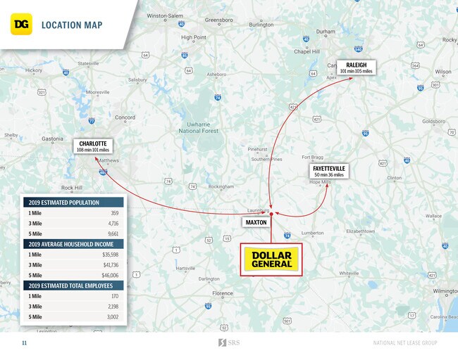
DEMOGRAPHICS near 33 Bryants Cir
1 mile
3 mile
5 mile
2025 Total Population
290
5,803
9,455
2030 Population
303
5,994
9,672
Pop Growth 2025-2030
+ 4.48%
+ 3.29%
+ 2.30%
Average Age
38
39
40
2025 Total Households
107
1,849
2,821
HH Growth 2025-2030
+ 4.67%
+ 4.65%
+ 3.69%
Median Household Inc
$23,333
$29,567
$33,967
Avg Household Size
2.40
2.50
2.60
2025 Avg HH Vehicles
2.00
2.00
2.00
Median Home Value
$72,368
$69,902
$74,884
Median Year Built
1980
1982
1983
Nearby Places
Map Layers
Map Styles
 Street
 Aerial
Layers
 Traffic
 Biking
Places
Listings with unknown addresses are not visible on the map
- Restaurants
- Banks
- Shops
- Fitness
- Groceries
SALE & LEASE HISTORY
LISTING DATE
SALE/LEASE

May 15, 2020
For Sale
Nearby Properties
Address
Land Use
TOTAL SIZE
Lot Size
Zoning
Address
Land Use
TOTAL SIZE
Lot Size
Zoning
208,125 SF
338.14 AC
I2
Address
Land Use
TOTAL SIZE
Lot Size
Zoning
5,000 SF
3,161.45 AC
I2
Address
Land Use
TOTAL SIZE
Lot Size
Zoning
175,000 SF
23.21 AC
I1
Address
Land Use
TOTAL SIZE
Lot Size
Zoning
20,160 SF
32.90 AC
RA
Address
Land Use
TOTAL SIZE
Lot Size
Zoning
17.50 AC
R12
Address
Land Use
TOTAL SIZE
Lot Size
Zoning
30,860 SF
57.89 AC
I2
Address
Land Use
TOTAL SIZE
Lot Size
Zoning
4,632 SF
24.89 AC
I1
Address
Land Use
TOTAL SIZE
Lot Size
Zoning
4,272 SF
8.09 AC
RA
Address
Land Use
TOTAL SIZE
Lot Size
Zoning
153,440 SF
12 AC
I
Address
Land Use
TOTAL SIZE
Lot Size
Zoning
33,318 SF
9.03 AC
R10
Address
Land Use
TOTAL SIZE
Lot Size
Zoning
50,120 SF
31.30 AC
RA
Address
Land Use
TOTAL SIZE
Lot Size
Zoning
6,543 SF
2.12 AC
RA
Address
Land Use
TOTAL SIZE
Lot Size
Zoning
28,090 SF
3.96 AC
HB
Address
Land Use
TOTAL SIZE
Lot Size
Zoning
101,838 SF
26.20 AC
I
Address
Land Use
TOTAL SIZE
Lot Size
Zoning
2,109 SF
1.65 AC
R10
Address
Land Use
TOTAL SIZE
Lot Size
Zoning
111,312 SF
23.70 AC
I
Address
Land Use
TOTAL SIZE
Lot Size
Zoning
24,808 SF
3.87 AC
R12
Address
Land Use
TOTAL SIZE
Lot Size
Zoning
11,424 SF
1.65 AC
NB
Address
Land Use
TOTAL SIZE
Lot Size
Zoning
2,500 SF
10.27 AC
R10
Address
Land Use
TOTAL SIZE
Lot Size
Zoning
458.79 AC
RA
Address
Land Use
TOTAL SIZE
Lot Size
Zoning
10,342 SF
2.05 AC
RSFD
Address
Land Use
TOTAL SIZE
Lot Size
Zoning
3,512 SF
3.50 AC
R12
Address
Land Use
TOTAL SIZE
Lot Size
Zoning
4,557 SF
3.48 AC
R12
Address
Land Use
TOTAL SIZE
Lot Size
Zoning
2,112 SF
21.42 AC
RA
Address
Land Use
TOTAL SIZE
Lot Size
Zoning
10,104 SF
1.77 AC
HB
Address
Land Use
TOTAL SIZE
Lot Size
Zoning
12,360 SF
7.66 AC
HB
Address
Land Use
TOTAL SIZE
Lot Size
Zoning
23,859 SF
1.41 AC
HB
Address
Land Use
TOTAL SIZE
Lot Size
Zoning
8,804 SF
0.87 AC
R12
Address
Land Use
TOTAL SIZE
Lot Size
Zoning
9,936 SF
3.71 AC
Address
Land Use
TOTAL SIZE
Lot Size
Zoning
7,750 SF
1.39 AC
RA
The World's #1 Commercial Real Estate Marketplace
Connect with us
© 2026 CoStar Group
The information above has been obtained from sources believed reliable. While we do not doubt its accuracy we have not verified it and make no guarantee, warranty or representation about it. It is your responsibility to independently confirm its accuracy and completeness. Any projections, opinions, assumptions, or estimates used are for example only and do not represent the current or future performance of the property. The value of this transaction to you depends on tax and other factors which should be evaluated by your tax, financial, and legal advisors. You and your advisors should conduct a careful, independent investigation of the property to determine to your satisfaction the suitability of the property for your needs.