Property Record
33 Demarest Rd, Sparta, NJ 07871

NEARBY LISTINGS FOR SALE OR LEASE
Property Detail
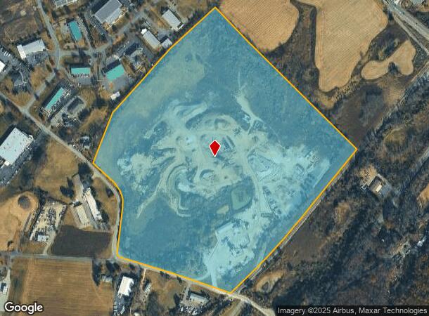
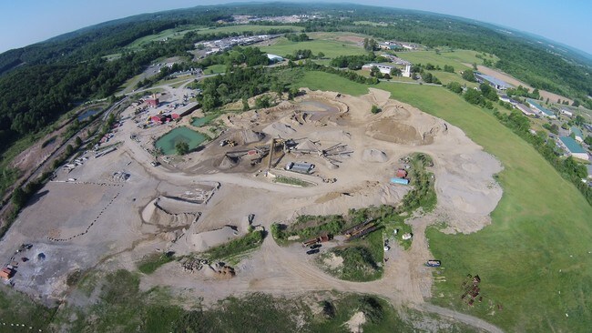
33 Demarest Rd
18-12008-0000-00023-0000-QFARM
Sussex
Farms
New Jersey
X
23
34037C0308E
36 AC
2024
Sussex County
2025
Northern New Jersey
373100
Newark, NJ-PA
DEMOGRAPHICS near 33 Demarest Rd
1 Mile
3 Mile
5 Mile
2024 Total Population
656
9,683
35,319
2029 Population
673
9,782
35,702
Pop Growth 2024-2029
+ 2.59%
+ 1.02%
+ 1.08%
Average Age
40
43
42
2024 Total Households
216
3,369
13,105
HH Growth 2024-2029
+ 2.78%
+ 0.86%
+ 1.09%
Median Household Inc
$160,000
$137,296
$116,214
Avg Household Size
3.00
2.70
2.60
2024 Avg HH Vehicles
2.00
2.00
2.00
Median Home Value
$454,687
$437,189
$370,645
Median Year Built
1989
1983
1972
Nearby Places
Map Layers
Map Styles
 Street
 Aerial
- Restaurants
- Banks
- Shops
- Fitness
- Groceries
SALE & LEASE HISTORY
LISTING DATE
SALE/LEASE

Sep 28, 2017
For Lease
Sep 24, 2016
For Sale
Aug 19, 2019
For Lease
Aug 13, 2019
For Sale
Nearby Properties
Address
Land Use
TOTAL SIZE
Lot Size
Zoning
Address
Land Use
TOTAL SIZE
Lot Size
Zoning
134,375 SF
27.71 AC
OSGU
Address
Land Use
TOTAL SIZE
Lot Size
Zoning
132,501 SF
91.14 AC
OSGU
Address
Land Use
TOTAL SIZE
Lot Size
Zoning
11.86 AC
TCLC
Address
Land Use
TOTAL SIZE
Lot Size
Zoning
156,719 SF
48.98 AC
OSGU
Address
Land Use
TOTAL SIZE
Lot Size
Zoning
28.91 AC
PVC
Address
Land Use
TOTAL SIZE
Lot Size
Zoning
10 AC
RR
Address
Land Use
TOTAL SIZE
Lot Size
Zoning
2.02 AC
PVC
Address
Land Use
TOTAL SIZE
Lot Size
Zoning
50,659 SF
9.90 AC
C-2
Address
Land Use
TOTAL SIZE
Lot Size
Zoning
45,532 SF
10.31 AC
R1
Address
Land Use
TOTAL SIZE
Lot Size
Zoning
2.27 AC
PVC
Address
Land Use
TOTAL SIZE
Lot Size
Zoning
58,605 SF
28.29 AC
OSGU
Address
Land Use
TOTAL SIZE
Lot Size
Zoning
3,280 SF
17.30 AC
MF
Address
Land Use
TOTAL SIZE
Lot Size
Zoning
11,843 SF
9.68 AC
RR
Address
Land Use
TOTAL SIZE
Lot Size
Zoning
34,715 SF
3 AC
TCC
Address
Land Use
TOTAL SIZE
Lot Size
Zoning
47,786 SF
8.60 AC
TCCO
Address
Land Use
TOTAL SIZE
Lot Size
Zoning
35,884 SF
4.73 AC
C-2
Address
Land Use
TOTAL SIZE
Lot Size
Zoning
528 SF
10.85 AC
RR
Address
Land Use
TOTAL SIZE
Lot Size
Zoning
29,156 SF
121.97 AC
L-1
Address
Land Use
TOTAL SIZE
Lot Size
Zoning
5,954 SF
5.07 AC
TCC
Address
Land Use
TOTAL SIZE
Lot Size
Zoning
58.78 AC
PDRM
Address
Land Use
TOTAL SIZE
Lot Size
Zoning
15,400 SF
53.92 AC
PDRM
Address
Land Use
TOTAL SIZE
Lot Size
Zoning
31,504 SF
3.06 AC
ED-1
Address
Land Use
TOTAL SIZE
Lot Size
Zoning
23,184 SF
82.13 AC
OSGU
Address
Land Use
TOTAL SIZE
Lot Size
Zoning
37,638 SF
2.20 AC
TCMS
Address
Land Use
TOTAL SIZE
Lot Size
Zoning
10 AC
RR
Address
Land Use
TOTAL SIZE
Lot Size
Zoning
35,301 SF
3.74 AC
TCC
Address
Land Use
TOTAL SIZE
Lot Size
Zoning
5.59 AC
TCLC
Address
Land Use
TOTAL SIZE
Lot Size
Zoning
42,036 SF
2.94 AC
C-1
Address
Land Use
TOTAL SIZE
Lot Size
Zoning
59,919 SF
21.22 AC
R-2
Address
Land Use
TOTAL SIZE
Lot Size
Zoning
45,445 SF
8.65 AC
ED
The World's #1 Commercial Real Estate Marketplace
Connect with us
© 2025 CoStar Group
The information above has been obtained from sources believed reliable. While we do not doubt its accuracy we have not verified it and make no guarantee, warranty or representation about it. It is your responsibility to independently confirm its accuracy and completeness. Any projections, opinions, assumptions, or estimates used are for example only and do not represent the current or future performance of the property. The value of this transaction to you depends on tax and other factors which should be evaluated by your tax, financial, and legal advisors. You and your advisors should conduct a careful, independent investigation of the property to determine to your satisfaction the suitability of the property for your needs.