Property Record
33 East St, Hebron, CT 06248
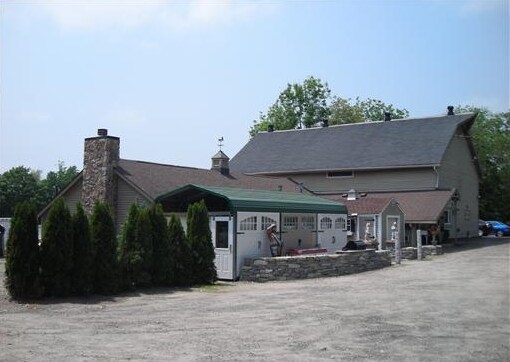

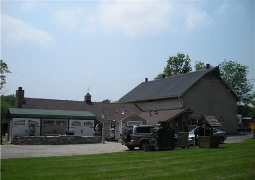
Property Detail
33 East St
Hartford-West Hartford-East Hartford, CT
Capitol
HEBR-000024-000000-000028
Connecticut
Commercialnec
28
R-1
2.28 AC
2025
Tolland County
2025
Hartford
526102
NEARBY LISTINGS FOR SALE OR LEASE
-
-
View all Hebron listings for sale on LoopNet.com
DEMOGRAPHICS near 33 East St
1 mile
3 mile
5 mile
2025 Total Population
516
7,291
20,683
2030 Population
542
7,554
21,224
Pop Growth 2025-2030
+ 5.04%
+ 3.61%
+ 2.62%
Average Age
43
44
44
2025 Total Households
190
2,731
7,833
HH Growth 2025-2030
+ 4.74%
+ 3.55%
+ 2.62%
Median Household Inc
$152,586
$151,413
$137,518
Avg Household Size
2.70
2.70
2.60
2025 Avg HH Vehicles
3.00
2.00
2.00
Median Home Value
$408,928
$397,293
$383,259
Median Year Built
1989
1986
1981
Nearby Places
Map Layers
Map Styles
 Street
 Aerial
Layers
 Traffic
 Biking
Places
Listings with unknown addresses are not visible on the map
- Restaurants
- Banks
- Shops
- Fitness
- Groceries
PUBLIC TRANSPORTATION
AIRPORT
Bradley International
Drive
Walk
Distance
Bradley International
60 min
39.0 mi
Freight Ports
Port of New Haven
Drive
Walk
Distance
Port of New Haven
67 min
48.3 mi
Nearby Properties
Address
Land Use
TOTAL SIZE
Lot Size
Zoning
Address
Land Use
TOTAL SIZE
Lot Size
Zoning
51.66 AC
R-1
Address
Land Use
TOTAL SIZE
Lot Size
Zoning
111,673 SF
6.79 AC
VS
Address
Land Use
TOTAL SIZE
Lot Size
Zoning
82,384 SF
7.50 AC
R-1
Address
Land Use
TOTAL SIZE
Lot Size
Zoning
88,808 SF
25.90 AC
R-1
Address
Land Use
TOTAL SIZE
Lot Size
Zoning
13,030 SF
2.34 AC
MS
Address
Land Use
TOTAL SIZE
Lot Size
Zoning
34,102 SF
5.93 AC
MS
Address
Land Use
TOTAL SIZE
Lot Size
Zoning
15.92 AC
R-1
Address
Land Use
TOTAL SIZE
Lot Size
Zoning
5.07 AC
MS
Address
Land Use
TOTAL SIZE
Lot Size
Zoning
17.50 AC
R-1
Address
Land Use
TOTAL SIZE
Lot Size
Zoning
8,739 SF
0.70 AC
HG
Address
Land Use
TOTAL SIZE
Lot Size
Zoning
9.67 AC
R-1
Address
Land Use
TOTAL SIZE
Lot Size
Zoning
4.53 AC
R-1
Address
Land Use
TOTAL SIZE
Lot Size
Zoning
239 AC
R-1
Address
Land Use
TOTAL SIZE
Lot Size
Zoning
12,412 SF
109.09 AC
R-1
Address
Land Use
TOTAL SIZE
Lot Size
Zoning
13.50 AC
DGE
Address
Land Use
TOTAL SIZE
Lot Size
Zoning
9,153 SF
1.44 AC
MS
Address
Land Use
TOTAL SIZE
Lot Size
Zoning
120 AC
R-1
Address
Land Use
TOTAL SIZE
Lot Size
Zoning
6,374 SF
12.68 AC
R-1
Address
Land Use
TOTAL SIZE
Lot Size
Zoning
6,494 SF
0.79 AC
MS
Address
Land Use
TOTAL SIZE
Lot Size
Zoning
4.03 AC
R-1
Address
Land Use
TOTAL SIZE
Lot Size
Zoning
3.50 AC
R-1
Address
Land Use
TOTAL SIZE
Lot Size
Zoning
141.86 AC
R-1
Address
Land Use
TOTAL SIZE
Lot Size
Zoning
3,224 SF
1.54 AC
MS
Address
Land Use
TOTAL SIZE
Lot Size
Zoning
945 SF
15.67 AC
R-1
Address
Land Use
TOTAL SIZE
Lot Size
Zoning
6,192 SF
1.39 AC
MS
Address
Land Use
TOTAL SIZE
Lot Size
Zoning
6,329 SF
0.80 AC
R-1
Address
Land Use
TOTAL SIZE
Lot Size
Zoning
3.73 AC
R-1
Address
Land Use
TOTAL SIZE
Lot Size
Zoning
7,756 SF
1.08 AC
MS
Address
Land Use
TOTAL SIZE
Lot Size
Zoning
6,192 SF
1.50 AC
HG
Address
Land Use
TOTAL SIZE
Lot Size
Zoning
88.62 AC
VS
The World's #1 Commercial Real Estate Marketplace
Connect with us
© 2026 CoStar Group
The information above has been obtained from sources believed reliable. While we do not doubt its accuracy we have not verified it and make no guarantee, warranty or representation about it. It is your responsibility to independently confirm its accuracy and completeness. Any projections, opinions, assumptions, or estimates used are for example only and do not represent the current or future performance of the property. The value of this transaction to you depends on tax and other factors which should be evaluated by your tax, financial, and legal advisors. You and your advisors should conduct a careful, independent investigation of the property to determine to your satisfaction the suitability of the property for your needs.