Property Record
33 Loop Rd, Arden, NC 28704
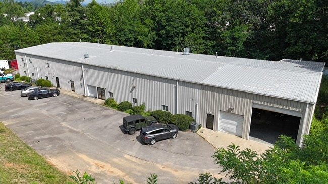

Property Detail
33 Loop Rd
9643-88-5489-00000
SUBDIV: AIRPORT ROAD INDUSTRIAL PARK BLOCK: LOT: 13 SECTION: PLAT: 0000-0000
Warehouse
BUNCOMBE
EMP
North Carolina
B and X Area of moderate flood hazard, usually the area between the limits of the 100-year and 500-year floods.
13
2024
2.04 AC
2025
S Asheville/Royal Pines
002203
Asheville
11,778 SF
Asheville, NC
NEARBY LISTINGS FOR SALE OR LEASE
DEMOGRAPHICS near 33 Loop Rd
1 mile
3 mile
5 mile
2025 Total Population
5,558
31,925
59,448
2030 Population
5,681
32,820
61,273
Pop Growth 2025-2030
+ 2.21%
+ 2.80%
+ 3.07%
Average Age
38
41
43
2025 Total Households
2,273
13,797
25,681
HH Growth 2025-2030
+ 2.11%
+ 2.62%
+ 2.91%
Median Household Inc
$65,227
$78,843
$84,135
Avg Household Size
2.40
2.30
2.30
2025 Avg HH Vehicles
2.00
2.00
2.00
Median Home Value
$267,696
$386,394
$436,257
Median Year Built
1997
1997
1997
Nearby Places
Map Layers
Map Styles
 Street
 Aerial
Transit
 Traffic
 Biking
Places
Listings with unknown addresses are not visible on the map
- Restaurants
- Banks
- Shops
- Fitness
- Groceries
PUBLIC TRANSPORTATION
AIRPORT
Asheville Regional
Drive
Walk
Distance
Asheville Regional
4 min
1.5 mi
SALE & LEASE HISTORY
LISTING DATE
SALE/LEASE

Oct 08, 2024
For Lease
Jul 22, 2024
For Sale
Nearby Properties
Address
Land Use
TOTAL SIZE
Lot Size
Zoning
Address
Land Use
TOTAL SIZE
Lot Size
Zoning
346,375 SF
58.11 AC
INST
Address
Land Use
TOTAL SIZE
Lot Size
Zoning
107,063 SF
567.34 AC
AI
Address
Land Use
TOTAL SIZE
Lot Size
Zoning
110,173 SF
28.13 AC
R-2
Address
Land Use
TOTAL SIZE
Lot Size
Zoning
83,129 SF
44.74 AC
EMP
Address
Land Use
TOTAL SIZE
Lot Size
Zoning
281,505 SF
38.35 AC
10000070~M
Address
Land Use
TOTAL SIZE
Lot Size
Zoning
85,103 SF
11.69 AC
RES EXP
Address
Land Use
TOTAL SIZE
Lot Size
Zoning
66,863 SF
7.48 AC
INST
Address
Land Use
TOTAL SIZE
Lot Size
Zoning
57,836 SF
1.09 AC
UV
Address
Land Use
TOTAL SIZE
Lot Size
Zoning
207,701 SF
458.72 AC
R-3
Address
Land Use
TOTAL SIZE
Lot Size
Zoning
107,408 SF
21.92 AC
R-3
Address
Land Use
TOTAL SIZE
Lot Size
Zoning
183,020 SF
22.84 AC
RM16
Address
Land Use
TOTAL SIZE
Lot Size
Zoning
77,056 SF
19.45 AC
EMP
Address
Land Use
TOTAL SIZE
Lot Size
Zoning
198,705 SF
32.46 AC
HB
Address
Land Use
TOTAL SIZE
Lot Size
Zoning
227,740 SF
36.18 AC
INST
Address
Land Use
TOTAL SIZE
Lot Size
Zoning
218,133 SF
15.39 AC
R-2
Address
Land Use
TOTAL SIZE
Lot Size
Zoning
73,420 SF
10.24 AC
RM16
Address
Land Use
TOTAL SIZE
Lot Size
Zoning
155,715 SF
36.84 AC
RM16
Address
Land Use
TOTAL SIZE
Lot Size
Zoning
80,872 SF
18.84 AC
RM16
Address
Land Use
TOTAL SIZE
Lot Size
Zoning
481,731 SF
86.32 AC
1009658~I
Address
Land Use
TOTAL SIZE
Lot Size
Zoning
93,197 SF
6.32 AC
RES EXP
Address
Land Use
TOTAL SIZE
Lot Size
Zoning
71,574 SF
15.85 AC
RM16
Address
Land Use
TOTAL SIZE
Lot Size
Zoning
332,974 SF
8.38 AC
EMP
Address
Land Use
TOTAL SIZE
Lot Size
Zoning
21.70 AC
10005690~M
Address
Land Use
TOTAL SIZE
Lot Size
Zoning
63,030 SF
5.70 AC
RES EXP
Address
Land Use
TOTAL SIZE
Lot Size
Zoning
3,466 SF
11.32 AC
10000832~M
Address
Land Use
TOTAL SIZE
Lot Size
Zoning
4,839 SF
9.46 AC
10002512~C
Address
Land Use
TOTAL SIZE
Lot Size
Zoning
92,772 SF
12.30 AC
R-2
Address
Land Use
TOTAL SIZE
Lot Size
Zoning
43,882 SF
9.71 AC
1016337~C1
Address
Land Use
TOTAL SIZE
Lot Size
Zoning
24.83 AC
1012291~M-
Address
Land Use
TOTAL SIZE
Lot Size
Zoning
365,659 SF
38.28 AC
9958527~M-
The World's #1 Commercial Real Estate Marketplace
Connect with us
© 2026 CoStar Group
The information above has been obtained from sources believed reliable. While we do not doubt its accuracy we have not verified it and make no guarantee, warranty or representation about it. It is your responsibility to independently confirm its accuracy and completeness. Any projections, opinions, assumptions, or estimates used are for example only and do not represent the current or future performance of the property. The value of this transaction to you depends on tax and other factors which should be evaluated by your tax, financial, and legal advisors. You and your advisors should conduct a careful, independent investigation of the property to determine to your satisfaction the suitability of the property for your needs.