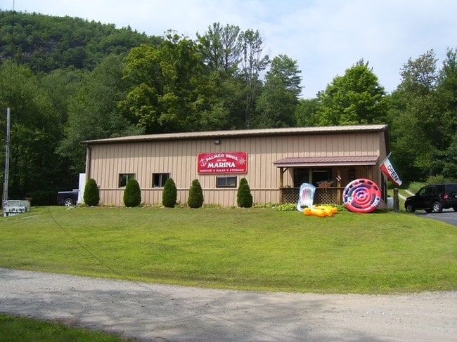
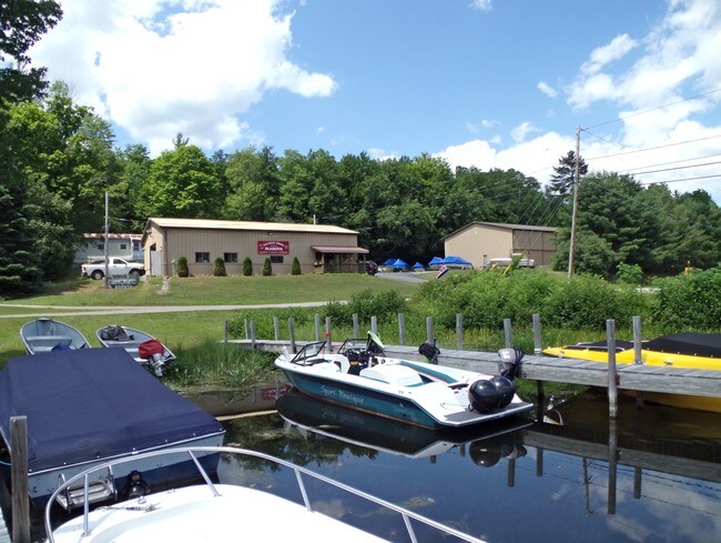
Property Record
33 Palisades Rd, Brant Lake, NY 12815


NEARBY LISTINGS FOR SALE OR LEASE
-
-
View all Brant Lake listings for sale on LoopNet.com
Property Detail
33 Palisades Rd
Glens Falls, NY
48.-1-13
522800 71.20-1-3
Warren
Marinafacility
New York
2025
3.000
2024
3.21 AC
076000
Warren County
2,160 SF
Albany/Schenectady/Troy
DEMOGRAPHICS near 33 Palisades Rd
1 Mile
3 Mile
5 Mile
2024 Total Population
213
1,267
2,788
2029 Population
221
1,296
2,814
Pop Growth 2024-2029
+ 3.76%
+ 2.29%
+ 0.93%
Average Age
51
50
50
2024 Total Households
99
581
1,275
HH Growth 2024-2029
+ 3.03%
+ 2.24%
+ 0.86%
Median Household Inc
$71,249
$70,468
$71,020
Avg Household Size
2.20
2.20
2.10
2024 Avg HH Vehicles
2.00
2.00
2.00
Median Home Value
$277,272
$274,166
$278,744
Median Year Built
1980
1979
1979
Nearby Places
Map Layers
Map Styles
 Street
 Aerial
- Restaurants
- Banks
- Shops
- Fitness
- Groceries
SALE & LEASE HISTORY
LISTING DATE
SALE/LEASE

Sep 24, 2016
For Sale
Oct 23, 2019
For Sale
Nearby Properties
Address
Land Use
TOTAL SIZE
Lot Size
Zoning
Address
Land Use
TOTAL SIZE
Lot Size
Zoning
156,000 SF
105.56 AC
Address
Land Use
TOTAL SIZE
Lot Size
Zoning
3,684 SF
12.43 AC
02
Address
Land Use
TOTAL SIZE
Lot Size
Zoning
4,398 SF
5.91 AC
02
Address
Land Use
TOTAL SIZE
Lot Size
Zoning
4,122 SF
10.72 AC
Address
Land Use
TOTAL SIZE
Lot Size
Zoning
7,868 SF
16.20 AC
02
Address
Land Use
TOTAL SIZE
Lot Size
Zoning
3,931 SF
4.78 AC
Address
Land Use
TOTAL SIZE
Lot Size
Zoning
4,739 SF
1.80 AC
02
Address
Land Use
TOTAL SIZE
Lot Size
Zoning
8,160 SF
7.80 AC
07 - MIXED
Address
Land Use
TOTAL SIZE
Lot Size
Zoning
15,202 SF
27.98 AC
02
Address
Land Use
TOTAL SIZE
Lot Size
Zoning
3,794 SF
2.06 AC
ADPAA
Address
Land Use
TOTAL SIZE
Lot Size
Zoning
9,217 SF
2.11 AC
07 - MIXED
Address
Land Use
TOTAL SIZE
Lot Size
Zoning
8,260 SF
5.90 AC
02
Address
Land Use
TOTAL SIZE
Lot Size
Zoning
100.05 AC
Address
Land Use
TOTAL SIZE
Lot Size
Zoning
5.28 AC
02
Address
Land Use
TOTAL SIZE
Lot Size
Zoning
448 SF
19.36 AC
ADPAA
Address
Land Use
TOTAL SIZE
Lot Size
Zoning
1.89 AC
02
Address
Land Use
TOTAL SIZE
Lot Size
Zoning
5,376 SF
2.61 AC
ADPAA
Address
Land Use
TOTAL SIZE
Lot Size
Zoning
3,630 SF
1.71 AC
02
Address
Land Use
TOTAL SIZE
Lot Size
Zoning
2,070 SF
8 AC
02
Address
Land Use
TOTAL SIZE
Lot Size
Zoning
11,890 SF
6.75 AC
Address
Land Use
TOTAL SIZE
Lot Size
Zoning
1,196 SF
1.26 AC
02
Address
Land Use
TOTAL SIZE
Lot Size
Zoning
1,296 SF
116.34 AC
02
Address
Land Use
TOTAL SIZE
Lot Size
Zoning
2,016 SF
121.86 AC
02
Address
Land Use
TOTAL SIZE
Lot Size
Zoning
3,791 SF
0.92 AC
02
Address
Land Use
TOTAL SIZE
Lot Size
Zoning
2,866 SF
11.47 AC
07 - MIXED
Address
Land Use
TOTAL SIZE
Lot Size
Zoning
6.57 AC
ADPAA
Address
Land Use
TOTAL SIZE
Lot Size
Zoning
1,848 SF
47.40 AC
02
Address
Land Use
TOTAL SIZE
Lot Size
Zoning
70.27 AC
Address
Land Use
TOTAL SIZE
Lot Size
Zoning
912 SF
0.42 AC
02
The World's #1 Commercial Real Estate Marketplace
Connect with us
© 2026 CoStar Group
The information above has been obtained from sources believed reliable. While we do not doubt its accuracy we have not verified it and make no guarantee, warranty or representation about it. It is your responsibility to independently confirm its accuracy and completeness. Any projections, opinions, assumptions, or estimates used are for example only and do not represent the current or future performance of the property. The value of this transaction to you depends on tax and other factors which should be evaluated by your tax, financial, and legal advisors. You and your advisors should conduct a careful, independent investigation of the property to determine to your satisfaction the suitability of the property for your needs.