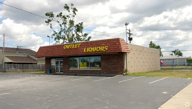
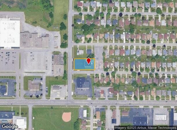
Property Record
33 Patrick Ln, Depew, NY 14043

NEARBY LISTINGS FOR SALE OR LEASE
Property Detail
33 Patrick Ln
143003-092-180-0015-001-110
N.E. COR PATRICK & ENEZ MC 2208-2232 S PT OF 204 DB 10219 PG 802
Privateschool
Erie
X
New York
36029C0236H
1.110
2025
0.50 AC
2024
East
009701
Buffalo/Niagara Falls
3,000 SF
Buffalo-Cheektowaga-Niagara Falls, NY
DEMOGRAPHICS near 33 Patrick Ln
1 Mile
3 Mile
5 Mile
2024 Total Population
10,317
68,461
242,285
2029 Population
10,212
67,725
239,303
Pop Growth 2024-2029
(1.02%)
(1.08%)
(1.23%)
Average Age
45
44
42
2024 Total Households
4,721
31,207
103,627
HH Growth 2024-2029
(1.08%)
(1.15%)
(1.27%)
Median Household Inc
$58,950
$63,411
$62,198
Avg Household Size
2.10
2.10
2.20
2024 Avg HH Vehicles
2.00
2.00
2.00
Median Home Value
$153,167
$155,748
$174,625
Median Year Built
1964
1959
1958
Nearby Places
- Restaurants
- Banks
- Shops
- Fitness
- Groceries
PUBLIC TRANSPORTATION
COMMUTER RAIL
DRIVE
WALK
Distance
4 min
1.5 mi
DRIVE
WALK
Distance
4 min
1.5 mi
AIRPORT
Buffalo Niagara International
DRIVE
WALK
Distance
Buffalo Niagara International
9 min
3.8 mi
Niagara Falls International
DRIVE
WALK
Distance
Niagara Falls International
35 min
19.1 mi
Nearby Properties
Address
Land Use
TOTAL SIZE
Lot Size
Zoning
Address
Land Use
TOTAL SIZE
Lot Size
Zoning
462,256 SF
568.62 AC
05C
Address
Land Use
TOTAL SIZE
Lot Size
Zoning
461,943 SF
21.10 AC
Address
Land Use
TOTAL SIZE
Lot Size
Zoning
262,560 SF
26.40 AC
05C
Address
Land Use
TOTAL SIZE
Lot Size
Zoning
610,311 SF
33.66 AC
05C
Address
Land Use
TOTAL SIZE
Lot Size
Zoning
82,802 SF
12.80 AC
05C
Address
Land Use
TOTAL SIZE
Lot Size
Zoning
420,205 SF
34.42 AC
05
Address
Land Use
TOTAL SIZE
Lot Size
Zoning
172,400 SF
116.50 AC
Address
Land Use
TOTAL SIZE
Lot Size
Zoning
82.29 AC
05C
Address
Land Use
TOTAL SIZE
Lot Size
Zoning
216,724 SF
66.09 AC
05C
Address
Land Use
TOTAL SIZE
Lot Size
Zoning
8,296 SF
16.60 AC
Address
Land Use
TOTAL SIZE
Lot Size
Zoning
172,001 SF
23.49 AC
Address
Land Use
TOTAL SIZE
Lot Size
Zoning
94,165 SF
24.34 AC
05C
Address
Land Use
TOTAL SIZE
Lot Size
Zoning
9,999 SF
27.02 AC
05C
Address
Land Use
TOTAL SIZE
Lot Size
Zoning
722,642 SF
46.80 AC
05C
Address
Land Use
TOTAL SIZE
Lot Size
Zoning
7,200 SF
20.20 AC
03RA
Address
Land Use
TOTAL SIZE
Lot Size
Zoning
140,786 SF
11.88 AC
05C
Address
Land Use
TOTAL SIZE
Lot Size
Zoning
257,248 SF
61.44 AC
05C
Address
Land Use
TOTAL SIZE
Lot Size
Zoning
146,776 SF
9.19 AC
Address
Land Use
TOTAL SIZE
Lot Size
Zoning
40,509 SF
3.30 AC
Address
Land Use
TOTAL SIZE
Lot Size
Zoning
22,000 SF
22.58 AC
05C
Address
Land Use
TOTAL SIZE
Lot Size
Zoning
35,000 SF
30.13 AC
Address
Land Use
TOTAL SIZE
Lot Size
Zoning
6,720 SF
11.10 AC
03RA
Address
Land Use
TOTAL SIZE
Lot Size
Zoning
87,289 SF
11.55 AC
05C
Address
Land Use
TOTAL SIZE
Lot Size
Zoning
175,542 SF
12.70 AC
05C
Address
Land Use
TOTAL SIZE
Lot Size
Zoning
323,590 SF
7.43 AC
05C
Address
Land Use
TOTAL SIZE
Lot Size
Zoning
265,787 SF
21.40 AC
Address
Land Use
TOTAL SIZE
Lot Size
Zoning
150,539 SF
14.65 AC
05C
Address
Land Use
TOTAL SIZE
Lot Size
Zoning
96,501 SF
5.77 AC
Address
Land Use
TOTAL SIZE
Lot Size
Zoning
69,255 SF
8.56 AC
05C
Address
Land Use
TOTAL SIZE
Lot Size
Zoning
1,760 SF
41.19 AC
05C
The World's #1 Commercial Real Estate Marketplace
Connect with us
© 2025 CoStar Group
The information above has been obtained from sources believed reliable. While we do not doubt its accuracy we have not verified it and make no guarantee, warranty or representation about it. It is your responsibility to independently confirm its accuracy and completeness. Any projections, opinions, assumptions, or estimates used are for example only and do not represent the current or future performance of the property. The value of this transaction to you depends on tax and other factors which should be evaluated by your tax, financial, and legal advisors. You and your advisors should conduct a careful, independent investigation of the property to determine to your satisfaction the suitability of the property for your needs.