Property Record
33 Ralph St, Port Jervis, NY 12771
NEARBY LISTINGS FOR SALE OR LEASE
Property Detail
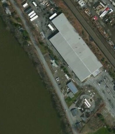
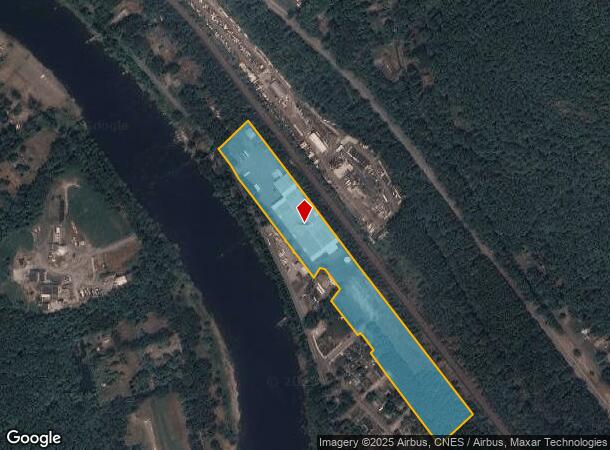
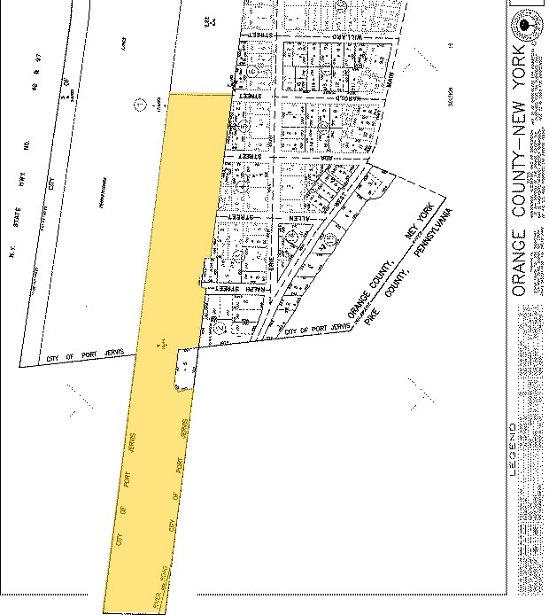
33 Ralph St
331300-010-000-0001-004.000-0000
99 PARTIAL
Warehouse
Orange
X
New York
36071C0214E
4.000
2024
12.40 AC
2024
Orange County
002300
Northern New Jersey
92,444 SF
New York-Jersey City-White Plains, NY-NJ
DEMOGRAPHICS near 33 Ralph St
1 Mile
3 Mile
5 Mile
2024 Total Population
1,691
15,143
20,221
2029 Population
1,696
15,593
20,780
Pop Growth 2024-2029
+ 0.30%
+ 2.97%
+ 2.76%
Average Age
42
42
43
2024 Total Households
677
6,237
8,269
HH Growth 2024-2029
+ 0.30%
+ 3.16%
+ 2.95%
Median Household Inc
$83,333
$54,305
$57,988
Avg Household Size
2.50
2.40
2.40
2024 Avg HH Vehicles
2.00
2.00
2.00
Median Home Value
$184,438
$190,716
$203,503
Median Year Built
1948
1957
1966
Nearby Places
Map Layers
Map Styles
 Street
 Aerial
- Restaurants
- Banks
- Shops
- Fitness
- Groceries
PUBLIC TRANSPORTATION
COMMUTER RAIL
Port Jervis (Bergen County/Port Jervis Line - NJ Transit Commuter Rail (NJ Transit), Main/Port Jervis Line - NJ Transit Commuter Rail (NJ Transit))
DRIVE
WALK
Distance
Port Jervis (Bergen County/Port Jervis Line - NJ Transit Commuter Rail (NJ Transit), Main/Port Jervis Line - NJ Transit Commuter Rail (NJ Transit))
7 min
2.1 mi
Freight Ports
Port Newark Container Terminal
DRIVE
WALK
Distance
Port Newark Container Terminal
103 min
71.2 mi
Nearby Properties
Address
Land Use
TOTAL SIZE
Lot Size
Zoning
Address
Land Use
TOTAL SIZE
Lot Size
Zoning
4.40 AC
NMU
Address
Land Use
TOTAL SIZE
Lot Size
Zoning
1,664 SF
1.10 AC
R2
Address
Land Use
TOTAL SIZE
Lot Size
Zoning
4.30 AC
07
Address
Land Use
TOTAL SIZE
Lot Size
Zoning
49.20 AC
Address
Land Use
TOTAL SIZE
Lot Size
Zoning
14,077 SF
2.20 AC
MCD
Address
Land Use
TOTAL SIZE
Lot Size
Zoning
94,928 SF
77.10 AC
Address
Land Use
TOTAL SIZE
Lot Size
Zoning
213,940 SF
31.45 AC
Address
Land Use
TOTAL SIZE
Lot Size
Zoning
4.10 AC
R2
Address
Land Use
TOTAL SIZE
Lot Size
Zoning
3,030 SF
10.50 AC
Address
Land Use
TOTAL SIZE
Lot Size
Zoning
3,030 SF
13.84 AC
Address
Land Use
TOTAL SIZE
Lot Size
Zoning
53,254 SF
4.10 AC
SCAH
Address
Land Use
TOTAL SIZE
Lot Size
Zoning
20,914 SF
1.10 AC
NMU
Address
Land Use
TOTAL SIZE
Lot Size
Zoning
141,186 SF
15.22 AC
Address
Land Use
TOTAL SIZE
Lot Size
Zoning
97,962 SF
8.90 AC
CBD
Address
Land Use
TOTAL SIZE
Lot Size
Zoning
56,864 SF
2.54 AC
Address
Land Use
TOTAL SIZE
Lot Size
Zoning
102,497 SF
3.90 AC
LI
Address
Land Use
TOTAL SIZE
Lot Size
Zoning
3.50 AC
C2
Address
Land Use
TOTAL SIZE
Lot Size
Zoning
72,575 SF
7.26 AC
Address
Land Use
TOTAL SIZE
Lot Size
Zoning
25,042 SF
2.10 AC
07
Address
Land Use
TOTAL SIZE
Lot Size
Zoning
3,007 SF
59.03 AC
R-1
Address
Land Use
TOTAL SIZE
Lot Size
Zoning
28,725 SF
1.40 AC
NMU
Address
Land Use
TOTAL SIZE
Lot Size
Zoning
21.10 AC
R1
Address
Land Use
TOTAL SIZE
Lot Size
Zoning
87,263 SF
10.78 AC
Address
Land Use
TOTAL SIZE
Lot Size
Zoning
73,625 SF
3.60 AC
LI
Address
Land Use
TOTAL SIZE
Lot Size
Zoning
77,935 SF
50.77 AC
Address
Land Use
TOTAL SIZE
Lot Size
Zoning
40,500 SF
2.60 AC
R2
Address
Land Use
TOTAL SIZE
Lot Size
Zoning
18,584 SF
1.51 AC
CBD
Address
Land Use
TOTAL SIZE
Lot Size
Zoning
9,068 SF
1.80 AC
R2
Address
Land Use
TOTAL SIZE
Lot Size
Zoning
62,240 SF
4.60 AC
LI
The World's #1 Commercial Real Estate Marketplace
Connect with us
© 2026 CoStar Group
The information above has been obtained from sources believed reliable. While we do not doubt its accuracy we have not verified it and make no guarantee, warranty or representation about it. It is your responsibility to independently confirm its accuracy and completeness. Any projections, opinions, assumptions, or estimates used are for example only and do not represent the current or future performance of the property. The value of this transaction to you depends on tax and other factors which should be evaluated by your tax, financial, and legal advisors. You and your advisors should conduct a careful, independent investigation of the property to determine to your satisfaction the suitability of the property for your needs.