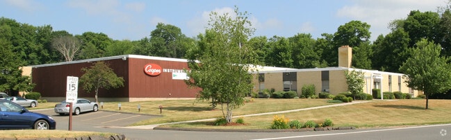
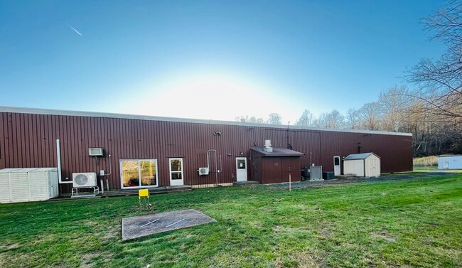
Property Record
33 Reeds Gap Rd, Middlefield, CT 06455

Property Detail
33 Reeds Gap Rd
MFLD-000017-000000-000009
Lower Ct River Vly
Industrialgeneral
Connecticut
IPD2
9
B and X Area of moderate flood hazard, usually the area between the limits of the 100-year and 500-year floods.
8 AC
2025
NW Middlesex/Mid'town
2025
Hartford
580100
Hartford-West Hartford-East Hartford, CT
39,520 SF
NEARBY LISTINGS FOR SALE OR LEASE
DEMOGRAPHICS near 33 Reeds Gap Rd
1 mile
3 mile
5 mile
2025 Total Population
546
11,842
68,785
2030 Population
545
11,914
69,371
Pop Growth 2025-2030
(0.18%)
+ 0.61%
+ 0.85%
Average Age
45
45
42
2025 Total Households
223
4,816
27,264
HH Growth 2025-2030
0.00%
+ 0.64%
+ 0.81%
Median Household Inc
$124,374
$106,840
$87,318
Avg Household Size
2.40
2.40
2.40
2025 Avg HH Vehicles
2.00
2.00
2.00
Median Home Value
$419,000
$341,861
$307,891
Median Year Built
1972
1973
1967
Nearby Places
Map Layers
Map Styles
 Street
 Aerial
Layers
 Traffic
 Biking
Places
Listings with unknown addresses are not visible on the map
- Restaurants
- Banks
- Shops
- Fitness
- Groceries
PUBLIC TRANSPORTATION
COMMUTER RAIL
Drive
Walk
Distance
14 min
7.7 mi
Drive
Walk
Distance
15 min
8.0 mi
AIRPORT
Tweed/New Haven
Drive
Walk
Distance
Tweed/New Haven
37 min
23.6 mi
Bradley International
Drive
Walk
Distance
Bradley International
63 min
38.9 mi
SALE & LEASE HISTORY
LISTING DATE
SALE/LEASE

Dec 16, 2022
For Sale
Nearby Properties
Address
Land Use
TOTAL SIZE
Lot Size
Zoning
Address
Land Use
TOTAL SIZE
Lot Size
Zoning
10.38 AC
M-1
Address
Land Use
TOTAL SIZE
Lot Size
Zoning
329,296 SF
35.55 AC
IX
Address
Land Use
TOTAL SIZE
Lot Size
Zoning
339,844 SF
52.43 AC
M-4
Address
Land Use
TOTAL SIZE
Lot Size
Zoning
187,914 SF
16.13 AC
IX
Address
Land Use
TOTAL SIZE
Lot Size
Zoning
203,692 SF
21.22 AC
IX
Address
Land Use
TOTAL SIZE
Lot Size
Zoning
166,724 SF
21.79 AC
M-2
Address
Land Use
TOTAL SIZE
Lot Size
Zoning
81,496 SF
5.96 AC
WI
Address
Land Use
TOTAL SIZE
Lot Size
Zoning
94,044 SF
5.48 AC
WI
Address
Land Use
TOTAL SIZE
Lot Size
Zoning
20,330 SF
174.02 AC
WI
Address
Land Use
TOTAL SIZE
Lot Size
Zoning
115,951 SF
14.77 AC
M-1
Address
Land Use
TOTAL SIZE
Lot Size
Zoning
124,940 SF
49.46 AC
FARM -
Address
Land Use
TOTAL SIZE
Lot Size
Zoning
171,057 SF
25.06 AC
M-4
Address
Land Use
TOTAL SIZE
Lot Size
Zoning
98,894 SF
44.82 AC
WI
Address
Land Use
TOTAL SIZE
Lot Size
Zoning
18.61 AC
C-2
Address
Land Use
TOTAL SIZE
Lot Size
Zoning
326,730 SF
25.19 AC
M-1
Address
Land Use
TOTAL SIZE
Lot Size
Zoning
81,358 SF
9.64 AC
WI
Address
Land Use
TOTAL SIZE
Lot Size
Zoning
20.60 AC
I-4
Address
Land Use
TOTAL SIZE
Lot Size
Zoning
187,744 SF
31.68 AC
M-1
Address
Land Use
TOTAL SIZE
Lot Size
Zoning
86,171 SF
6.60 AC
WI
Address
Land Use
TOTAL SIZE
Lot Size
Zoning
70,112 SF
9.20 AC
WI
Address
Land Use
TOTAL SIZE
Lot Size
Zoning
69,179 SF
15.90 AC
WI
Address
Land Use
TOTAL SIZE
Lot Size
Zoning
49,299 SF
19.98 AC
IPD1
Address
Land Use
TOTAL SIZE
Lot Size
Zoning
82,685 SF
10.32 AC
IX
Address
Land Use
TOTAL SIZE
Lot Size
Zoning
168,702 SF
48.80 AC
RDD
Address
Land Use
TOTAL SIZE
Lot Size
Zoning
20.60 AC
RDD
Address
Land Use
TOTAL SIZE
Lot Size
Zoning
52,668 SF
14.02 AC
WI
Address
Land Use
TOTAL SIZE
Lot Size
Zoning
55,734 SF
44.63 AC
R-R
Address
Land Use
TOTAL SIZE
Lot Size
Zoning
62,464 SF
9.28 AC
IX
Address
Land Use
TOTAL SIZE
Lot Size
Zoning
639 SF
11.77 AC
R-1
Address
Land Use
TOTAL SIZE
Lot Size
Zoning
40,938 SF
14.53 AC
FARM -
The World's #1 Commercial Real Estate Marketplace
Connect with us
© 2026 CoStar Group
The information above has been obtained from sources believed reliable. While we do not doubt its accuracy we have not verified it and make no guarantee, warranty or representation about it. It is your responsibility to independently confirm its accuracy and completeness. Any projections, opinions, assumptions, or estimates used are for example only and do not represent the current or future performance of the property. The value of this transaction to you depends on tax and other factors which should be evaluated by your tax, financial, and legal advisors. You and your advisors should conduct a careful, independent investigation of the property to determine to your satisfaction the suitability of the property for your needs.